Luperón elevation
Luperón (Puerto Plata), Dominican Republic elevation is 11 meters and Luperón elevation in feet is 36 ft above sea level [src 1]. Luperón is a populated place (feature code) with elevation that is 152 meters (499 ft) smaller than average city elevation in Dominican Republic.
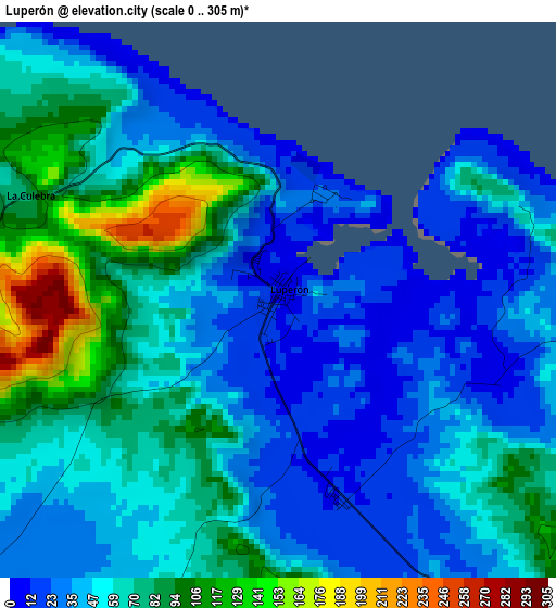
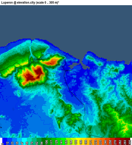
Below is the Elevation map of Luperón, which displays elevation range with different colors. Scale of the first map is from 0 to 305 m (0 to 1001 ft) with average elevation of 57.6 meters (=189 ft) [note 1]
These maps also provides idea of topography and contour of this city, they are displayed at different zoom levels. More info about maps, scale and edge coordinates you can find below images.
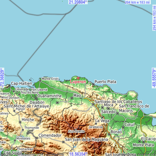
| \ | Map #1 | Map #2 | Topo.Map |
| Scale [m] | 0..305 m | 0..305 m | × |
| Scale [ft] | 0..1001 ft | 0..1001 ft | × |
| Average | 57.6 m = 189 ft | 62.1 m = 204 ft | × |
| Width | 9.19 km = 5.7 mi | 18.38 km = 11.4 mi | 294 km = 182.7 mi |
| Height | 9.19 km = 5.7 mi | 18.38 km = 11.4 mi | 294.1 km = 182.7 mi |
| ↑Max Latitude | 19.932628° | 19.973935° | 21.20804° |
| Latitude at center | 19.89131° | 19.89131° | 19.89131° |
| ↓Min Latitude | 19.849981° | 19.808641° | 18.56354° |
| ← Min Longitude | -71.005985° | -71.049931° | -72.36829° |
| Longitude center | -70.96204° | -70.96204° | -70.96204° |
| →Max Longitude | -70.918095° | -70.874149° | -69.55579° |
Nearby cities:
Cities around Luperón sort by population:
• Puerto Plata elevation 34 m
30.6 km,  110°
110°
• Río Grande 397 m
32.3 km,  140°
140°
• Imbert 121 m
20.7 km, 137°
• Laguna Salada 77 m
29.7 km,  205°
205°
• Altamira 317 m
26.8 km,  152°
152°
• Villa Isabela 40 m
13.3 km,  230°
230°
• Maizal 82 m
29.1 km,  193°
193°
• Los Hidalgos 195 m
19.1 km,  203°
203°
• Guananico 155 m
18.7 km,  167°
167°
• Jicomé 416 m
26.9 km,  177°
177°
• Estero Hondo 13 m
23.3 km,  252°
252°
• La Caya 173 m
27 km,  217°
217°
Multilingual:
 En español:
Luperón elevación 11 m.
 En France:
Luperón élévation 11 m.


Sources and notes:
- [note 1] Map square and city borders are not equal. Map elevation data is calculated only from area inside that square.
- [src 1] Elevation data from geonames database provided with same terms of usage.
- [src 2] The elevation map of Luperón is generated using elevation data from NASA's 3 arcsec (90m) resolution SRTM data.
- [src 3] Base (background) map © OpenStreetMap contributors tiles are generated by Geofabrik and OpenTopoMap.
Copyright & License:
This Luperón Elevation Map is licensed under CC BY-SA. You may reuse any part from this page, if you give a proper credit by linking to this URL:
 More info on terms of use page.