Puerto Plata elevation
Puerto Plata, Dominican Republic elevation is 34 meters and Puerto Plata elevation in feet is 112 ft above sea level [src 1]. Puerto Plata is a seat of a first-order administrative division (feature code) with elevation that is 129 meters (423 ft) smaller than average city elevation in Dominican Republic.
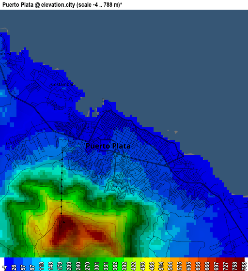
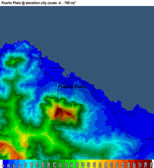
Below is the Elevation map of Puerto Plata, which displays elevation range with different colors. Scale of the first map is from -4 to 788 m (-13 to 2585 ft) with average elevation of 145.3 meters (=477 ft) [note 1]
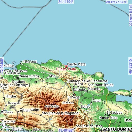
These maps also provides idea of topography and contour of this city, they are displayed at different zoom levels. More info about maps, scale and edge coordinates you can find below images.
| \ | Map #1 | Map #2 | Topo.Map |
| Scale [m] | -4..788 m | -4..788 m | × |
| Scale [ft] | -13..2585 ft | -13..2585 ft | × |
| Average | 145.3 m = 477 ft | 168.2 m = 552 ft | × |
| Width | 9.2 km = 5.7 mi | 18.39 km = 11.4 mi | 294.2 km = 182.8 mi |
| Height | 9.2 km = 5.7 mi | 18.39 km = 11.4 mi | 294.2 km = 182.8 mi |
| ↑Max Latitude | 19.834784° | 19.876117° | 21.11101° |
| Latitude at center | 19.79344° | 19.79344° | 19.79344° |
| ↓Min Latitude | 19.752086° | 19.710721° | 18.46488° |
| ← Min Longitude | -70.732345° | -70.776291° | -72.09465° |
| Longitude center | -70.6884° | -70.6884° | -70.6884° |
| →Max Longitude | -70.644455° | -70.600509° | -69.28215° |
Nearby cities:
Cities around Puerto Plata sort by population:
• Río Grande elevation 397 m
16.3 km,  210°
210°
• Monte Llano 12 m
11.4 km,  125°
125°
• Villa González 164 m
30 km,  200°
200°
• Imbert 121 m
15.4 km,  253°
253°
• Sosúa 27 m
18.2 km,  104°
104°
• Altamira 317 m
20.8 km,  231°
231°
• Luperón 11 m
30.6 km,  290°
290°
• Cabarete 12 m
29.7 km, 99°
• Palmar Arriba 177 m
28.7 km,  190°
190°
• Guananico 155 m
25.6 km, 253°
• Jamao al Norte 51 m
30.8 km,  124°
124°
• Pedro García 454 m
22.7 km,  170°
170°
Multilingual:
 En español:
San Felipe de Puerto Plata elevación 34 m.
 En France:
Puerto Plata élévation 34 m.
 Auf Deutsch:
Puerto Plata höhe über dem Meeresspiegel ist 34 m.
 На русском:
Сан-Фелипе-де-Пуэрто-Плата высота над уровнем моря 34 м
Sources and notes:
- [note 1] Map square and city borders are not equal. Map elevation data is calculated only from area inside that square.
- [src 1] Elevation data from geonames database provided with same terms of usage.
- [src 2] The elevation map of Puerto Plata is generated using elevation data from NASA's 3 arcsec (90m) resolution SRTM data.
- [src 3] Base (background) map © OpenStreetMap contributors tiles are generated by Geofabrik and OpenTopoMap.
Copyright & License:
This Puerto Plata Elevation Map is licensed under CC BY-SA. You may reuse any part from this page, if you give a proper credit by linking to this URL:
 More info on terms of use page.