Laguna Salada elevation
Laguna Salada (Valverde), Dominican Republic elevation is 77 meters and Laguna Salada elevation in feet is 253 ft above sea level [src 1]. Laguna Salada is a seat of a second-order administrative division (feature code) with elevation that is 86 meters (282 ft) smaller than average city elevation in Dominican Republic.
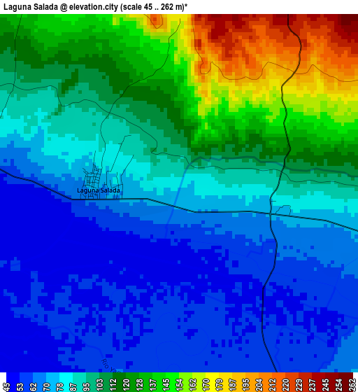
Below is the Elevation map of Laguna Salada, which displays elevation range with different colors. Scale of the first map is from 45 to 262 m (148 to 860 ft) with average elevation of 95 meters (=312 ft) [note 1]
These maps also provides idea of topography and contour of this city, they are displayed at different zoom levels. More info about maps, scale and edge coordinates you can find below images.
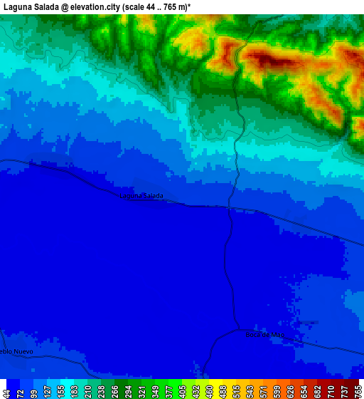
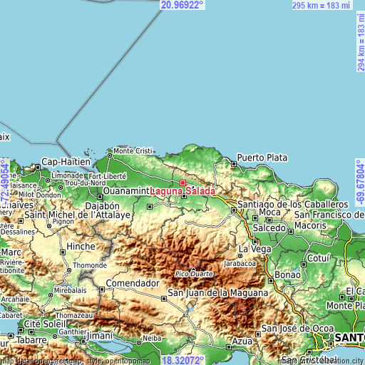
| \ | Map #1 | Map #2 | Topo.Map |
| Scale [m] | 45..262 m | 44..765 m | × |
| Scale [ft] | 148..860 ft | 144..2510 ft | × |
| Average | 95 m = 312 ft | 147.8 m = 485 ft | × |
| Width | 9.2 km = 5.7 mi | 18.41 km = 11.4 mi | 294.5 km = 183 mi |
| Height | 9.2 km = 5.7 mi | 18.41 km = 11.4 mi | 294.5 km = 183 mi |
| ↑Max Latitude | 19.691811° | 19.733181° | 20.96922° |
| Latitude at center | 19.65043° | 19.65043° | 19.65043° |
| ↓Min Latitude | 19.609039° | 19.567637° | 18.32072° |
| ← Min Longitude | -71.128235° | -71.172181° | -72.49054° |
| Longitude center | -71.08429° | -71.08429° | -71.08429° |
| →Max Longitude | -71.040345° | -70.996399° | -69.67804° |
Nearby cities:
Cities around Laguna Salada sort by population:
• Mao elevation 85 m
11 km,  176°
176°
• Esperanza 113 m
12.7 km,  125°
125°
• Jaibón 51 m
8 km,  237°
237°
• Villa Isabela 40 m
18.5 km,  7°
7°
• Hatillo Palma 74 m
11.6 km,  276°
276°
• Maizal 82 m
6.2 km,  104°
104°
• Los Hidalgos 195 m
10.7 km,  30°
30°
• Guananico 155 m
18.9 km,  63°
63°
• Amina 80 m
14.7 km,  140°
140°
• Cana Chapetón 63 m
18.8 km,  255°
255°
• Jicomé 416 m
14.1 km,  90°
90°
• La Caya 173 m
6.7 km,  325°
325°
Multilingual:
 En español:
Laguna Salada elevación 77 m.
 En France:
Laguna Salada élévation 77 m.
 Auf Deutsch:
Laguna Salada höhe über dem Meeresspiegel ist 77 m.

Sources and notes:
- [note 1] Map square and city borders are not equal. Map elevation data is calculated only from area inside that square.
- [src 1] Elevation data from geonames database provided with same terms of usage.
- [src 2] The elevation map of Laguna Salada is generated using elevation data from NASA's 3 arcsec (90m) resolution SRTM data.
- [src 3] Base (background) map © OpenStreetMap contributors tiles are generated by Geofabrik and OpenTopoMap.
Copyright & License:
This Laguna Salada Elevation Map is licensed under CC BY-SA. You may reuse any part from this page, if you give a proper credit by linking to this URL:
 More info on terms of use page.