Monción elevation
Monción (Santiago Rodríguez), Dominican Republic elevation is 372 meters and Monción elevation in feet is 1220 ft above sea level [src 1]. Monción is a populated place (feature code) with elevation that is 209 meters (686 ft) bigger than average city elevation in Dominican Republic.
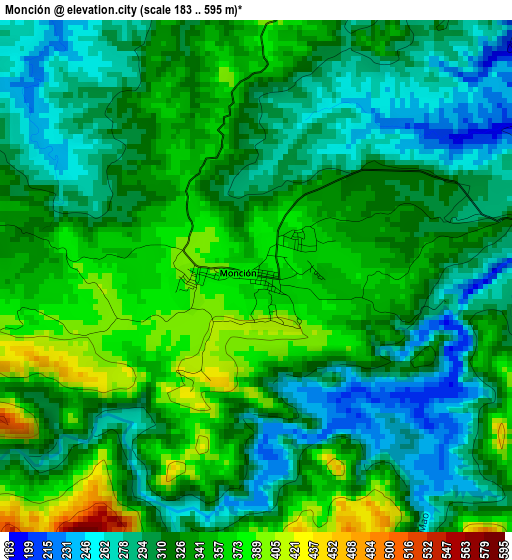
Below is the Elevation map of Monción, which displays elevation range with different colors. Scale of the first map is from 183 to 595 m (600 to 1952 ft) with average elevation of 324.4 meters (=1064 ft) [note 1]
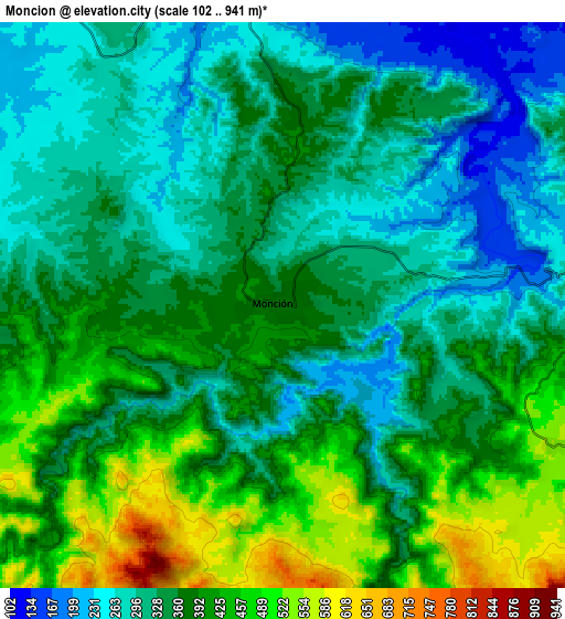
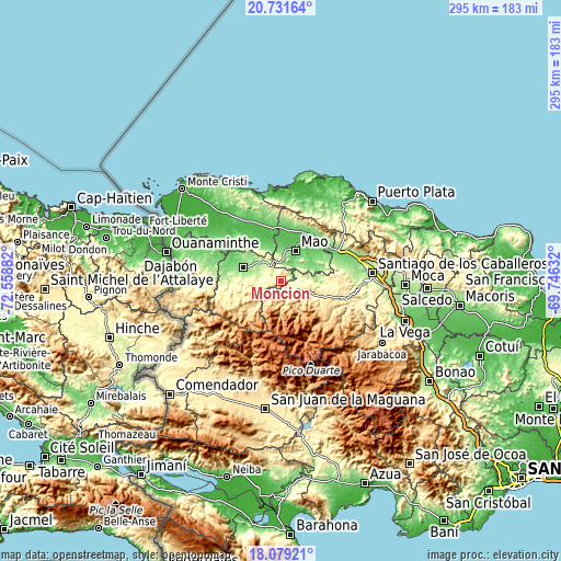
These maps also provides idea of topography and contour of this city, they are displayed at different zoom levels. More info about maps, scale and edge coordinates you can find below images.
| \ | Map #1 | Map #2 | Topo.Map |
| Scale [m] | 183..595 m | 102..941 m | × |
| Scale [ft] | 600..1952 ft | 335..3087 ft | × |
| Average | 324.4 m = 1064 ft | 361.8 m = 1187 ft | × |
| Width | 9.22 km = 5.7 mi | 18.43 km = 11.5 mi | 294.9 km = 183.2 mi |
| Height | 9.22 km = 5.7 mi | 18.43 km = 11.5 mi | 294.9 km = 183.2 mi |
| ↑Max Latitude | 19.452272° | 19.493704° | 20.73164° |
| Latitude at center | 19.41083° | 19.41083° | 19.41083° |
| ↓Min Latitude | 19.369377° | 19.327914° | 18.07921° |
| ← Min Longitude | -71.196515° | -71.240461° | -72.55882° |
| Longitude center | -71.15257° | -71.15257° | -71.15257° |
| →Max Longitude | -71.108625° | -71.064679° | -69.74632° |
Nearby cities:
Cities around Monción sort by population:
• Mao elevation 85 m
17.5 km,  26°
26°
• Esperanza 113 m
26.1 km,  42°
42°
• Sabaneta 127 m
21.1 km,  290°
290°
• San José de Las Matas 524 m
23.9 km,  109°
109°
• Laguna Salada 77 m
27.6 km,  15°
15°
• Jaibón 51 m
22.3 km,  1°
1°
• Hatillo Palma 74 m
28.3 km,  351°
351°
• Maizal 82 m
28.3 km, 27°
• Amina 80 m
22.4 km,  47°
47°
• Cana Chapetón 63 m
24.4 km,  333°
333°
• Guatapanal 150 m
26.9 km,  66°
66°
• La Caya 173 m
32.3 km,  5°
5°
Multilingual:
 En español:
Monción elevación 372 m.
 En France:
Monción élévation 372 m.


Sources and notes:
- [note 1] Map square and city borders are not equal. Map elevation data is calculated only from area inside that square.
- [src 1] Elevation data from geonames database provided with same terms of usage.
- [src 2] The elevation map of Monción is generated using elevation data from NASA's 3 arcsec (90m) resolution SRTM data.
- [src 3] Base (background) map © OpenStreetMap contributors tiles are generated by Geofabrik and OpenTopoMap.
Copyright & License:
This Monción Elevation Map is licensed under CC BY-SA. You may reuse any part from this page, if you give a proper credit by linking to this URL:
 More info on terms of use page.