Bjerringbro elevation
Bjerringbro (Central Jutland, Viborg Kommune), Denmark elevation is 14 meters and Bjerringbro elevation in feet is 46 ft above sea level [src 1]. Bjerringbro is a populated place (feature code) with elevation that is 13 meters (43 ft) smaller than average city elevation in Denmark.
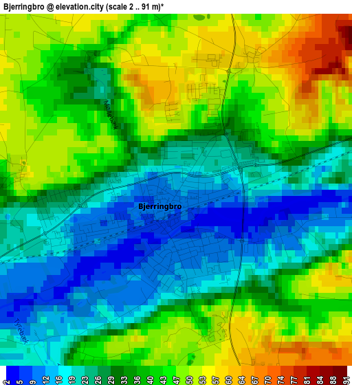
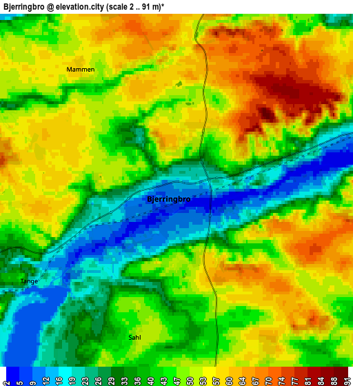
Below is the Elevation map of Bjerringbro, which displays elevation range with different colors. Scale of the first map is from 2 to 91 m (7 to 299 ft) with average elevation of 35.1 meters (=115 ft) [note 1]
These maps also provides idea of topography and contour of this city, they are displayed at different zoom levels. More info about maps, scale and edge coordinates you can find below images.
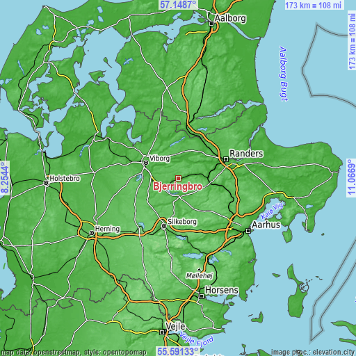
| \ | Map #1 | Map #2 | Topo.Map |
| Scale [m] | 2..91 m | 2..91 m | × |
| Scale [ft] | 7..299 ft | 7..299 ft | × |
| Average | 35.1 m = 115 ft | 45.1 m = 148 ft | × |
| Width | 5.41 km = 3.4 mi | 10.82 km = 6.7 mi | 173.2 km = 107.6 mi |
| Height | 5.41 km = 3.4 mi | 10.82 km = 6.7 mi | 173.1 km = 107.6 mi |
| ↑Max Latitude | 56.402295° | 56.426605° | 57.1487° |
| Latitude at center | 56.37797° | 56.37797° | 56.37797° |
| ↓Min Latitude | 56.353629° | 56.329273° | 55.59133° |
| ← Min Longitude | 9.616705° | 9.572759° | 8.2544° |
| Longitude center | 9.66065° | 9.66065° | 9.66065° |
| →Max Longitude | 9.704595° | 9.748541° | 11.0669° |
Nearby cities:
Cities around Bjerringbro sort by population:
• Randers elevation 12 m
24.9 km,  68°
68°
• Silkeborg 19 m
24.2 km,  197°
197°
• Viborg 50 m
18 km,  297°
297°
• Hinnerup 30 m
27.8 km,  116°
116°
• Hadsten 30 m
24.6 km,  103°
103°
• Hammel 66 m
18.3 km,  136°
136°
• Galten 45 m
29 km,  146°
146°
• Kjellerup 63 m
17.3 km,  233°
233°
• Svejbæk 32 m
27.3 km,  183°
183°
• Virklund 54 m
28.1 km,  193°
193°
• Langå 16 m
14.5 km,  84°
84°
• Ulstrup 12 m
8.3 km, 80°
Multilingual:
 En español:
Bjerringbro elevación 14 m.
 En France:
Bjerringbro élévation 14 m.
 Auf Deutsch:
Bjerringbro höhe über dem Meeresspiegel ist 14 m.

Sources and notes:
- [note 1] Map square and city borders are not equal. Map elevation data is calculated only from area inside that square.
- [src 1] Elevation data from geonames database provided with same terms of usage.
- [src 2] The elevation map of Bjerringbro is generated using elevation data from NASA's 3 arcsec (90m) resolution SRTM data.
- [src 3] Base (background) map © OpenStreetMap contributors tiles are generated by Geofabrik and OpenTopoMap.
Copyright & License:
This Bjerringbro Elevation Map is licensed under CC BY-SA. You may reuse any part from this page, if you give a proper credit by linking to this URL:
 More info on terms of use page.