Hinnerup elevation
Hinnerup (Central Jutland, Favrskov Kommune), Denmark elevation is 30 meters and Hinnerup elevation in feet is 98 ft above sea level [src 1]. Hinnerup is a seat of a second-order administrative division (feature code) with elevation that is 3 meters (10 ft) bigger than average city elevation in Denmark.
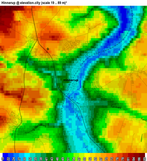
Below is the Elevation map of Hinnerup, which displays elevation range with different colors. Scale of the first map is from 19 to 89 m (62 to 292 ft) with average elevation of 54.3 meters (=178 ft) [note 1]
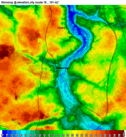
These maps also provides idea of topography and contour of this city, they are displayed at different zoom levels. More info about maps, scale and edge coordinates you can find below images.
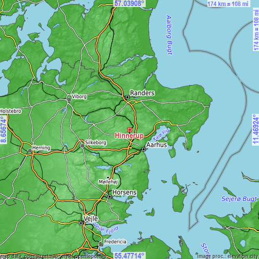
| \ | Map #1 | Map #2 | Topo.Map |
| Scale [m] | 19..89 m | 16..101 m | × |
| Scale [ft] | 62..292 ft | 52..331 ft | × |
| Average | 54.3 m = 178 ft | 61 m = 200 ft | × |
| Width | 5.43 km = 3.4 mi | 10.85 km = 6.7 mi | 173.7 km = 107.9 mi |
| Height | 5.43 km = 3.4 mi | 10.85 km = 6.7 mi | 173.7 km = 107.9 mi |
| ↑Max Latitude | 56.290477° | 56.314858° | 57.03908° |
| Latitude at center | 56.26608° | 56.26608° | 56.26608° |
| ↓Min Latitude | 56.241668° | 56.21724° | 55.47714° |
| ← Min Longitude | 10.019045° | 9.975099° | 8.65674° |
| Longitude center | 10.06299° | 10.06299° | 10.06299° |
| →Max Longitude | 10.106935° | 10.150881° | 11.46924° |
Nearby cities:
Cities around Hinnerup sort by population:
• Århus elevation 10 m
15.2 km,  143°
143°
• Lystrup 48 m
11.3 km,  106°
106°
• Hadsten 30 m
7 km,  353°
353°
• Hammel 66 m
12.4 km,  265°
265°
• Løgten 69 m
15.4 km,  86°
86°
• Galten 45 m
14.9 km,  217°
217°
• Framlev 39 m
12.6 km,  194°
194°
• Hjortshøj 50 m
12.7 km,  99°
99°
• Skovby 37 m
14.2 km,  210°
210°
• Trige 76 m
5.5 km, 105°
• Søften 41 m
3.4 km,  156°
156°
• Sabro 95 m
6.1 km,  196°
196°
Multilingual:
 En español:
Hinnerup elevación 30 m.
 En France:
Hinnerup élévation 30 m.


Sources and notes:
- [note 1] Map square and city borders are not equal. Map elevation data is calculated only from area inside that square.
- [src 1] Elevation data from geonames database provided with same terms of usage.
- [src 2] The elevation map of Hinnerup is generated using elevation data from NASA's 3 arcsec (90m) resolution SRTM data.
- [src 3] Base (background) map © OpenStreetMap contributors tiles are generated by Geofabrik and OpenTopoMap.
Copyright & License:
This Hinnerup Elevation Map is licensed under CC BY-SA. You may reuse any part from this page, if you give a proper credit by linking to this URL:
 More info on terms of use page.