Leingarten elevation
Leingarten (Baden-Württemberg, Regierungsbezirk Stuttgart), Germany elevation is 171 meters and Leingarten elevation in feet is 561 ft above sea level [src 1]. Leingarten is a seat of a fourth-order administrative division (feature code) with elevation that is 87 meters (285 ft) smaller than average city elevation in Germany.
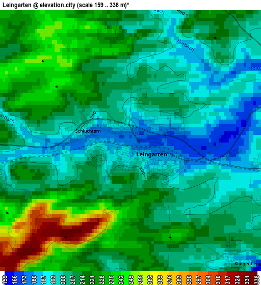
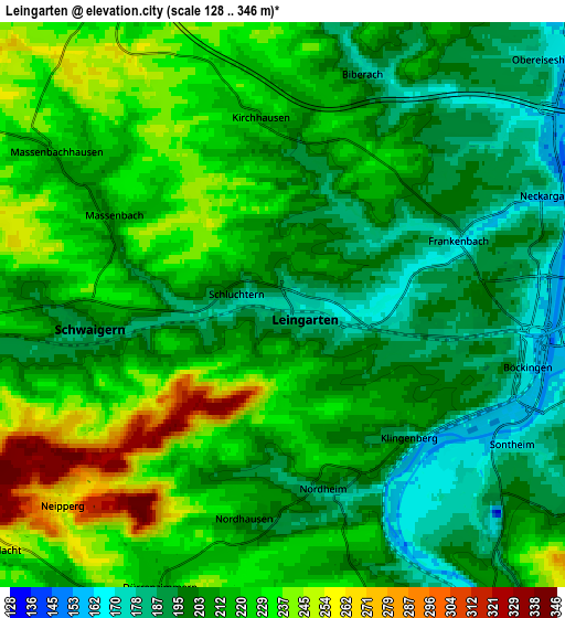
Below is the Elevation map of Leingarten, which displays elevation range with different colors. Scale of the first map is from 159 to 338 m (522 to 1109 ft) with average elevation of 212.8 meters (=698 ft) [note 1]
These maps also provides idea of topography and contour of this city, they are displayed at different zoom levels. More info about maps, scale and edge coordinates you can find below images.
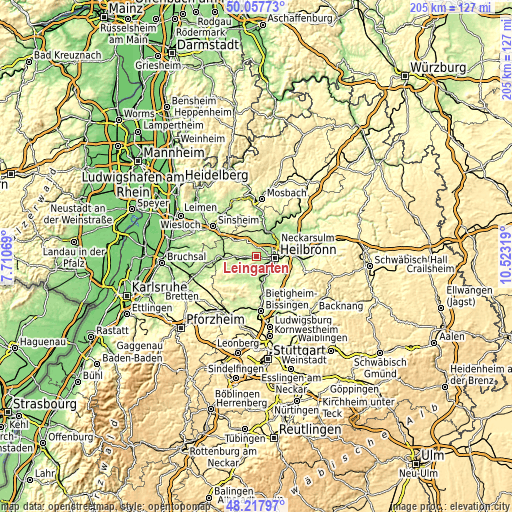
| \ | Map #1 | Map #2 | Topo.Map |
| Scale [m] | 159..338 m | 128..346 m | × |
| Scale [ft] | 522..1109 ft | 420..1135 ft | × |
| Average | 212.8 m = 698 ft | 212.9 m = 698 ft | × |
| Width | 6.39 km = 4 mi | 12.79 km = 7.9 mi | 204.6 km = 127.1 mi |
| Height | 6.39 km = 4 mi | 12.78 km = 7.9 mi | 204.5 km = 127.1 mi |
| ↑Max Latitude | 49.175128° | 49.203848° | 50.05773° |
| Latitude at center | 49.14639° | 49.14639° | 49.14639° |
| ↓Min Latitude | 49.117636° | 49.088865° | 48.21797° |
| ← Min Longitude | 9.072995° | 9.029049° | 7.71069° |
| Longitude center | 9.11694° | 9.11694° | 9.11694° |
| →Max Longitude | 9.160885° | 9.204831° | 10.52319° |
Nearby cities:
Cities around Leingarten sort by population:
• Heilbronn elevation 173 m
7.6 km,  95°
95°
• Neckarsulm 174 m
9.2 km,  58°
58°
• Brackenheim 202 m
8.5 km,  205°
205°
• Lauffen am Neckar 186 m
8.4 km,  165°
165°
• Schwaigern 202 m
4.5 km,  267°
267°
• Nordheim 181 m
4.3 km, 169°
• Bad Wimpfen 208 m
9.7 km,  17°
17°
• Flein 191 m
8.4 km,  125°
125°
• Gemmingen 212 m
9.9 km,  276°
276°
• Talheim 205 m
8.9 km,  141°
141°
• Untereisesheim 160 m
9.5 km,  40°
40°
• Massenbachhausen 210 m
6.4 km,  303°
303°
Multilingual:
 En español:
Leingarten elevación 171 m.
 En France:
Leingarten élévation 171 m.
 Auf Deutsch:
Leingarten höhe über dem Meeresspiegel ist 171 m.

Sources and notes:
- [note 1] Map square and city borders are not equal. Map elevation data is calculated only from area inside that square.
- [src 1] Elevation data from geonames database provided with same terms of usage.
- [src 2] The elevation map of Leingarten is generated using elevation data from NASA's 3 arcsec (90m) resolution SRTM data.
- [src 3] Base (background) map © OpenStreetMap contributors tiles are generated by Geofabrik and OpenTopoMap.
Copyright & License:
This Leingarten Elevation Map is licensed under CC BY-SA. You may reuse any part from this page, if you give a proper credit by linking to this URL:
 More info on terms of use page.