Dannstadt-Schauernheim elevation
Dannstadt-Schauernheim (Rheinland-Pfalz), Germany elevation is 97 meters and Dannstadt-Schauernheim elevation in feet is 318 ft above sea level [src 1]. Dannstadt-Schauernheim is a seat of a fourth-order administrative division (feature code) with elevation that is 161 meters (528 ft) smaller than average city elevation in Germany.
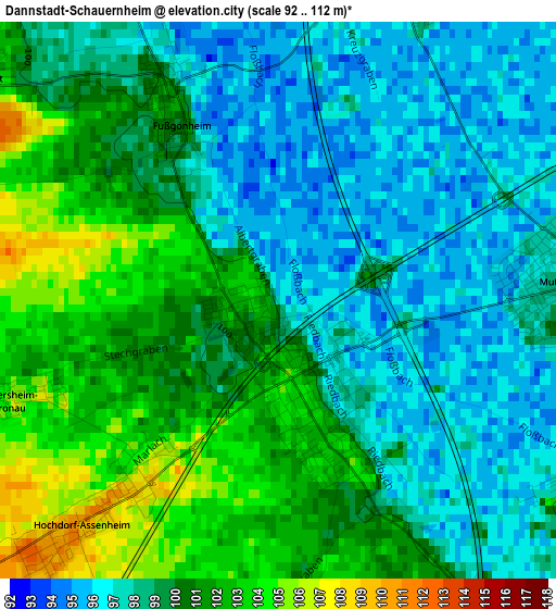
Below is the Elevation map of Dannstadt-Schauernheim, which displays elevation range with different colors. Scale of the first map is from 92 to 112 m (302 to 367 ft) with average elevation of 99.2 meters (=325 ft) [note 1]
These maps also provides idea of topography and contour of this city, they are displayed at different zoom levels. More info about maps, scale and edge coordinates you can find below images.
| \ | Map #1 | Map #2 | Topo.Map |
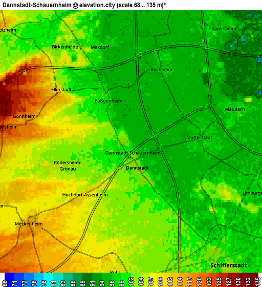
| Scale [m] | 92..112 m | 68..135 m | × |
| Scale [ft] | 302..367 ft | 223..443 ft | × |
| Average | 99.2 m = 325 ft | 101.9 m = 334 ft | × |
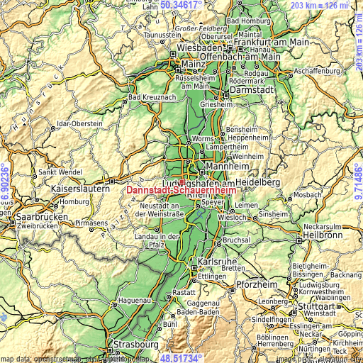
| Width | 6.35 km = 3.9 mi | 12.71 km = 7.9 mi | 203.3 km = 126.3 mi |
| Height | 6.35 km = 3.9 mi | 12.71 km = 7.9 mi | 203.3 km = 126.3 mi |
| ↑Max Latitude | 49.468847° | 49.497397° | 50.34617° |
| Latitude at center | 49.44028° | 49.44028° | 49.44028° |
| ↓Min Latitude | 49.411697° | 49.383097° | 48.51734° |
| ← Min Longitude | 8.264665° | 8.220719° | 6.90236° |
| Longitude center | 8.30861° | 8.30861° | 8.30861° |
| →Max Longitude | 8.352555° | 8.396501° | 9.71486° |
Nearby cities:
Cities around Dannstadt-Schauernheim sort by population:
• Mutterstadt elevation 99 m
3.4 km,  87°
87°
• Böhl-Iggelheim 108 m
6.6 km,  182°
182°
• Limburgerhof 99 m
6.3 km,  106°
106°
• Maxdorf 95 m
5.5 km,  347°
347°
• Meckenheim 114 m
6.4 km,  231°
231°
• Birkenheide 101 m
5.7 km,  323°
323°
• Hochdorf-Assenheim 111 m
3 km,  220°
220°
• Rödersheim-Gronau 107 m
3.6 km,  251°
251°
• Fußgönheim 102 m
2.6 km,  332°
332°
• Ellerstadt 114 m
4.3 km,  303°
303°
• Friedelsheim 123 m
6.2 km,  276°
276°
• Gönnheim 119 m
5.1 km, 279°
Multilingual:
 En español:
Dannstadt-Schauernheim elevación 97 m.
 En France:
Dannstadt-Schauernheim élévation 97 m.
 Auf Deutsch:
Dannstadt-Schauernheim höhe über dem Meeresspiegel ist 97 m.
 На русском:
Dannstadt-Schauernheim высота над уровнем моря 97 м
Sources and notes:
- [note 1] Map square and city borders are not equal. Map elevation data is calculated only from area inside that square.
- [src 1] Elevation data from geonames database provided with same terms of usage.
- [src 2] The elevation map of Dannstadt-Schauernheim is generated using elevation data from NASA's 3 arcsec (90m) resolution SRTM data.
- [src 3] Base (background) map © OpenStreetMap contributors tiles are generated by Geofabrik and OpenTopoMap.
Copyright & License:
This Dannstadt-Schauernheim Elevation Map is licensed under CC BY-SA. You may reuse any part from this page, if you give a proper credit by linking to this URL:
 More info on terms of use page.