Mohrkirch elevation
Mohrkirch (Schleswig-Holstein), Germany elevation is 27 meters and Mohrkirch elevation in feet is 89 ft above sea level [src 1]. Mohrkirch is a seat of a fourth-order administrative division (feature code) with elevation that is 231 meters (758 ft) smaller than average city elevation in Germany.
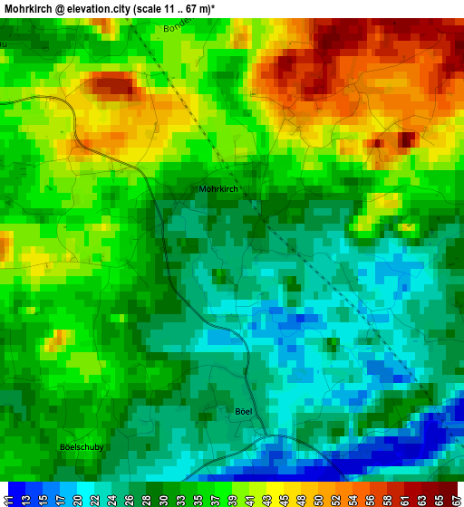
Below is the Elevation map of Mohrkirch, which displays elevation range with different colors. Scale of the first map is from 11 to 67 m (36 to 220 ft) with average elevation of 33.8 meters (=111 ft) [note 1]
These maps also provides idea of topography and contour of this city, they are displayed at different zoom levels. More info about maps, scale and edge coordinates you can find below images.
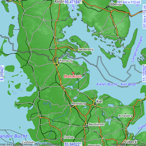
| \ | Map #1 | Topo.Map |
| Scale [m] | 11..67 m | × |
| Scale [ft] | 36..220 ft | × |
| Average | 33.8 m = 111 ft | × |
| Width | 5.65 km = 3.5 mi | 180.9 km = 112.4 mi |
| Height | 5.65 km = 3.5 mi | 180.8 km = 112.3 mi |
| ↑Max Latitude | 54.692077° | 55.47184° |
| Latitude at center | 54.66667° | 54.66667° |
| ↓Min Latitude | 54.641247° | 53.84522° |
| ← Min Longitude | 9.672725° | 8.31042° |
| Longitude center | 9.71667° | 9.71667° |
| →Max Longitude | 9.760615° | 11.12292° |
Nearby cities:
Cities around Mohrkirch sort by population:
• Kappeln elevation 12 m
13.8 km,  92°
92°
• Sörup 39 m
6.4 km,  329°
329°
• Süderbrarup 32 m
5.7 km,  130°
130°
• Satrup 38 m
7.7 km,  291°
291°
• Großsolt 41 m
13.4 km, 286°
• Schaalby 22 m
14 km,  202°
202°
• Sterup 39 m
6.8 km,  10°
10°
• Steinbergkirche 40 m
10.2 km,  16°
16°
• Quern 47 m
9.3 km,  0°
0°
• Tolk 33 m
10.9 km,  207°
207°
• Dollerup 29 m
12.6 km,  349°
349°
• Steinberg 15 m
11.9 km, 21°
Multilingual:
 En español:
Mohrkirch elevación 27 m.
 En France:
Mohrkirch élévation 27 m.
 Auf Deutsch:
Mohrkirch höhe über dem Meeresspiegel ist 27 m.

Sources and notes:
- [note 1] Map square and city borders are not equal. Map elevation data is calculated only from area inside that square.
- [src 1] Elevation data from geonames database provided with same terms of usage.
- [src 2] The elevation map of Mohrkirch is generated using elevation data from NASA's 3 arcsec (90m) resolution SRTM data.
- [src 3] Base (background) map © OpenStreetMap contributors tiles are generated by Geofabrik and OpenTopoMap.
Copyright & License:
This Mohrkirch Elevation Map is licensed under CC BY-SA. You may reuse any part from this page, if you give a proper credit by linking to this URL:
 More info on terms of use page.