Schondorf am Ammersee elevation
Schondorf am Ammersee (Bavaria, Upper Bavaria), Germany elevation is 555 meters and Schondorf am Ammersee elevation in feet is 1821 ft above sea level [src 1]. Schondorf am Ammersee is a populated place (feature code) with elevation that is 297 meters (974 ft) bigger than average city elevation in Germany.
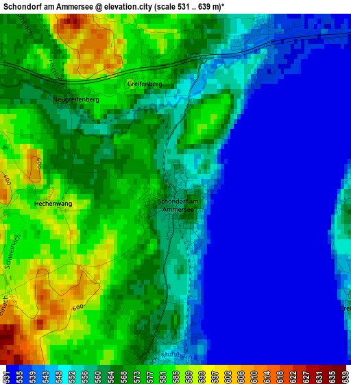
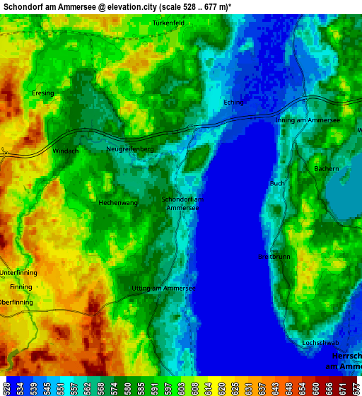
Below is the Elevation map of Schondorf am Ammersee, which displays elevation range with different colors. Scale of the first map is from 531 to 639 m (1742 to 2096 ft) with average elevation of 559.9 meters (=1837 ft) [note 1]
These maps also provides idea of topography and contour of this city, they are displayed at different zoom levels. More info about maps, scale and edge coordinates you can find below images.
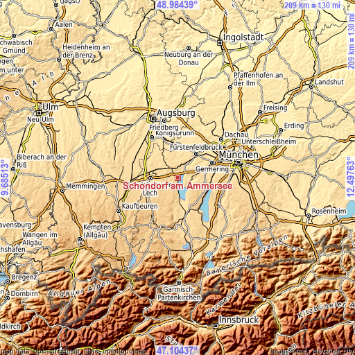
| \ | Map #1 | Map #2 | Topo.Map |
| Scale [m] | 531..639 m | 528..677 m | × |
| Scale [ft] | 1742..2096 ft | 1732..2221 ft | × |
| Average | 559.9 m = 1837 ft | 579.3 m = 1901 ft | × |
| Width | 6.53 km = 4.1 mi | 13.06 km = 8.1 mi | 209 km = 129.9 mi |
| Height | 6.53 km = 4.1 mi | 13.06 km = 8.1 mi | 209 km = 129.9 mi |
| ↑Max Latitude | 48.082327° | 48.111676° | 48.98439° |
| Latitude at center | 48.05296° | 48.05296° | 48.05296° |
| ↓Min Latitude | 48.023577° | 47.994177° | 47.10437° |
| ← Min Longitude | 11.047435° | 11.003489° | 9.68513° |
| Longitude center | 11.09138° | 11.09138° | 11.09138° |
| →Max Longitude | 11.135325° | 11.179271° | 12.49763° |
Nearby cities:
Cities around Schondorf am Ammersee sort by population:
• Herrsching am Ammersee elevation 551 m
8.7 km,  133°
133°
• Geltendorf 598 m
8.4 km,  328°
328°
• Wörthsee 585 m
8.5 km,  75°
75°
• Inning am Ammersee 553 m
5.2 km,  60°
60°
• Utting am Ammersee 561 m
3 km,  187°
187°
• Grafrath 562 m
9 km,  38°
38°
• Windach 579 m
4.6 km,  289°
289°
• Türkenfeld 603 m
5.9 km,  353°
353°
• Greifenberg 583 m
2 km,  343°
343°
• Eresing 600 m
6.3 km,  307°
307°
• Eching 541 m
3.4 km,  28°
28°
• Kottgeisering 539 m
7.7 km,  23°
23°
Multilingual:
 En español:
Schondorf am Ammersee elevación 555 m.
 En France:
Schondorf am Ammersee élévation 555 m.
 Auf Deutsch:
Schondorf am Ammersee höhe über dem Meeresspiegel ist 555 m.
 На русском:
Шондорф-ам-Аммерзее высота над уровнем моря 555 м
Sources and notes:
- [note 1] Map square and city borders are not equal. Map elevation data is calculated only from area inside that square.
- [src 1] Elevation data from geonames database provided with same terms of usage.
- [src 2] The elevation map of Schondorf am Ammersee is generated using elevation data from NASA's 3 arcsec (90m) resolution SRTM data.
- [src 3] Base (background) map © OpenStreetMap contributors tiles are generated by Geofabrik and OpenTopoMap.
Copyright & License:
This Schondorf am Ammersee Elevation Map is licensed under CC BY-SA. You may reuse any part from this page, if you give a proper credit by linking to this URL:
 More info on terms of use page.