Grafrath elevation
Grafrath (Bavaria, Upper Bavaria), Germany elevation is 562 meters and Grafrath elevation in feet is 1844 ft above sea level [src 1]. Grafrath is a seat of a fourth-order administrative division (feature code) with elevation that is 304 meters (997 ft) bigger than average city elevation in Germany.
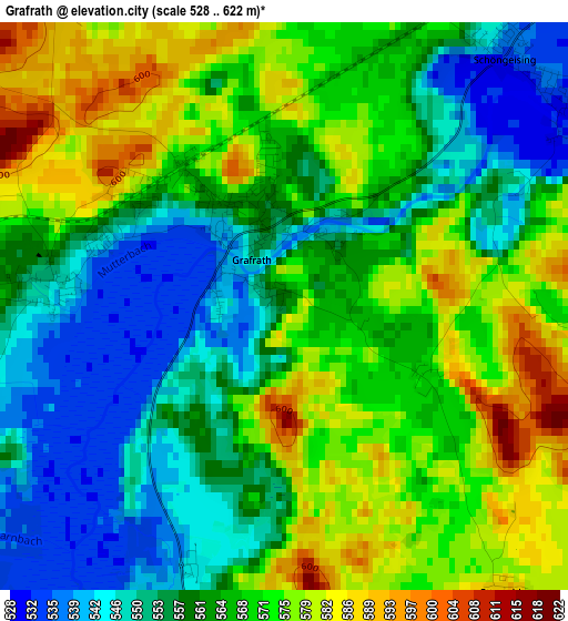
Below is the Elevation map of Grafrath, which displays elevation range with different colors. Scale of the first map is from 528 to 622 m (1732 to 2041 ft) with average elevation of 564.4 meters (=1852 ft) [note 1]
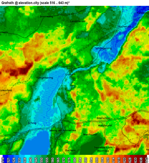
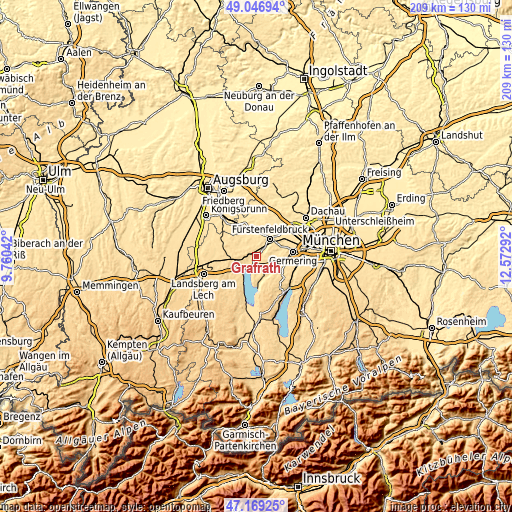
These maps also provides idea of topography and contour of this city, they are displayed at different zoom levels. More info about maps, scale and edge coordinates you can find below images.
| \ | Map #1 | Map #2 | Topo.Map |
| Scale [m] | 528..622 m | 516..643 m | × |
| Scale [ft] | 1732..2041 ft | 1693..2110 ft | × |
| Average | 564.4 m = 1852 ft | 571.4 m = 1875 ft | × |
| Width | 6.52 km = 4.1 mi | 13.05 km = 8.1 mi | 208.8 km = 129.7 mi |
| Height | 6.52 km = 4.1 mi | 13.05 km = 8.1 mi | 208.8 km = 129.7 mi |
| ↑Max Latitude | 48.146° | 48.175314° | 49.04694° |
| Latitude at center | 48.11667° | 48.11667° | 48.11667° |
| ↓Min Latitude | 48.087323° | 48.057959° | 47.16925° |
| ← Min Longitude | 11.122725° | 11.078779° | 9.76042° |
| Longitude center | 11.16667° | 11.16667° | 11.16667° |
| →Max Longitude | 11.210615° | 11.254561° | 12.57292° |
Nearby cities:
Cities around Grafrath sort by population:
• Weßling elevation 596 m
7.7 km,  127°
127°
• Wörthsee 585 m
5.6 km,  152°
152°
• Inning am Ammersee 553 m
4.6 km,  193°
193°
• Moorenweis 567 m
7.8 km,  303°
303°
• Türkenfeld 603 m
6.3 km,  258°
258°
• Greifenberg 583 m
8 km,  230°
230°
• Schöngeising 535 m
3.9 km,  45°
45°
• Eching 541 m
5.7 km,  224°
224°
• Adelshofen 564 m
8.3 km,  333°
333°
• Kottgeisering 539 m
2.5 km,  270°
270°
• Jesenwang 562 m
6.1 km,  336°
336°
• Landsberied 556 m
5.6 km,  0°
0°
Multilingual:
 En español:
Grafrath elevación 562 m.
 En France:
Grafrath élévation 562 m.
 Auf Deutsch:
Grafrath höhe über dem Meeresspiegel ist 562 m.

Sources and notes:
- [note 1] Map square and city borders are not equal. Map elevation data is calculated only from area inside that square.
- [src 1] Elevation data from geonames database provided with same terms of usage.
- [src 2] The elevation map of Grafrath is generated using elevation data from NASA's 3 arcsec (90m) resolution SRTM data.
- [src 3] Base (background) map © OpenStreetMap contributors tiles are generated by Geofabrik and OpenTopoMap.
Copyright & License:
This Grafrath Elevation Map is licensed under CC BY-SA. You may reuse any part from this page, if you give a proper credit by linking to this URL:
 More info on terms of use page.