Aalen elevation
Aalen (Baden-Württemberg, Regierungsbezirk Stuttgart), Germany elevation is 433 meters and Aalen elevation in feet is 1421 ft above sea level [src 1]. Aalen is a seat of a third-order administrative division (feature code) with elevation that is 175 meters (574 ft) bigger than average city elevation in Germany.
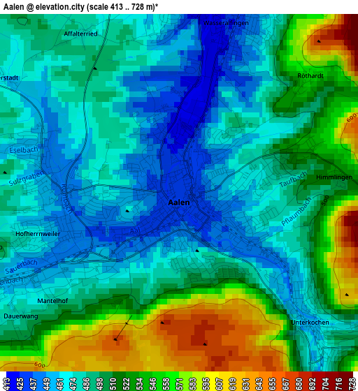
Below is the Elevation map of Aalen, which displays elevation range with different colors. Scale of the first map is from 413 to 728 m (1355 to 2388 ft) with average elevation of 501.3 meters (=1645 ft) [note 1]
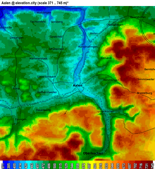
These maps also provides idea of topography and contour of this city, they are displayed at different zoom levels. More info about maps, scale and edge coordinates you can find below images.
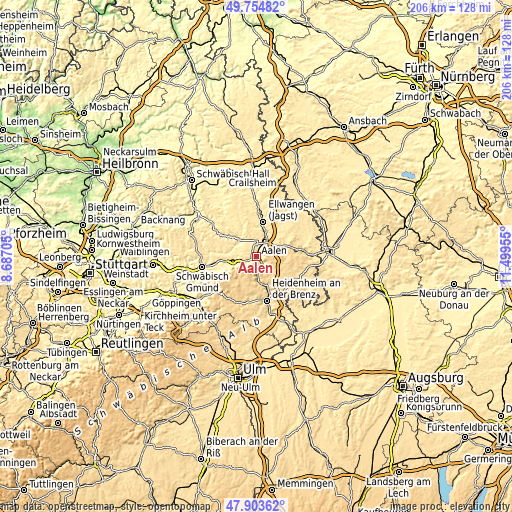
| \ | Map #1 | Map #2 | Topo.Map |
| Scale [m] | 413..728 m | 371..745 m | × |
| Scale [ft] | 1355..2388 ft | 1217..2444 ft | × |
| Average | 501.3 m = 1645 ft | 542.7 m = 1781 ft | × |
| Width | 6.43 km = 4 mi | 12.86 km = 8 mi | 205.8 km = 127.9 mi |
| Height | 6.43 km = 4 mi | 12.86 km = 8 mi | 205.8 km = 127.9 mi |
| ↑Max Latitude | 48.866686° | 48.895586° | 49.75482° |
| Latitude at center | 48.83777° | 48.83777° | 48.83777° |
| ↓Min Latitude | 48.808837° | 48.779888° | 47.90362° |
| ← Min Longitude | 10.049355° | 10.005409° | 8.68705° |
| Longitude center | 10.0933° | 10.0933° | 10.0933° |
| →Max Longitude | 10.137245° | 10.181191° | 11.49955° |
Nearby cities:
Cities around Aalen sort by population:
• Heubach elevation 452 m
12.7 km,  246°
246°
• Oberkochen 495 m
6.1 km,  171°
171°
• Königsbronn 503 m
10.6 km, 172°
• Abtsgmünd 374 m
9.2 km,  313°
313°
• Essingen 503 m
5.8 km,  235°
235°
• Westhausen 487 m
8.3 km,  52°
52°
• Hüttlingen 407 m
6.1 km,  5°
5°
• Lauchheim 491 m
11.5 km,  71°
71°
• Mögglingen 412 m
9.7 km,  260°
260°
• Neuler 505 m
10.2 km,  349°
349°
• Bartholomä 646 m
12.2 km,  219°
219°
• Heuchlingen 388 m
11 km,  278°
278°
Multilingual:
 En español:
Aalen elevación 433 m.
 En France:
Aalen élévation 433 m.


Sources and notes:
- [note 1] Map square and city borders are not equal. Map elevation data is calculated only from area inside that square.
- [src 1] Elevation data from geonames database provided with same terms of usage.
- [src 2] The elevation map of Aalen is generated using elevation data from NASA's 3 arcsec (90m) resolution SRTM data.
- [src 3] Base (background) map © OpenStreetMap contributors tiles are generated by Geofabrik and OpenTopoMap.
Copyright & License:
This Aalen Elevation Map is licensed under CC BY-SA. You may reuse any part from this page, if you give a proper credit by linking to this URL:
 More info on terms of use page.