Affalterbach elevation
Affalterbach (Baden-Württemberg, Regierungsbezirk Stuttgart), Germany elevation is 312 meters and Affalterbach elevation in feet is 1024 ft above sea level [src 1]. Affalterbach is a seat of a fourth-order administrative division (feature code) with elevation that is 54 meters (177 ft) bigger than average city elevation in Germany.
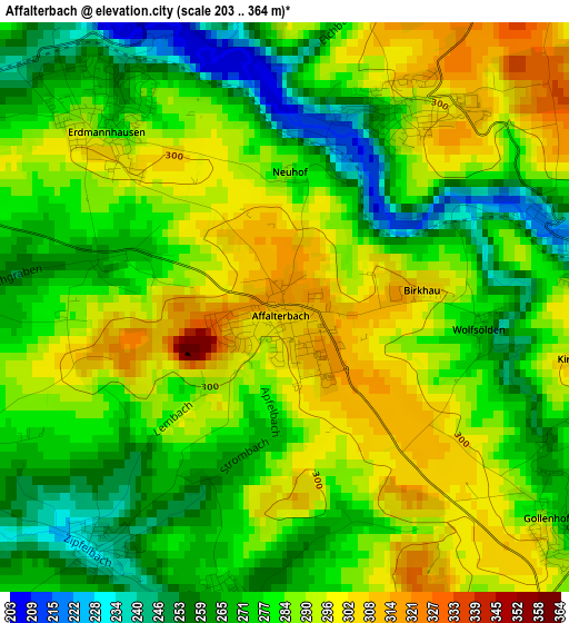
Below is the Elevation map of Affalterbach, which displays elevation range with different colors. Scale of the first map is from 203 to 364 m (666 to 1194 ft) with average elevation of 281.6 meters (=924 ft) [note 1]
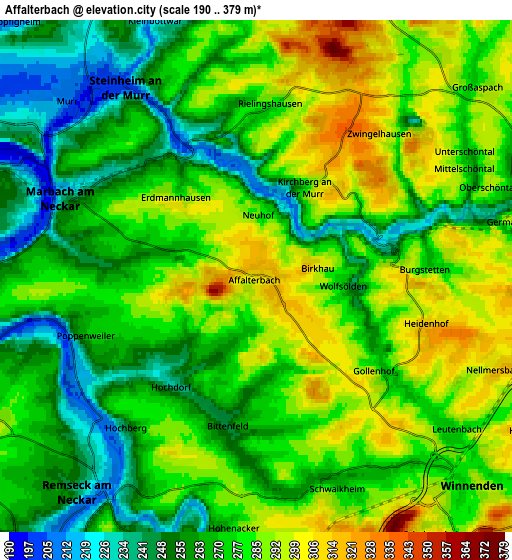
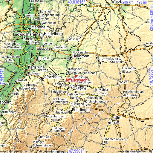
These maps also provides idea of topography and contour of this city, they are displayed at different zoom levels. More info about maps, scale and edge coordinates you can find below images.
| \ | Map #1 | Map #2 | Topo.Map |
| Scale [m] | 203..364 m | 190..379 m | × |
| Scale [ft] | 666..1194 ft | 623..1243 ft | × |
| Average | 281.6 m = 924 ft | 274.6 m = 901 ft | × |
| Width | 6.42 km = 4 mi | 12.84 km = 8 mi | 205.5 km = 127.7 mi |
| Height | 6.42 km = 4 mi | 12.84 km = 8 mi | 205.5 km = 127.7 mi |
| ↑Max Latitude | 48.951537° | 48.980388° | 49.83815° |
| Latitude at center | 48.92267° | 48.92267° | 48.92267° |
| ↓Min Latitude | 48.893786° | 48.864886° | 47.9901° |
| ← Min Longitude | 9.279675° | 9.235729° | 7.91737° |
| Longitude center | 9.32362° | 9.32362° | 9.32362° |
| →Max Longitude | 9.367565° | 9.411511° | 10.72987° |
Nearby cities:
Cities around Affalterbach sort by population:
• Winnenden elevation 293 m
7.6 km,  133°
133°
• Marbach am Neckar 242 m
5 km,  292°
292°
• Steinheim am der Murr 212 m
6.1 km,  326°
326°
• Leutenbach 278 m
6.4 km, 127°
• Schwaikheim 267 m
5.4 km,  159°
159°
• Aspach 280 m
7.4 km,  48°
48°
• Murr 207 m
6.4 km,  312°
312°
• Mittelschöntal 282 m
5.8 km,  63°
63°
• Benningen am Neckar 209 m
6.5 km, 294°
• Erdmannhausen 278 m
3 km,  317°
317°
• Kirchberg an der Murr 284 m
2.6 km,  29°
29°
• Burgstetten 255 m
3.6 km,  80°
80°
Multilingual:
 En español:
Affalterbach elevación 312 m.
 En France:
Affalterbach élévation 312 m.
 Auf Deutsch:
Affalterbach höhe über dem Meeresspiegel ist 312 m.

Sources and notes:
- [note 1] Map square and city borders are not equal. Map elevation data is calculated only from area inside that square.
- [src 1] Elevation data from geonames database provided with same terms of usage.
- [src 2] The elevation map of Affalterbach is generated using elevation data from NASA's 3 arcsec (90m) resolution SRTM data.
- [src 3] Base (background) map © OpenStreetMap contributors tiles are generated by Geofabrik and OpenTopoMap.
Copyright & License:
This Affalterbach Elevation Map is licensed under CC BY-SA. You may reuse any part from this page, if you give a proper credit by linking to this URL:
 More info on terms of use page.