Mittelschöntal elevation
Mittelschöntal (Baden-Württemberg, Regierungsbezirk Stuttgart), Germany elevation is 282 meters and Mittelschöntal elevation in feet is 925 ft above sea level [src 1]. Mittelschöntal is a populated place (feature code) with elevation that is 24 meters (79 ft) bigger than average city elevation in Germany.
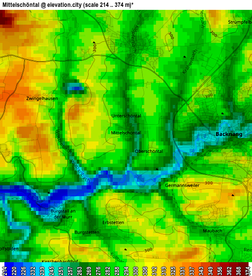
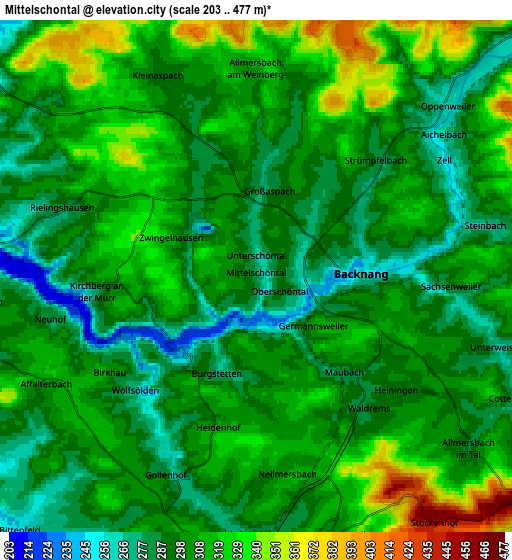
Below is the Elevation map of Mittelschöntal, which displays elevation range with different colors. Scale of the first map is from 214 to 374 m (702 to 1227 ft) with average elevation of 289.8 meters (=951 ft) [note 1]
These maps also provides idea of topography and contour of this city, they are displayed at different zoom levels. More info about maps, scale and edge coordinates you can find below images.
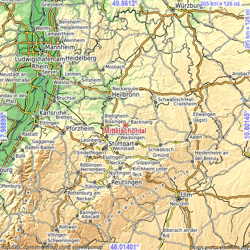
| \ | Map #1 | Map #2 | Topo.Map |
| Scale [m] | 214..374 m | 203..477 m | × |
| Scale [ft] | 702..1227 ft | 666..1565 ft | × |
| Average | 289.8 m = 951 ft | 303.7 m = 996 ft | × |
| Width | 6.42 km = 4 mi | 12.84 km = 8 mi | 205.4 km = 127.6 mi |
| Height | 6.42 km = 4 mi | 12.84 km = 8 mi | 205.4 km = 127.6 mi |
| ↑Max Latitude | 48.975004° | 49.00384° | 49.8612° |
| Latitude at center | 48.94615° | 48.94615° | 48.94615° |
| ↓Min Latitude | 48.91728° | 48.888393° | 48.01401° |
| ← Min Longitude | 9.351255° | 9.307309° | 7.98895° |
| Longitude center | 9.3952° | 9.3952° | 9.3952° |
| →Max Longitude | 9.439145° | 9.483091° | 10.80145° |
Nearby cities:
Cities around Mittelschöntal sort by population:
• Backnang elevation 245 m
3.1 km,  87°
87°
• Winnenden 293 m
7.8 km,  178°
178°
• Steinheim am der Murr 212 m
9 km,  285°
285°
• Leutenbach 278 m
6.5 km, 181°
• Schwaikheim 267 m
8.3 km,  203°
203°
• Aspach 280 m
2.3 km,  8°
8°
• Allmersbach im Tal 287 m
6.9 km,  129°
129°
• Erdmannhausen 278 m
7.2 km,  266°
266°
• Affalterbach 312 m
5.8 km,  243°
243°
• Oppenweiler 264 m
6.2 km,  48°
48°
• Kirchberg an der Murr 284 m
4 km,  264°
264°
• Burgstetten 255 m
2.6 km,  219°
219°
Multilingual:
 En español:
Mittelschöntal elevación 282 m.
 En France:
Mittelschöntal élévation 282 m.
 Auf Deutsch:
Mittelschöntal höhe über dem Meeresspiegel ist 282 m.

Sources and notes:
- [note 1] Map square and city borders are not equal. Map elevation data is calculated only from area inside that square.
- [src 1] Elevation data from geonames database provided with same terms of usage.
- [src 2] The elevation map of Mittelschöntal is generated using elevation data from NASA's 3 arcsec (90m) resolution SRTM data.
- [src 3] Base (background) map © OpenStreetMap contributors tiles are generated by Geofabrik and OpenTopoMap.
Copyright & License:
This Mittelschöntal Elevation Map is licensed under CC BY-SA. You may reuse any part from this page, if you give a proper credit by linking to this URL:
 More info on terms of use page.