Bad Alexandersbad elevation
Bad Alexandersbad (Bavaria, Upper Franconia), Germany elevation is 580 meters and Bad Alexandersbad elevation in feet is 1903 ft above sea level [src 1]. Bad Alexandersbad is a seat of a fourth-order administrative division (feature code) with elevation that is 322 meters (1056 ft) bigger than average city elevation in Germany.
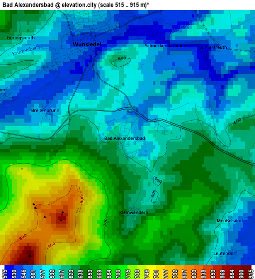
Below is the Elevation map of Bad Alexandersbad, which displays elevation range with different colors. Scale of the first map is from 515 to 915 m (1690 to 3002 ft) with average elevation of 622.7 meters (=2043 ft) [note 1]
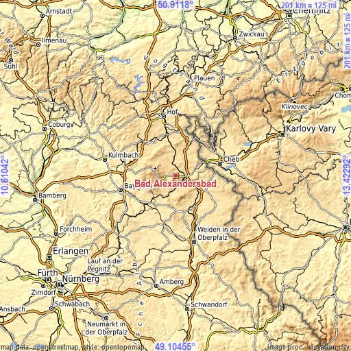
These maps also provides idea of topography and contour of this city, they are displayed at different zoom levels. More info about maps, scale and edge coordinates you can find below images.
| \ | Map #1 | Topo.Map |
| Scale [m] | 515..915 m | × |
| Scale [ft] | 1690..3002 ft | × |
| Average | 622.7 m = 2043 ft | × |
| Width | 6.28 km = 3.9 mi | 200.9 km = 124.8 mi |
| Height | 6.28 km = 3.9 mi | 200.9 km = 124.8 mi |
| ↑Max Latitude | 50.044899° | 50.9118° |
| Latitude at center | 50.01667° | 50.01667° |
| ↓Min Latitude | 49.988424° | 49.10455° |
| ← Min Longitude | 11.972725° | 10.61042° |
| Longitude center | 12.01667° | 12.01667° |
| →Max Longitude | 12.060615° | 13.42292° |
Nearby cities:
Cities around Bad Alexandersbad sort by population:
• Marktredwitz elevation 539 m
5.1 km,  105°
105°
• Wunsiedel 545 m
2.7 km,  339°
339°
• Waldershof 557 m
5.1 km,  139°
139°
• Tröstau 552 m
4.8 km,  270°
270°
• Röslau 563 m
7.8 km, 342°
• Thiersheim 539 m
10.3 km,  49°
49°
• Neusorg 561 m
9.9 km,  201°
201°
• Nagel 592 m
8.1 km,  242°
242°
• Pullenreuth 544 m
9.3 km,  187°
187°
• Ebnath 569 m
9.5 km,  218°
218°
• Höchstädt bei Thiersheim 570 m
10.7 km,  28°
28°
• Brand 590 m
9.9 km,  230°
230°
Multilingual:
 En español:
Bad Alexandersbad elevación 580 m.
 En France:
Bad Alexandersbad élévation 580 m.
 Auf Deutsch:
Bad Alexandersbad höhe über dem Meeresspiegel ist 580 m.
 На русском:
Бад-Александерсбад высота над уровнем моря 580 м
Sources and notes:
- [note 1] Map square and city borders are not equal. Map elevation data is calculated only from area inside that square.
- [src 1] Elevation data from geonames database provided with same terms of usage.
- [src 2] The elevation map of Bad Alexandersbad is generated using elevation data from NASA's 3 arcsec (90m) resolution SRTM data.
- [src 3] Base (background) map © OpenStreetMap contributors tiles are generated by Geofabrik and OpenTopoMap.
Copyright & License:
This Bad Alexandersbad Elevation Map is licensed under CC BY-SA. You may reuse any part from this page, if you give a proper credit by linking to this URL:
 More info on terms of use page.