Alsenz elevation
Alsenz (Rheinland-Pfalz), Germany elevation is 176 meters and Alsenz elevation in feet is 577 ft above sea level [src 1]. Alsenz is a seat of a fourth-order administrative division (feature code) with elevation that is 82 meters (269 ft) smaller than average city elevation in Germany.
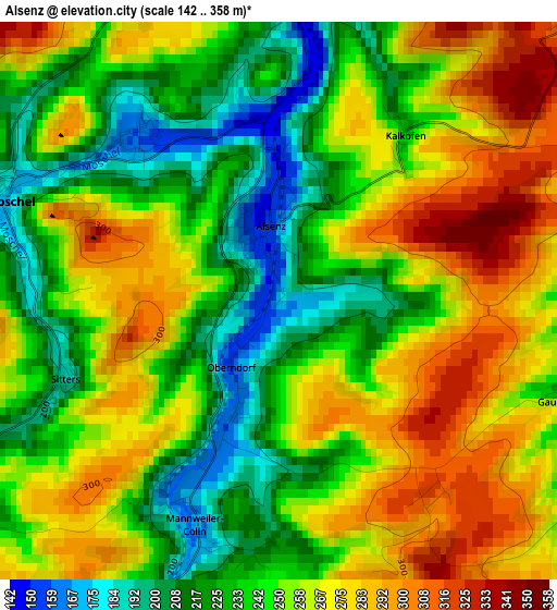
Below is the Elevation map of Alsenz, which displays elevation range with different colors. Scale of the first map is from 142 to 358 m (466 to 1175 ft) with average elevation of 252 meters (=827 ft) [note 1]
These maps also provides idea of topography and contour of this city, they are displayed at different zoom levels. More info about maps, scale and edge coordinates you can find below images.
| \ | Map #1 | Topo.Map |
| Scale [m] | 142..358 m | × |
| Scale [ft] | 466..1175 ft | × |
| Average | 252 m = 827 ft | × |
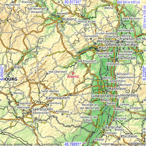
| Width | 6.32 km = 3.9 mi | 202.2 km = 125.6 mi |
| Height | 6.32 km = 3.9 mi | 202.2 km = 125.6 mi |
| ↑Max Latitude | 49.745075° | 50.61741° |
| Latitude at center | 49.71667° | 49.71667° |
| ↓Min Latitude | 49.688248° | 48.79891° |
| ← Min Longitude | 7.772725° | 6.41042° |
| Longitude center | 7.81667° | 7.81667° |
| →Max Longitude | 7.860615° | 9.22292° |
Nearby cities:
Cities around Alsenz sort by population:
• Rockenhausen elevation 204 m
9.7 km,  178°
178°
• Bad Münster am Stein-Ebernburg 125 m
10.8 km,  10°
10°
• Meisenheim 169 m
10.8 km,  264°
264°
• Odernheim 145 m
9.7 km,  303°
303°
• Feilbingert 304 m
5.7 km,  347°
347°
• Staudernheim 141 m
11.4 km,  306°
306°
• Fürfeld 219 m
8.7 km,  38°
38°
• Norheim 130 m
10.5 km,  359°
359°
• Hüffelsheim 214 m
11.2 km, 353°
• Obermoschel 184 m
3.4 km,  291°
291°
• Kriegsfeld 341 m
7.2 km,  95°
95°
• Frei-Laubersheim 178 m
11 km,  32°
32°
Multilingual:
 En español:
Alsenz elevación 176 m.
 En France:
Alsenz élévation 176 m.


Sources and notes:
- [note 1] Map square and city borders are not equal. Map elevation data is calculated only from area inside that square.
- [src 1] Elevation data from geonames database provided with same terms of usage.
- [src 2] The elevation map of Alsenz is generated using elevation data from NASA's 3 arcsec (90m) resolution SRTM data.
- [src 3] Base (background) map © OpenStreetMap contributors tiles are generated by Geofabrik and OpenTopoMap.
Copyright & License:
This Alsenz Elevation Map is licensed under CC BY-SA. You may reuse any part from this page, if you give a proper credit by linking to this URL:
 More info on terms of use page.