Hüffelsheim elevation
Hüffelsheim (Rheinland-Pfalz), Germany elevation is 214 meters and Hüffelsheim elevation in feet is 702 ft above sea level [src 1]. Hüffelsheim is a seat of a fourth-order administrative division (feature code) with elevation that is 44 meters (144 ft) smaller than average city elevation in Germany.
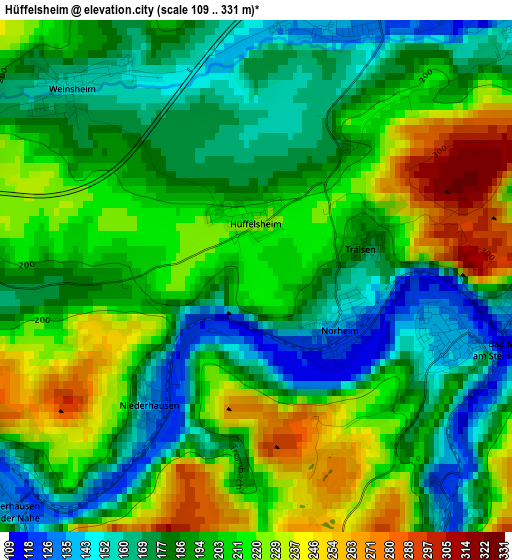
Below is the Elevation map of Hüffelsheim, which displays elevation range with different colors. Scale of the first map is from 109 to 331 m (358 to 1086 ft) with average elevation of 197.1 meters (=647 ft) [note 1]
These maps also provides idea of topography and contour of this city, they are displayed at different zoom levels. More info about maps, scale and edge coordinates you can find below images.
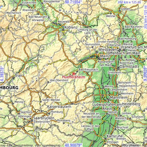
| \ | Map #1 | Topo.Map |
| Scale [m] | 109..331 m | × |
| Scale [ft] | 358..1086 ft | × |
| Average | 197.1 m = 647 ft | × |
| Width | 6.31 km = 3.9 mi | 201.8 km = 125.4 mi |
| Height | 6.31 km = 3.9 mi | 201.8 km = 125.4 mi |
| ↑Max Latitude | 49.845017° | 50.71554° |
| Latitude at center | 49.81667° | 49.81667° |
| ↓Min Latitude | 49.788307° | 48.90079° |
| ← Min Longitude | 7.756055° | 6.39375° |
| Longitude center | 7.8° | 7.8° |
| →Max Longitude | 7.843945° | 9.20625° |
Nearby cities:
Cities around Hüffelsheim sort by population:
• Bad Kreuznach elevation 109 m
5.5 km,  60°
60°
• Bad Münster am Stein-Ebernburg 125 m
3.3 km,  99°
99°
• Hargesheim 192 m
5.5 km,  22°
22°
• Rüdesheim 134 m
3.4 km, 18°
• Roxheim 159 m
5.3 km,  7°
7°
• Waldböckelheim 194 m
6 km,  270°
270°
• Hackenheim 180 m
7.2 km,  82°
82°
• Weinsheim 178 m
3 km,  307°
307°
• Feilbingert 304 m
5.6 km,  180°
180°
• Norheim 130 m
1.2 km,  121°
121°
• Frei-Laubersheim 178 m
7.4 km, 104°
• Gutenberg 238 m
7.4 km,  0°
0°
Multilingual:
 En español:
Hüffelsheim elevación 214 m.
 En France:
Hüffelsheim élévation 214 m.
 Auf Deutsch:
Hüffelsheim höhe über dem Meeresspiegel ist 214 m.

Sources and notes:
- [note 1] Map square and city borders are not equal. Map elevation data is calculated only from area inside that square.
- [src 1] Elevation data from geonames database provided with same terms of usage.
- [src 2] The elevation map of Hüffelsheim is generated using elevation data from NASA's 3 arcsec (90m) resolution SRTM data.
- [src 3] Base (background) map © OpenStreetMap contributors tiles are generated by Geofabrik and OpenTopoMap.
Copyright & License:
This Hüffelsheim Elevation Map is licensed under CC BY-SA. You may reuse any part from this page, if you give a proper credit by linking to this URL:
 More info on terms of use page.