Altenstadt elevation
Altenstadt (Hesse, Regierungsbezirk Darmstadt), Germany elevation is 133 meters and Altenstadt elevation in feet is 436 ft above sea level [src 1]. Altenstadt is a seat of a fourth-order administrative division (feature code) with elevation that is 125 meters (410 ft) smaller than average city elevation in Germany.
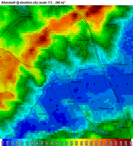
Below is the Elevation map of Altenstadt, which displays elevation range with different colors. Scale of the first map is from 113 to 240 m (371 to 787 ft) with average elevation of 153.1 meters (=502 ft) [note 1]
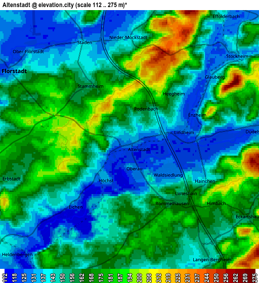
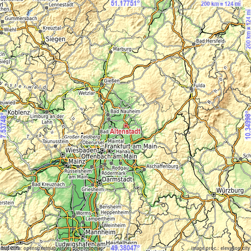
These maps also provides idea of topography and contour of this city, they are displayed at different zoom levels. More info about maps, scale and edge coordinates you can find below images.
| \ | Map #1 | Map #2 | Topo.Map |
| Scale [m] | 113..240 m | 112..275 m | × |
| Scale [ft] | 371..787 ft | 367..902 ft | × |
| Average | 153.1 m = 502 ft | 158.1 m = 519 ft | × |
| Width | 6.24 km = 3.9 mi | 12.49 km = 7.8 mi | 199.8 km = 124.1 mi |
| Height | 6.24 km = 3.9 mi | 12.49 km = 7.8 mi | 199.8 km = 124.1 mi |
| ↑Max Latitude | 50.31554° | 50.343593° | 51.17751° |
| Latitude at center | 50.28747° | 50.28747° | 50.28747° |
| ↓Min Latitude | 50.259383° | 50.23128° | 49.38047° |
| ← Min Longitude | 8.899785° | 8.855839° | 7.53748° |
| Longitude center | 8.94373° | 8.94373° | 8.94373° |
| →Max Longitude | 8.987675° | 9.031621° | 10.34998° |
Nearby cities:
Cities around Altenstadt sort by population:
• Karben elevation 118 m
13.8 km,  242°
242°
• Büdingen 136 m
11.9 km,  88°
88°
• Bruchköbel 116 m
12.2 km,  186°
186°
• Nidderau 125 m
7.7 km,  224°
224°
• Ortenberg 150 m
11 km,  46°
46°
• Florstadt 136 m
6.4 km,  300°
300°
• Reichelsheim 128 m
9.1 km,  327°
327°
• Echzell 131 m
12 km,  340°
340°
• Ranstadt 137 m
8.3 km,  20°
20°
• Hammersbach 135 m
8.4 km,  160°
160°
• Glauburg 131 m
5.1 km, 50°
• Melbach 153 m
14 km,  316°
316°
Multilingual:
 En español:
Altenstadt elevación 133 m.
 En France:
Altenstadt élévation 133 m.
 Auf Deutsch:
Altenstadt höhe über dem Meeresspiegel ist 133 m.

Sources and notes:
- [note 1] Map square and city borders are not equal. Map elevation data is calculated only from area inside that square.
- [src 1] Elevation data from geonames database provided with same terms of usage.
- [src 2] The elevation map of Altenstadt is generated using elevation data from NASA's 3 arcsec (90m) resolution SRTM data.
- [src 3] Base (background) map © OpenStreetMap contributors tiles are generated by Geofabrik and OpenTopoMap.
Copyright & License:
This Altenstadt Elevation Map is licensed under CC BY-SA. You may reuse any part from this page, if you give a proper credit by linking to this URL:
 More info on terms of use page.