Altusried elevation
Altusried (Bavaria, Swabia), Germany elevation is 721 meters and Altusried elevation in feet is 2365 ft above sea level [src 1]. Altusried is a populated place (feature code) with elevation that is 463 meters (1519 ft) bigger than average city elevation in Germany.
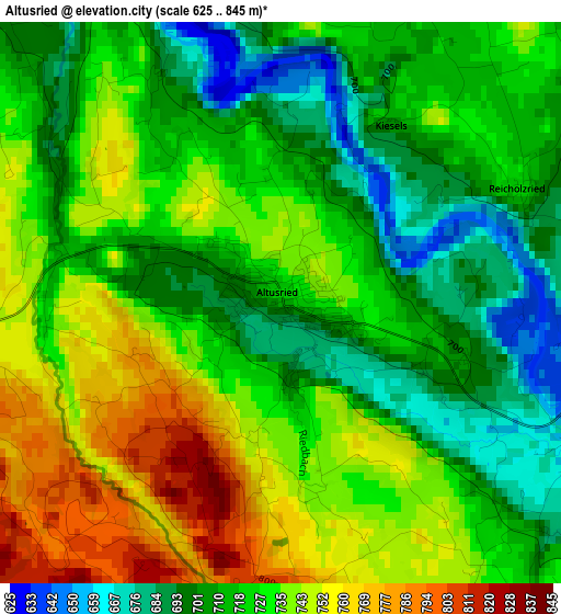
Below is the Elevation map of Altusried, which displays elevation range with different colors. Scale of the first map is from 625 to 845 m (2051 to 2772 ft) with average elevation of 724.8 meters (=2378 ft) [note 1]
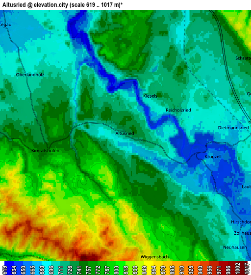
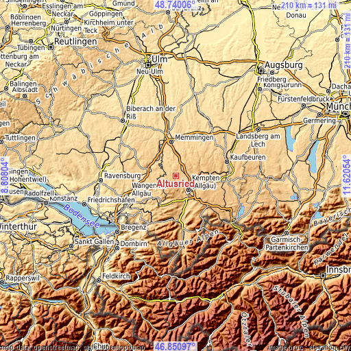
These maps also provides idea of topography and contour of this city, they are displayed at different zoom levels. More info about maps, scale and edge coordinates you can find below images.
| \ | Map #1 | Map #2 | Topo.Map |
| Scale [m] | 625..845 m | 619..1017 m | × |
| Scale [ft] | 2051..2772 ft | 2031..3337 ft | × |
| Average | 724.8 m = 2378 ft | 743.9 m = 2441 ft | × |
| Width | 6.56 km = 4.1 mi | 13.13 km = 8.2 mi | 210 km = 130.5 mi |
| Height | 6.56 km = 4.1 mi | 13.13 km = 8.2 mi | 210 km = 130.5 mi |
| ↑Max Latitude | 47.833608° | 47.8631° | 48.74006° |
| Latitude at center | 47.8041° | 47.8041° | 47.8041° |
| ↓Min Latitude | 47.774575° | 47.745033° | 46.85097° |
| ← Min Longitude | 10.170345° | 10.126399° | 8.80804° |
| Longitude center | 10.21429° | 10.21429° | 10.21429° |
| →Max Longitude | 10.258235° | 10.302181° | 11.62054° |
Nearby cities:
Cities around Altusried sort by population:
• Kempten (Allgäu) elevation 681 m
11.4 km,  139°
139°
• Dietmannsried 680 m
5.6 km,  85°
85°
• Wiggensbach 853 m
6.4 km,  169°
169°
• Buchenberg 892 m
12.2 km, 171°
• Haldenwang 766 m
10.1 km, 92°
• Lauben 675 m
6.8 km,  109°
109°
• Legau 670 m
8.6 km,  312°
312°
• Neuburg 740 m
11.2 km, 109°
• Wolfertschwenden 679 m
10.7 km,  21°
21°
• Woringen 638 m
12.6 km,  355°
355°
• Kronburg 702 m
11.9 km,  339°
339°
• Lautrach 635 m
12.7 km,  325°
325°
Multilingual:
 En español:
Altusried elevación 721 m.
 En France:
Altusried élévation 721 m.
 Auf Deutsch:
Altusried höhe über dem Meeresspiegel ist 721 m.

Sources and notes:
- [note 1] Map square and city borders are not equal. Map elevation data is calculated only from area inside that square.
- [src 1] Elevation data from geonames database provided with same terms of usage.
- [src 2] The elevation map of Altusried is generated using elevation data from NASA's 3 arcsec (90m) resolution SRTM data.
- [src 3] Base (background) map © OpenStreetMap contributors tiles are generated by Geofabrik and OpenTopoMap.
Copyright & License:
This Altusried Elevation Map is licensed under CC BY-SA. You may reuse any part from this page, if you give a proper credit by linking to this URL:
 More info on terms of use page.