Argenthal elevation
Argenthal (Rheinland-Pfalz), Germany elevation is 485 meters and Argenthal elevation in feet is 1591 ft above sea level [src 1]. Argenthal is a seat of a fourth-order administrative division (feature code) with elevation that is 227 meters (745 ft) bigger than average city elevation in Germany.
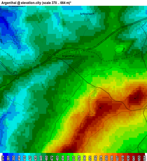
Below is the Elevation map of Argenthal, which displays elevation range with different colors. Scale of the first map is from 370 to 664 m (1214 to 2178 ft) with average elevation of 486.4 meters (=1596 ft) [note 1]
These maps also provides idea of topography and contour of this city, they are displayed at different zoom levels. More info about maps, scale and edge coordinates you can find below images.
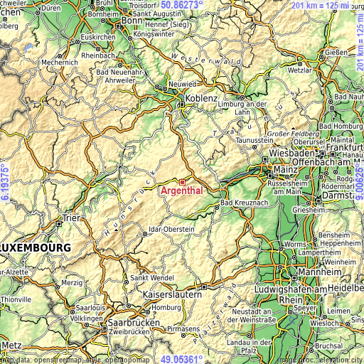
| \ | Map #1 | Topo.Map |
| Scale [m] | 370..664 m | × |
| Scale [ft] | 1214..2178 ft | × |
| Average | 486.4 m = 1596 ft | × |
| Width | 6.29 km = 3.9 mi | 201.2 km = 125 mi |
| Height | 6.29 km = 3.9 mi | 201.1 km = 125 mi |
| ↑Max Latitude | 49.994929° | 50.86273° |
| Latitude at center | 49.96667° | 49.96667° |
| ↓Min Latitude | 49.938395° | 49.05361° |
| ← Min Longitude | 7.556055° | 6.19375° |
| Longitude center | 7.6° | 7.6° |
| →Max Longitude | 7.643945° | 9.00625° |
Nearby cities:
Cities around Argenthal sort by population:
• Simmern elevation 333 m
5.7 km,  287°
287°
• Kastellaun 413 m
16.1 km,  315°
315°
• Rheinböllen 396 m
7.2 km,  46°
46°
• Kirchberg 435 m
14 km,  259°
259°
• Waldalgesheim 291 m
16.8 km,  96°
96°
• Bacharach 86 m
15.8 km, 50°
• Wallhausen 261 m
15.1 km,  127°
127°
• Bell 434 m
16.9 km,  308°
308°
• Seibersbach 433 m
8.3 km,  90°
90°
• Gemünden 283 m
11.9 km,  227°
227°
• Spabrücken 340 m
11.2 km, 131°
• Bockenau 238 m
16 km,  158°
158°
Multilingual:
 En español:
Argenthal elevación 485 m.
 En France:
Argenthal élévation 485 m.
 Auf Deutsch:
Argenthal höhe über dem Meeresspiegel ist 485 m.

Sources and notes:
- [note 1] Map square and city borders are not equal. Map elevation data is calculated only from area inside that square.
- [src 1] Elevation data from geonames database provided with same terms of usage.
- [src 2] The elevation map of Argenthal is generated using elevation data from NASA's 3 arcsec (90m) resolution SRTM data.
- [src 3] Base (background) map © OpenStreetMap contributors tiles are generated by Geofabrik and OpenTopoMap.
Copyright & License:
This Argenthal Elevation Map is licensed under CC BY-SA. You may reuse any part from this page, if you give a proper credit by linking to this URL:
 More info on terms of use page.