Ascha elevation
Ascha (Bavaria, Lower Bavaria), Germany elevation is 336 meters and Ascha elevation in feet is 1102 ft above sea level [src 1]. Ascha is a seat of a fourth-order administrative division (feature code) with elevation that is 78 meters (256 ft) bigger than average city elevation in Germany.
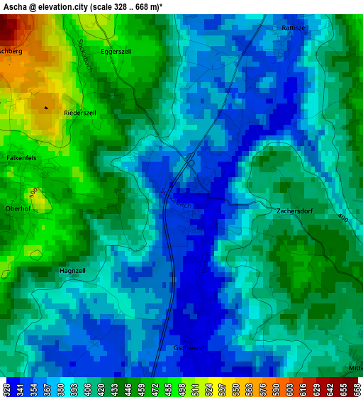
Below is the Elevation map of Ascha, which displays elevation range with different colors. Scale of the first map is from 328 to 668 m (1076 to 2192 ft) with average elevation of 411.6 meters (=1350 ft) [note 1]
These maps also provides idea of topography and contour of this city, they are displayed at different zoom levels. More info about maps, scale and edge coordinates you can find below images.
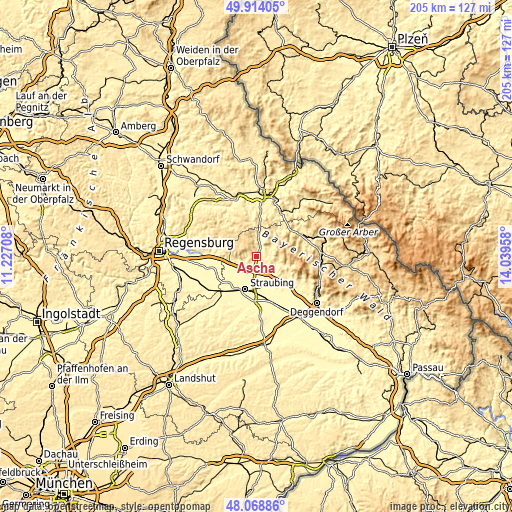
| \ | Map #1 | Topo.Map |
| Scale [m] | 328..668 m | × |
| Scale [ft] | 1076..2192 ft | × |
| Average | 411.6 m = 1350 ft | × |
| Width | 6.41 km = 4 mi | 205.2 km = 127.5 mi |
| Height | 6.41 km = 4 mi | 205.2 km = 127.5 mi |
| ↑Max Latitude | 49.028822° | 49.91405° |
| Latitude at center | 49° | 49° |
| ↓Min Latitude | 48.971161° | 48.06886° |
| ← Min Longitude | 12.589385° | 11.22708° |
| Longitude center | 12.63333° | 12.63333° |
| →Max Longitude | 12.677275° | 14.03958° |
Nearby cities:
Cities around Ascha sort by population:
• Bogen elevation 320 m
10.7 km,  157°
157°
• Kirchroth 321 m
8.2 km,  227°
227°
• Wiesenfelden 606 m
8.2 km,  303°
303°
• Hunderdorf 318 m
12.4 km,  166°
166°
• Parkstetten 320 m
9.6 km,  194°
194°
• Steinach 334 m
5.4 km,  200°
200°
• Mitterfels 426 m
4.2 km,  128°
128°
• Konzell 587 m
9.8 km,  35°
35°
• Neukirchen 373 m
9.3 km,  107°
107°
• Rattiszell 355 m
3.4 km,  33°
33°
• Windberg 430 m
10.4 km, 127°
• Falkenfels 484 m
2.8 km,  279°
279°
Multilingual:
 En español:
Ascha elevación 336 m.
 En France:
Ascha élévation 336 m.


Sources and notes:
- [note 1] Map square and city borders are not equal. Map elevation data is calculated only from area inside that square.
- [src 1] Elevation data from geonames database provided with same terms of usage.
- [src 2] The elevation map of Ascha is generated using elevation data from NASA's 3 arcsec (90m) resolution SRTM data.
- [src 3] Base (background) map © OpenStreetMap contributors tiles are generated by Geofabrik and OpenTopoMap.
Copyright & License:
This Ascha Elevation Map is licensed under CC BY-SA. You may reuse any part from this page, if you give a proper credit by linking to this URL:
 More info on terms of use page.