Aßling elevation
Aßling (Bavaria, Upper Bavaria), Germany elevation is 488 meters and Aßling elevation in feet is 1601 ft above sea level [src 1]. Aßling is a seat of a fourth-order administrative division (feature code) with elevation that is 230 meters (755 ft) bigger than average city elevation in Germany.
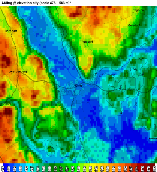
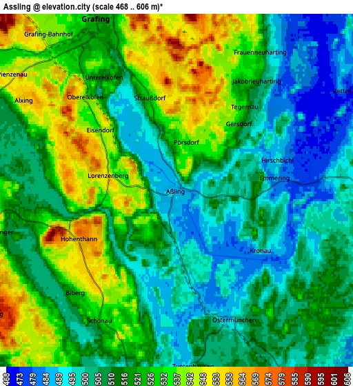
Below is the Elevation map of Aßling, which displays elevation range with different colors. Scale of the first map is from 476 to 583 m (1562 to 1913 ft) with average elevation of 513.2 meters (=1684 ft) [note 1]
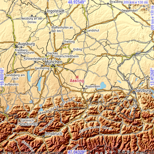
These maps also provides idea of topography and contour of this city, they are displayed at different zoom levels. More info about maps, scale and edge coordinates you can find below images.
| \ | Map #1 | Map #2 | Topo.Map |
| Scale [m] | 476..583 m | 468..606 m | × |
| Scale [ft] | 1562..1913 ft | 1535..1988 ft | × |
| Average | 513.2 m = 1684 ft | 516.3 m = 1694 ft | × |
| Width | 6.54 km = 4.1 mi | 13.08 km = 8.1 mi | 209.3 km = 130.1 mi |
| Height | 6.54 km = 4.1 mi | 13.08 km = 8.1 mi | 209.3 km = 130.1 mi |
| ↑Max Latitude | 48.022371° | 48.051755° | 48.92549° |
| Latitude at center | 47.99297° | 47.99297° | 47.99297° |
| ↓Min Latitude | 47.963552° | 47.934118° | 47.04329° |
| ← Min Longitude | 11.962485° | 11.918539° | 10.60018° |
| Longitude center | 12.00643° | 12.00643° | 12.00643° |
| →Max Longitude | 12.050375° | 12.094321° | 13.41268° |
Nearby cities:
Cities around Aßling sort by population:
• Grafing bei München elevation 519 m
6.5 km,  334°
334°
• Ebersberg 563 m
9.7 km,  344°
344°
• Tuntenhausen 503 m
6.5 km,  174°
174°
• Glonn 535 m
10.4 km,  266°
266°
• Pfaffing 487 m
10.3 km,  48°
48°
• Steinhöring 518 m
10.6 km,  10°
10°
• Rott 465 m
10.1 km,  143°
143°
• Eschenlohe 543 m
3.2 km,  33°
33°
• Emmering 484 m
3.8 km,  82°
82°
• Fraueneuharting 527 m
5.9 km, 31°
• Ramerberg 477 m
10.7 km,  74°
74°
• Bruck 510 m
8 km,  293°
293°
Multilingual:
 En español:
Aßling elevación 488 m.
 En France:
Aßling élévation 488 m.


Sources and notes:
- [note 1] Map square and city borders are not equal. Map elevation data is calculated only from area inside that square.
- [src 1] Elevation data from geonames database provided with same terms of usage.
- [src 2] The elevation map of Aßling is generated using elevation data from NASA's 3 arcsec (90m) resolution SRTM data.
- [src 3] Base (background) map © OpenStreetMap contributors tiles are generated by Geofabrik and OpenTopoMap.
Copyright & License:
This Aßling Elevation Map is licensed under CC BY-SA. You may reuse any part from this page, if you give a proper credit by linking to this URL:
 More info on terms of use page.