Aying elevation
Aying (Bavaria, Upper Bavaria), Germany elevation is 612 meters and Aying elevation in feet is 2008 ft above sea level [src 1]. Aying is a seat of a fourth-order administrative division (feature code) with elevation that is 354 meters (1161 ft) bigger than average city elevation in Germany.
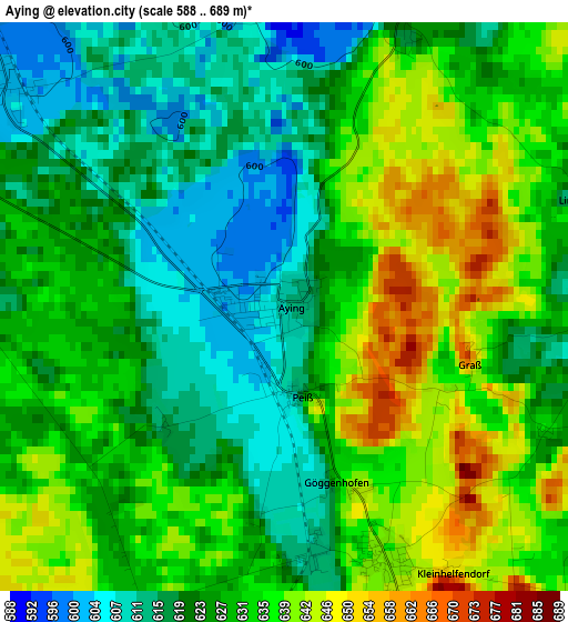
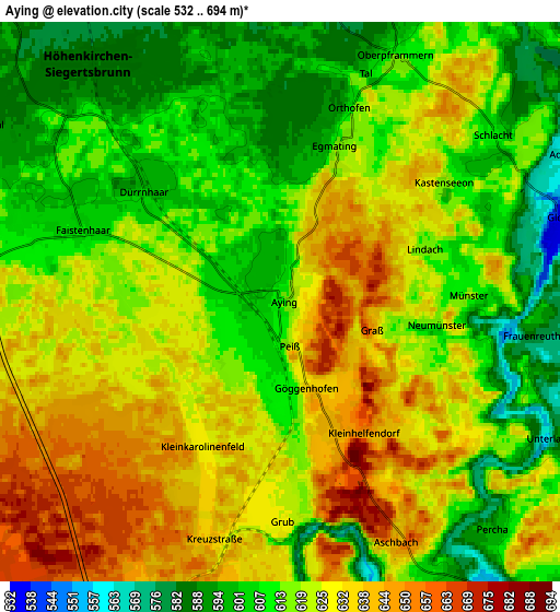
Below is the Elevation map of Aying, which displays elevation range with different colors. Scale of the first map is from 588 to 689 m (1929 to 2260 ft) with average elevation of 627.9 meters (=2060 ft) [note 1]
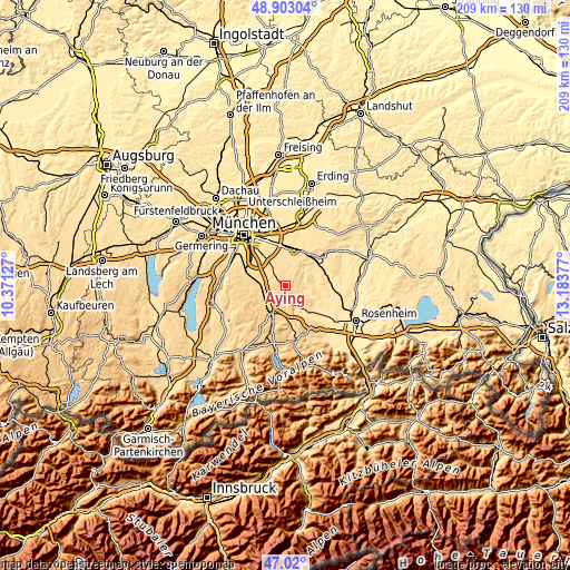
These maps also provides idea of topography and contour of this city, they are displayed at different zoom levels. More info about maps, scale and edge coordinates you can find below images.
| \ | Map #1 | Map #2 | Topo.Map |
| Scale [m] | 588..689 m | 532..694 m | × |
| Scale [ft] | 1929..2260 ft | 1745..2277 ft | × |
| Average | 627.9 m = 2060 ft | 619.7 m = 2033 ft | × |
| Width | 6.54 km = 4.1 mi | 13.09 km = 8.1 mi | 209.4 km = 130.1 mi |
| Height | 6.54 km = 4.1 mi | 13.09 km = 8.1 mi | 209.4 km = 130.1 mi |
| ↑Max Latitude | 47.999514° | 48.028911° | 48.90304° |
| Latitude at center | 47.9701° | 47.9701° | 47.9701° |
| ↓Min Latitude | 47.940669° | 47.911222° | 47.02° |
| ← Min Longitude | 11.733575° | 11.689629° | 10.37127° |
| Longitude center | 11.77752° | 11.77752° | 11.77752° |
| →Max Longitude | 11.821465° | 11.865411° | 13.18377° |
Nearby cities:
Cities around Aying sort by population:
• Feldkirchen-Westerham elevation 553 m
8.5 km,  145°
145°
• Höhenkirchen-Siegertsbrunn 587 m
7 km,  321°
321°
• Hohenbrunn 571 m
10.3 km,  327°
327°
• Sauerlach 619 m
9.2 km,  271°
271°
• Brunnthal 593 m
8 km,  300°
300°
• Otterfing 677 m
10.2 km,  228°
228°
• Glonn 535 m
7 km,  73°
73°
• Valley 650 m
8.6 km,  179°
179°
• Oberpframmern 615 m
6.4 km,  24°
24°
• Egmating 612 m
4 km, 19°
• Moosach 530 m
10 km,  46°
46°
• Bruck 510 m
11.2 km,  59°
59°
Multilingual:
 En español:
Aying elevación 612 m.
 En France:
Aying élévation 612 m.


Sources and notes:
- [note 1] Map square and city borders are not equal. Map elevation data is calculated only from area inside that square.
- [src 1] Elevation data from geonames database provided with same terms of usage.
- [src 2] The elevation map of Aying is generated using elevation data from NASA's 3 arcsec (90m) resolution SRTM data.
- [src 3] Base (background) map © OpenStreetMap contributors tiles are generated by Geofabrik and OpenTopoMap.
Copyright & License:
This Aying Elevation Map is licensed under CC BY-SA. You may reuse any part from this page, if you give a proper credit by linking to this URL:
 More info on terms of use page.