Otterfing elevation
Otterfing (Bavaria, Upper Bavaria), Germany elevation is 677 meters and Otterfing elevation in feet is 2221 ft above sea level [src 1]. Otterfing is a seat of a fourth-order administrative division (feature code) with elevation that is 419 meters (1375 ft) bigger than average city elevation in Germany.
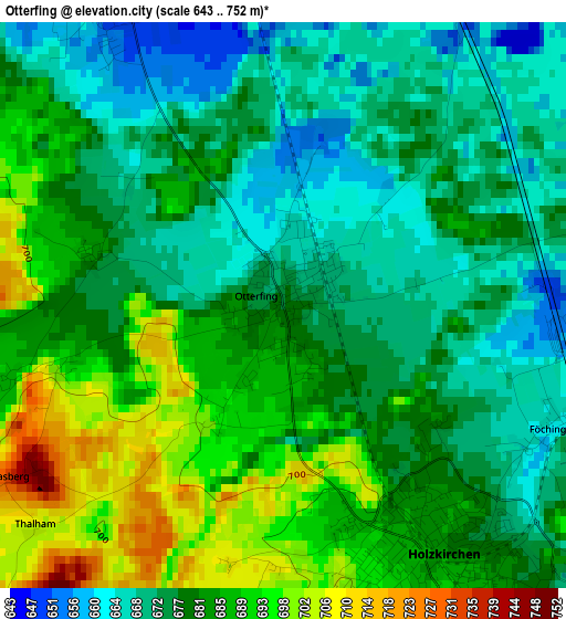
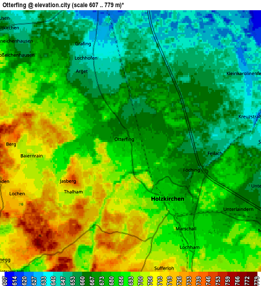
Below is the Elevation map of Otterfing, which displays elevation range with different colors. Scale of the first map is from 643 to 752 m (2110 to 2467 ft) with average elevation of 679.8 meters (=2230 ft) [note 1]
These maps also provides idea of topography and contour of this city, they are displayed at different zoom levels. More info about maps, scale and edge coordinates you can find below images.
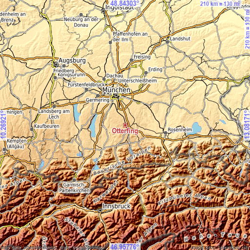
| \ | Map #1 | Map #2 | Topo.Map |
| Scale [m] | 643..752 m | 607..779 m | × |
| Scale [ft] | 2110..2467 ft | 1991..2556 ft | × |
| Average | 679.8 m = 2230 ft | 680.4 m = 2232 ft | × |
| Width | 6.55 km = 4.1 mi | 13.1 km = 8.1 mi | 209.6 km = 130.2 mi |
| Height | 6.55 km = 4.1 mi | 13.1 km = 8.1 mi | 209.6 km = 130.2 mi |
| ↑Max Latitude | 47.938429° | 47.96786° | 48.84303° |
| Latitude at center | 47.90898° | 47.90898° | 47.90898° |
| ↓Min Latitude | 47.879515° | 47.850032° | 46.95776° |
| ← Min Longitude | 11.631515° | 11.587569° | 10.26921° |
| Longitude center | 11.67546° | 11.67546° | 11.67546° |
| →Max Longitude | 11.719405° | 11.763351° | 13.08171° |
Nearby cities:
Cities around Otterfing sort by population:
• Holzkirchen elevation 691 m
4.1 km,  151°
151°
• Feldkirchen-Westerham 553 m
12.5 km,  90°
90°
• Höhenkirchen-Siegertsbrunn 587 m
12.7 km,  14°
14°
• Sauerlach 619 m
7.2 km,  346°
346°
• Dietramszell 688 m
9 km,  221°
221°
• Reichertshausen 698 m
8.8 km,  262°
262°
• Brunnthal 593 m
10.9 km,  3°
3°
• Aying 612 m
10.2 km,  48°
48°
• Warngau 721 m
9.2 km,  157°
157°
• Weyarn 673 m
10.8 km,  121°
121°
• Valley 650 m
7.9 km,  102°
102°
• Sachsenkam 720 m
11.8 km,  191°
191°
Multilingual:
 En español:
Otterfing elevación 677 m.
 En France:
Otterfing élévation 677 m.
 Auf Deutsch:
Otterfing höhe über dem Meeresspiegel ist 677 m.

Sources and notes:
- [note 1] Map square and city borders are not equal. Map elevation data is calculated only from area inside that square.
- [src 1] Elevation data from geonames database provided with same terms of usage.
- [src 2] The elevation map of Otterfing is generated using elevation data from NASA's 3 arcsec (90m) resolution SRTM data.
- [src 3] Base (background) map © OpenStreetMap contributors tiles are generated by Geofabrik and OpenTopoMap.
Copyright & License:
This Otterfing Elevation Map is licensed under CC BY-SA. You may reuse any part from this page, if you give a proper credit by linking to this URL:
 More info on terms of use page.