Bad Liebenstein elevation
Bad Liebenstein (Thuringia), Germany elevation is 326 meters and Bad Liebenstein elevation in feet is 1070 ft above sea level [src 1]. Bad Liebenstein is a populated place (feature code) with elevation that is 68 meters (223 ft) bigger than average city elevation in Germany.
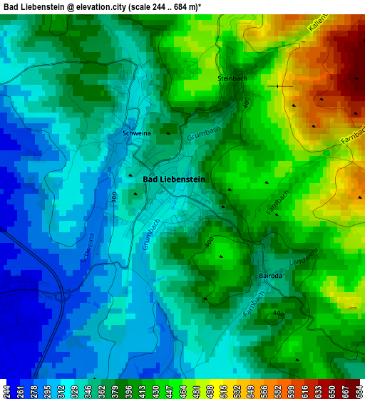
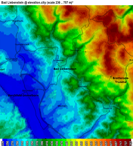
Below is the Elevation map of Bad Liebenstein, which displays elevation range with different colors. Scale of the first map is from 244 to 684 m (801 to 2244 ft) with average elevation of 380.1 meters (=1247 ft) [note 1]
These maps also provides idea of topography and contour of this city, they are displayed at different zoom levels. More info about maps, scale and edge coordinates you can find below images.
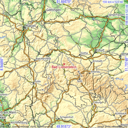
| \ | Map #1 | Map #2 | Topo.Map |
| Scale [m] | 244..684 m | 236..757 m | × |
| Scale [ft] | 801..2244 ft | 774..2484 ft | × |
| Average | 380.1 m = 1247 ft | 414.5 m = 1360 ft | × |
| Width | 6.17 km = 3.8 mi | 12.35 km = 7.7 mi | 197.6 km = 122.8 mi |
| Height | 6.17 km = 3.8 mi | 12.35 km = 7.7 mi | 197.6 km = 122.8 mi |
| ↑Max Latitude | 50.843447° | 50.871188° | 51.69575° |
| Latitude at center | 50.81569° | 50.81569° | 50.81569° |
| ↓Min Latitude | 50.787916° | 50.760126° | 49.91873° |
| ← Min Longitude | 10.307285° | 10.263339° | 8.94498° |
| Longitude center | 10.35123° | 10.35123° | 10.35123° |
| →Max Longitude | 10.395175° | 10.439121° | 11.75748° |
Nearby cities:
Cities around Bad Liebenstein sort by population:
• Bad Salzungen elevation 250 m
8.1 km,  268°
268°
• Ruhla 418 m
8.7 km,  6°
6°
• Breitungen 252 m
6 km,  196°
196°
• Trusetal 406 m
5.8 km,  128°
128°
• Wernshausen 263 m
10.2 km,  180°
180°
• Schweina 306 m
1.4 km,  317°
317°
• Brotterode 564 m
6.6 km,  81°
81°
• Fambach 266 m
9.2 km,  173°
173°
• Leimbach 238 m
10.6 km, 270°
• Immelborn 252 m
5.8 km,  243°
243°
• Pappenheim 457 m
9 km,  103°
103°
• Steinbach 394 m
2.1 km,  24°
24°
Multilingual:
 En español:
Bad Liebenstein elevación 326 m.
 En France:
Bad Liebenstein élévation 326 m.
 Auf Deutsch:
Bad Liebenstein höhe über dem Meeresspiegel ist 326 m.

Sources and notes:
- [note 1] Map square and city borders are not equal. Map elevation data is calculated only from area inside that square.
- [src 1] Elevation data from geonames database provided with same terms of usage.
- [src 2] The elevation map of Bad Liebenstein is generated using elevation data from NASA's 3 arcsec (90m) resolution SRTM data.
- [src 3] Base (background) map © OpenStreetMap contributors tiles are generated by Geofabrik and OpenTopoMap.
Copyright & License:
This Bad Liebenstein Elevation Map is licensed under CC BY-SA. You may reuse any part from this page, if you give a proper credit by linking to this URL:
 More info on terms of use page.