Bad Salzdetfurth elevation
Bad Salzdetfurth (Lower Saxony), Germany elevation is 110 meters and Bad Salzdetfurth elevation in feet is 361 ft above sea level [src 1]. Bad Salzdetfurth is a populated place (feature code) with elevation that is 148 meters (486 ft) smaller than average city elevation in Germany.
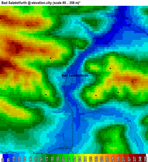
Below is the Elevation map of Bad Salzdetfurth, which displays elevation range with different colors. Scale of the first map is from 89 to 358 m (292 to 1175 ft) with average elevation of 181.2 meters (=594 ft) [note 1]
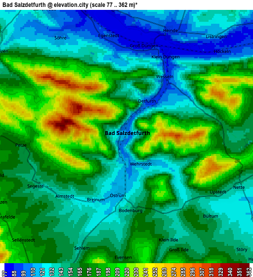
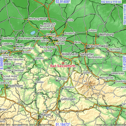
These maps also provides idea of topography and contour of this city, they are displayed at different zoom levels. More info about maps, scale and edge coordinates you can find below images.
| \ | Map #1 | Map #2 | Topo.Map |
| Scale [m] | 89..358 m | 77..362 m | × |
| Scale [ft] | 292..1175 ft | 253..1188 ft | × |
| Average | 181.2 m = 594 ft | 165.4 m = 543 ft | × |
| Width | 6.01 km = 3.7 mi | 12.02 km = 7.5 mi | 192.3 km = 119.5 mi |
| Height | 6.01 km = 3.7 mi | 12.02 km = 7.5 mi | 192.3 km = 119.5 mi |
| ↑Max Latitude | 52.084782° | 52.111778° | 52.91408° |
| Latitude at center | 52.05777° | 52.05777° | 52.05777° |
| ↓Min Latitude | 52.030741° | 52.003696° | 51.18473° |
| ← Min Longitude | 9.961855° | 9.917909° | 8.59955° |
| Longitude center | 10.0058° | 10.0058° | 10.0058° |
| →Max Longitude | 10.049745° | 10.093691° | 11.41205° |
Nearby cities:
Cities around Bad Salzdetfurth sort by population:
• Hildesheim elevation 92 m
11 km,  340°
340°
• Alfeld 91 m
15.1 km,  237°
237°
• Bockenem 122 m
10.1 km,  121°
121°
• Schellerten 91 m
15.6 km,  24°
24°
• Holle 111 m
11 km,  72°
72°
• Diekholzen 122 m
7.3 km,  305°
305°
• Lamspringe 214 m
10.8 km,  178°
178°
• Sibbesse 191 m
7.3 km,  263°
263°
• Haverlah 129 m
11 km,  84°
84°
• Rheden 90 m
14.9 km,  270°
270°
• Sehlem 145 m
5.4 km,  202°
202°
• Adenstedt 205 m
8.2 km,  216°
216°
Multilingual:
 En español:
Bad Salzdetfurth elevación 110 m.
 En France:
Bad Salzdetfurth élévation 110 m.
 Auf Deutsch:
Bad Salzdetfurth höhe über dem Meeresspiegel ist 110 m.

Sources and notes:
- [note 1] Map square and city borders are not equal. Map elevation data is calculated only from area inside that square.
- [src 1] Elevation data from geonames database provided with same terms of usage.
- [src 2] The elevation map of Bad Salzdetfurth is generated using elevation data from NASA's 3 arcsec (90m) resolution SRTM data.
- [src 3] Base (background) map © OpenStreetMap contributors tiles are generated by Geofabrik and OpenTopoMap.
Copyright & License:
This Bad Salzdetfurth Elevation Map is licensed under CC BY-SA. You may reuse any part from this page, if you give a proper credit by linking to this URL:
 More info on terms of use page.