Bad Sooden-Allendorf elevation
Bad Sooden-Allendorf (Hesse, Regierungsbezirk Kassel), Germany elevation is 158 meters and Bad Sooden-Allendorf elevation in feet is 518 ft above sea level [src 1]. Bad Sooden-Allendorf is a populated place (feature code) with elevation that is 100 meters (328 ft) smaller than average city elevation in Germany.
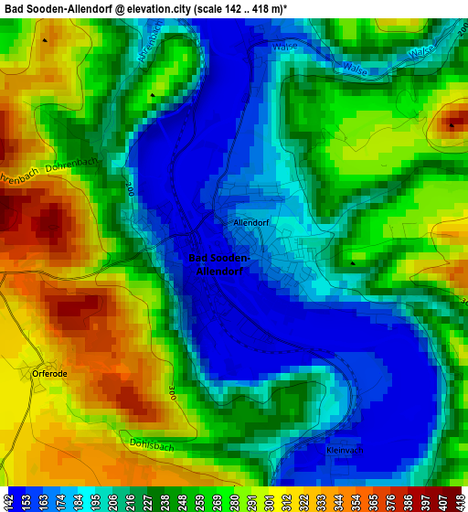
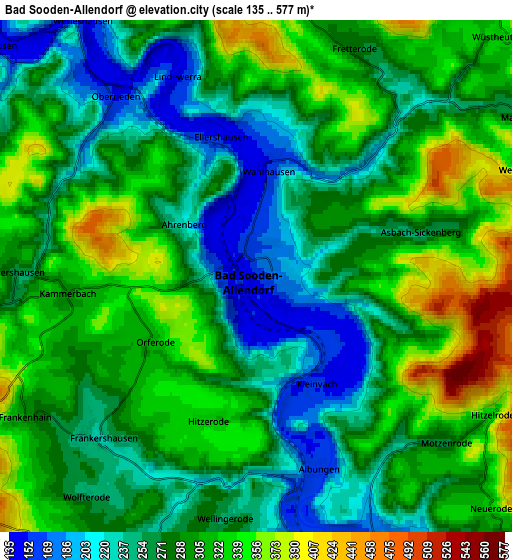
Below is the Elevation map of Bad Sooden-Allendorf, which displays elevation range with different colors. Scale of the first map is from 142 to 418 m (466 to 1371 ft) with average elevation of 240.7 meters (=790 ft) [note 1]
These maps also provides idea of topography and contour of this city, they are displayed at different zoom levels. More info about maps, scale and edge coordinates you can find below images.
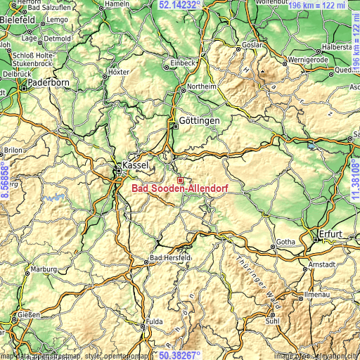
| \ | Map #1 | Map #2 | Topo.Map |
| Scale [m] | 142..418 m | 135..577 m | × |
| Scale [ft] | 466..1371 ft | 443..1893 ft | × |
| Average | 240.7 m = 790 ft | 286.6 m = 940 ft | × |
| Width | 6.11 km = 3.8 mi | 12.23 km = 7.6 mi | 195.7 km = 121.6 mi |
| Height | 6.11 km = 3.8 mi | 12.23 km = 7.6 mi | 195.6 km = 121.5 mi |
| ↑Max Latitude | 51.298406° | 51.325875° | 52.14232° |
| Latitude at center | 51.27092° | 51.27092° | 51.27092° |
| ↓Min Latitude | 51.243418° | 51.215899° | 50.38267° |
| ← Min Longitude | 9.930885° | 9.886939° | 8.56858° |
| Longitude center | 9.97483° | 9.97483° | 9.97483° |
| →Max Longitude | 10.018775° | 10.062721° | 11.38108° |
Nearby cities:
Cities around Bad Sooden-Allendorf sort by population:
• Eschwege elevation 175 m
11.1 km,  150°
150°
• Heilbad Heiligenstadt 264 m
16.4 km,  43°
43°
• Witzenhausen 151 m
11.4 km,  313°
313°
• Friedland 181 m
17 km,  346°
346°
• Gemeinde Friedland 255 m
16.5 km, 349°
• Großalmerode 374 m
13.3 km,  264°
264°
• Waldkappel 237 m
15.6 km,  205°
205°
• Wanfried 177 m
17 km,  125°
125°
• Uder 234 m
12.2 km,  33°
33°
• Geismar 212 m
14 km,  108°
108°
• Großbartloff 281 m
17 km,  97°
97°
• Arenshausen 204 m
11.7 km,  357°
357°
Multilingual:
 En español:
Bad Sooden-Allendorf elevación 158 m.
 En France:
Bad Sooden-Allendorf élévation 158 m.
 Auf Deutsch:
Bad Sooden-Allendorf höhe über dem Meeresspiegel ist 158 m.
 На русском:
Бад-Зоден-Аллендорф высота над уровнем моря 158 м
Sources and notes:
- [note 1] Map square and city borders are not equal. Map elevation data is calculated only from area inside that square.
- [src 1] Elevation data from geonames database provided with same terms of usage.
- [src 2] The elevation map of Bad Sooden-Allendorf is generated using elevation data from NASA's 3 arcsec (90m) resolution SRTM data.
- [src 3] Base (background) map © OpenStreetMap contributors tiles are generated by Geofabrik and OpenTopoMap.
Copyright & License:
This Bad Sooden-Allendorf Elevation Map is licensed under CC BY-SA. You may reuse any part from this page, if you give a proper credit by linking to this URL:
 More info on terms of use page.