Baunach elevation
Baunach (Bavaria, Upper Franconia), Germany elevation is 247 meters and Baunach elevation in feet is 810 ft above sea level [src 1]. Baunach is a populated place (feature code) with elevation that is 11 meters (36 ft) smaller than average city elevation in Germany.
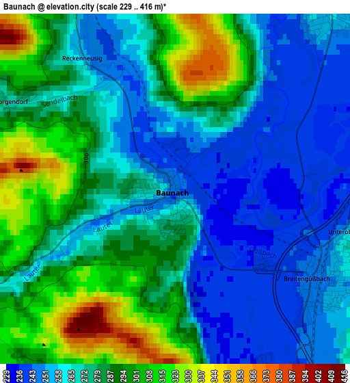
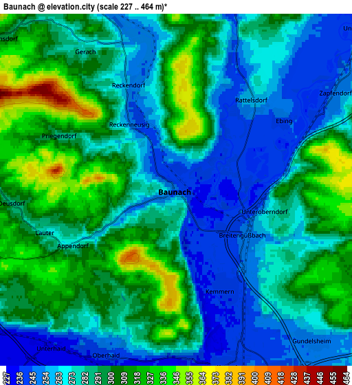
Below is the Elevation map of Baunach, which displays elevation range with different colors. Scale of the first map is from 229 to 416 m (751 to 1365 ft) with average elevation of 276.8 meters (=908 ft) [note 1]
These maps also provides idea of topography and contour of this city, they are displayed at different zoom levels. More info about maps, scale and edge coordinates you can find below images.
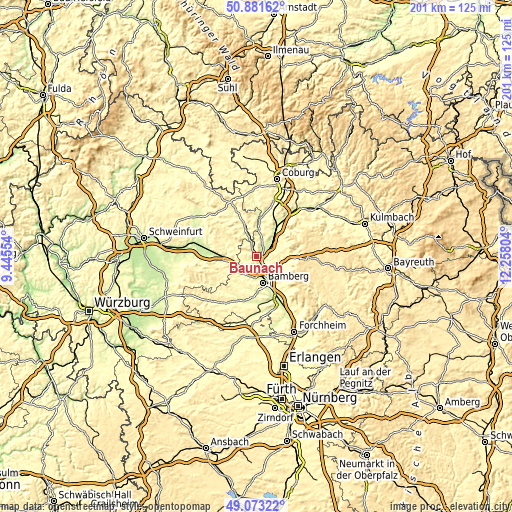
| \ | Map #1 | Map #2 | Topo.Map |
| Scale [m] | 229..416 m | 227..464 m | × |
| Scale [ft] | 751..1365 ft | 745..1522 ft | × |
| Average | 276.8 m = 908 ft | 286.5 m = 940 ft | × |
| Width | 6.28 km = 3.9 mi | 12.57 km = 7.8 mi | 201.1 km = 125 mi |
| Height | 6.28 km = 3.9 mi | 12.57 km = 7.8 mi | 201.1 km = 125 mi |
| ↑Max Latitude | 50.014167° | 50.042398° | 50.88162° |
| Latitude at center | 49.98592° | 49.98592° | 49.98592° |
| ↓Min Latitude | 49.957656° | 49.929375° | 49.07322° |
| ← Min Longitude | 10.807845° | 10.763899° | 9.44554° |
| Longitude center | 10.85179° | 10.85179° | 10.85179° |
| →Max Longitude | 10.895735° | 10.939681° | 12.25804° |
Nearby cities:
Cities around Baunach sort by population:
• Hallstadt elevation 242 m
6.5 km,  165°
165°
• Bischberg 241 m
8.5 km,  189°
189°
• Zapfendorf 249 m
6.8 km,  58°
58°
• Breitengüßbach 247 m
2.9 km,  122°
122°
• Rattelsdorf 259 m
4.2 km,  39°
39°
• Viereth-Trunstadt 240 m
8.9 km,  217°
217°
• Gundelsheim 250 m
7.3 km,  138°
138°
• Kemmern 239 m
3.9 km,  151°
151°
• Rentweinsdorf 265 m
9.4 km,  336°
336°
• Stettfeld 247 m
9.5 km,  259°
259°
• Lauter 277 m
4.7 km,  252°
252°
• Gerach 283 m
6.4 km,  324°
324°
Multilingual:
 En español:
Baunach elevación 247 m.
 En France:
Baunach élévation 247 m.


Sources and notes:
- [note 1] Map square and city borders are not equal. Map elevation data is calculated only from area inside that square.
- [src 1] Elevation data from geonames database provided with same terms of usage.
- [src 2] The elevation map of Baunach is generated using elevation data from NASA's 3 arcsec (90m) resolution SRTM data.
- [src 3] Base (background) map © OpenStreetMap contributors tiles are generated by Geofabrik and OpenTopoMap.
Copyright & License:
This Baunach Elevation Map is licensed under CC BY-SA. You may reuse any part from this page, if you give a proper credit by linking to this URL:
 More info on terms of use page.