Rattelsdorf elevation
Rattelsdorf (Bavaria, Upper Franconia), Germany elevation is 259 meters and Rattelsdorf elevation in feet is 850 ft above sea level [src 1]. Rattelsdorf is a populated place (feature code) with elevation that is 1 meters (3 ft) bigger than average city elevation in Germany.
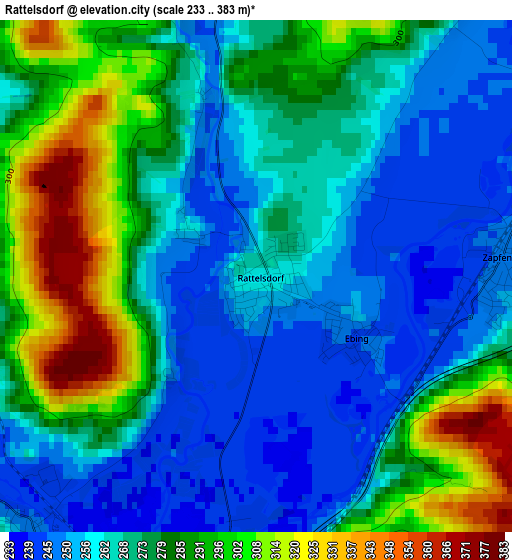
Below is the Elevation map of Rattelsdorf, which displays elevation range with different colors. Scale of the first map is from 233 to 383 m (764 to 1257 ft) with average elevation of 273.4 meters (=897 ft) [note 1]
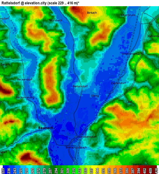
These maps also provides idea of topography and contour of this city, they are displayed at different zoom levels. More info about maps, scale and edge coordinates you can find below images.
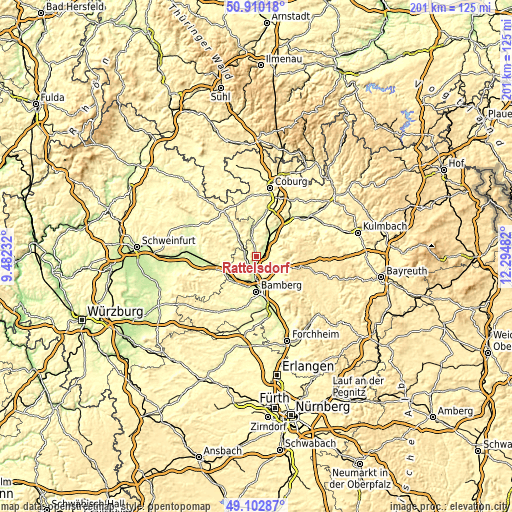
| \ | Map #1 | Map #2 | Topo.Map |
| Scale [m] | 233..383 m | 229..416 m | × |
| Scale [ft] | 764..1257 ft | 751..1365 ft | × |
| Average | 273.4 m = 897 ft | 289.4 m = 949 ft | × |
| Width | 6.28 km = 3.9 mi | 12.56 km = 7.8 mi | 201 km = 124.9 mi |
| Height | 6.28 km = 3.9 mi | 12.56 km = 7.8 mi | 200.9 km = 124.8 mi |
| ↑Max Latitude | 50.04325° | 50.071464° | 50.91018° |
| Latitude at center | 50.01502° | 50.01502° | 50.01502° |
| ↓Min Latitude | 49.986773° | 49.958509° | 49.10287° |
| ← Min Longitude | 10.844625° | 10.800679° | 9.48232° |
| Longitude center | 10.88857° | 10.88857° | 10.88857° |
| →Max Longitude | 10.932515° | 10.976461° | 12.29482° |
Nearby cities:
Cities around Rattelsdorf sort by population:
• Memmelsdorf elevation 285 m
10.7 km,  151°
151°
• Hallstadt 242 m
9.6 km,  185°
185°
• Scheßlitz 307 m
11.2 km,  112°
112°
• Ebensfeld 259 m
7.6 km,  41°
41°
• Zapfendorf 249 m
3.1 km,  84°
84°
• Breitengüßbach 247 m
4.8 km,  182°
182°
• Baunach 247 m
4.2 km,  219°
219°
• Gundelsheim 250 m
9 km,  165°
165°
• Kemmern 239 m
6.7 km, 186°
• Rentweinsdorf 265 m
8.3 km,  310°
310°
• Lauter 277 m
8.5 km,  236°
236°
• Gerach 283 m
6.6 km,  287°
287°
Multilingual:
 En español:
Rattelsdorf elevación 259 m.
 En France:
Rattelsdorf élévation 259 m.
 Auf Deutsch:
Rattelsdorf höhe über dem Meeresspiegel ist 259 m.

Sources and notes:
- [note 1] Map square and city borders are not equal. Map elevation data is calculated only from area inside that square.
- [src 1] Elevation data from geonames database provided with same terms of usage.
- [src 2] The elevation map of Rattelsdorf is generated using elevation data from NASA's 3 arcsec (90m) resolution SRTM data.
- [src 3] Base (background) map © OpenStreetMap contributors tiles are generated by Geofabrik and OpenTopoMap.
Copyright & License:
This Rattelsdorf Elevation Map is licensed under CC BY-SA. You may reuse any part from this page, if you give a proper credit by linking to this URL:
 More info on terms of use page.