Bempflingen elevation
Bempflingen (Baden-Württemberg, Regierungsbezirk Stuttgart), Germany elevation is 316 meters and Bempflingen elevation in feet is 1037 ft above sea level [src 1]. Bempflingen is a seat of a fourth-order administrative division (feature code) with elevation that is 58 meters (190 ft) bigger than average city elevation in Germany.
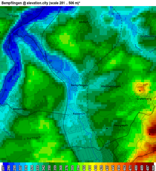
Below is the Elevation map of Bempflingen, which displays elevation range with different colors. Scale of the first map is from 281 to 506 m (922 to 1660 ft) with average elevation of 351.5 meters (=1153 ft) [note 1]
These maps also provides idea of topography and contour of this city, they are displayed at different zoom levels. More info about maps, scale and edge coordinates you can find below images.
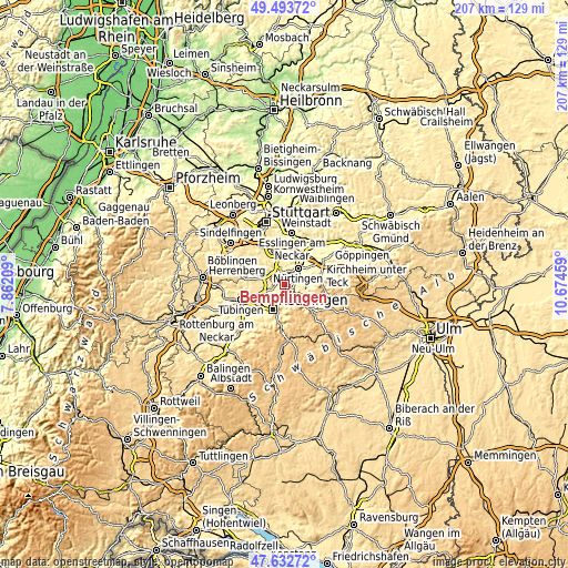
| \ | Map #1 | Topo.Map |
| Scale [m] | 281..506 m | × |
| Scale [ft] | 922..1660 ft | × |
| Average | 351.5 m = 1153 ft | × |
| Width | 6.47 km = 4 mi | 206.9 km = 128.6 mi |
| Height | 6.47 km = 4 mi | 206.9 km = 128.6 mi |
| ↑Max Latitude | 48.600849° | 49.49372° |
| Latitude at center | 48.57178° | 48.57178° |
| ↓Min Latitude | 48.542694° | 47.63272° |
| ← Min Longitude | 9.224395° | 7.86209° |
| Longitude center | 9.26834° | 9.26834° |
| →Max Longitude | 9.312285° | 10.67459° |
Nearby cities:
Cities around Bempflingen sort by population:
• Metzingen elevation 350 m
4 km,  164°
164°
• Pliezhausen 341 m
4.7 km,  252°
252°
• Dettingen an der Erms 396 m
7.2 km,  129°
129°
• Frickenhausen 322 m
7.2 km,  70°
70°
• Neckartenzlingen 294 m
3.2 km,  309°
309°
• Riederich 324 m
1.3 km,  178°
178°
• Großbettlingen 344 m
3.6 km,  54°
54°
• Neckartailfingen 285 m
4.5 km,  355°
355°
• Kohlberg 468 m
5.2 km,  106°
106°
• Altenriet 407 m
4.1 km,  302°
302°
• Schlaitdorf 398 m
4.9 km,  317°
317°
• Altdorf 355 m
2.5 km,  5°
5°
Multilingual:
 En español:
Bempflingen elevación 316 m.
 En France:
Bempflingen élévation 316 m.
 Auf Deutsch:
Bempflingen höhe über dem Meeresspiegel ist 316 m.

Sources and notes:
- [note 1] Map square and city borders are not equal. Map elevation data is calculated only from area inside that square.
- [src 1] Elevation data from geonames database provided with same terms of usage.
- [src 2] The elevation map of Bempflingen is generated using elevation data from NASA's 3 arcsec (90m) resolution SRTM data.
- [src 3] Base (background) map © OpenStreetMap contributors tiles are generated by Geofabrik and OpenTopoMap.
Copyright & License:
This Bempflingen Elevation Map is licensed under CC BY-SA. You may reuse any part from this page, if you give a proper credit by linking to this URL:
 More info on terms of use page.