Schlaitdorf elevation
Schlaitdorf (Baden-Württemberg, Regierungsbezirk Stuttgart), Germany elevation is 398 meters and Schlaitdorf elevation in feet is 1306 ft above sea level [src 1]. Schlaitdorf is a seat of a fourth-order administrative division (feature code) with elevation that is 140 meters (459 ft) bigger than average city elevation in Germany.
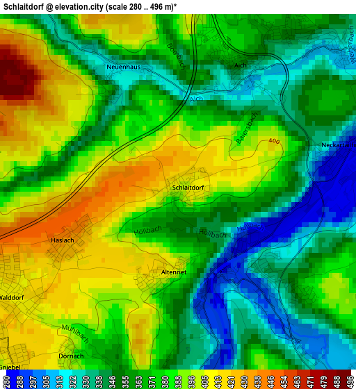
Below is the Elevation map of Schlaitdorf, which displays elevation range with different colors. Scale of the first map is from 280 to 496 m (919 to 1627 ft) with average elevation of 371.9 meters (=1220 ft) [note 1]
These maps also provides idea of topography and contour of this city, they are displayed at different zoom levels. More info about maps, scale and edge coordinates you can find below images.

| \ | Map #1 | Topo.Map |
| Scale [m] | 280..496 m | × |
| Scale [ft] | 919..1627 ft | × |
| Average | 371.9 m = 1220 ft | × |
| Width | 6.46 km = 4 mi | 206.8 km = 128.5 mi |
| Height | 6.46 km = 4 mi | 206.8 km = 128.5 mi |
| ↑Max Latitude | 48.633361° | 49.52565° |
| Latitude at center | 48.60431° | 48.60431° |
| ↓Min Latitude | 48.575243° | 47.66585° |
| ← Min Longitude | 9.178735° | 7.81643° |
| Longitude center | 9.22268° | 9.22268° |
| →Max Longitude | 9.266625° | 10.62893° |
Nearby cities:
Cities around Schlaitdorf sort by population:
• Filderstadt elevation 393 m
5.9 km,  358°
358°
• Pliezhausen 341 m
5.1 km,  192°
192°
• Waldenbuch 347 m
7.6 km,  299°
299°
• Neckartenzlingen 294 m
1.8 km,  151°
151°
• Wolfschlugen 373 m
6.8 km,  41°
41°
• Riederich 324 m
6 km, 145°
• Großbettlingen 344 m
6.4 km,  103°
103°
• Neckartailfingen 285 m
3.1 km,  74°
74°
• Bempflingen 316 m
4.9 km,  137°
137°
• Sickenhausen 390 m
8.5 km,  200°
200°
• Altenriet 407 m
1.4 km,  182°
182°
• Altdorf 355 m
3.8 km,  107°
107°
Multilingual:
 En español:
Schlaitdorf elevación 398 m.
 En France:
Schlaitdorf élévation 398 m.
 Auf Deutsch:
Schlaitdorf höhe über dem Meeresspiegel ist 398 m.

Sources and notes:
- [note 1] Map square and city borders are not equal. Map elevation data is calculated only from area inside that square.
- [src 1] Elevation data from geonames database provided with same terms of usage.
- [src 2] The elevation map of Schlaitdorf is generated using elevation data from NASA's 3 arcsec (90m) resolution SRTM data.
- [src 3] Base (background) map © OpenStreetMap contributors tiles are generated by Geofabrik and OpenTopoMap.
Copyright & License:
This Schlaitdorf Elevation Map is licensed under CC BY-SA. You may reuse any part from this page, if you give a proper credit by linking to this URL:
 More info on terms of use page.