Bendestorf elevation
Bendestorf (Lower Saxony), Germany elevation is 72 meters and Bendestorf elevation in feet is 236 ft above sea level [src 1]. Bendestorf is a seat of a fourth-order administrative division (feature code) with elevation that is 186 meters (610 ft) smaller than average city elevation in Germany.
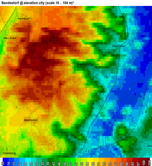
Below is the Elevation map of Bendestorf, which displays elevation range with different colors. Scale of the first map is from 10 to 104 m (33 to 341 ft) with average elevation of 55.5 meters (=182 ft) [note 1]
These maps also provides idea of topography and contour of this city, they are displayed at different zoom levels. More info about maps, scale and edge coordinates you can find below images.
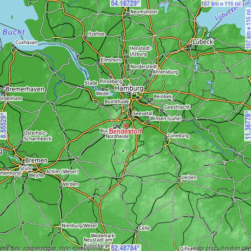
| \ | Map #1 | Topo.Map |
| Scale [m] | 10..104 m | × |
| Scale [ft] | 33..341 ft | × |
| Average | 55.5 m = 182 ft | × |
| Width | 5.84 km = 3.6 mi | 186.7 km = 116 mi |
| Height | 5.84 km = 3.6 mi | 186.7 km = 116 mi |
| ↑Max Latitude | 53.362063° | 54.16729° |
| Latitude at center | 53.33583° | 53.33583° |
| ↓Min Latitude | 53.309581° | 52.48784° |
| ← Min Longitude | 9.917595° | 8.55529° |
| Longitude center | 9.96154° | 9.96154° |
| →Max Longitude | 10.005485° | 11.36779° |
Nearby cities:
Cities around Bendestorf sort by population:
• Seevetal elevation 45 m
7.1 km,  2°
2°
• Buchholz in der Nordheide 75 m
6.3 km,  260°
260°
• Stelle 8 m
11.3 km,  61°
61°
• Jesteburg 50 m
3 km,  191°
191°
• Hanstedt 32 m
8.5 km,  154°
154°
• Handeloh 56 m
12.9 km,  219°
219°
• Toppenstedt 36 m
12.9 km,  128°
128°
• Asendorf 37 m
4.9 km,  166°
166°
• Brackel 45 m
7 km,  124°
124°
• Wulfsen 23 m
13.1 km,  107°
107°
• Wenzendorf 53 m
12.7 km,  276°
276°
• Marxen 28 m
3.9 km, 132°
Multilingual:
 En español:
Bendestorf elevación 72 m.
 En France:
Bendestorf élévation 72 m.
 Auf Deutsch:
Bendestorf höhe über dem Meeresspiegel ist 72 m.

Sources and notes:
- [note 1] Map square and city borders are not equal. Map elevation data is calculated only from area inside that square.
- [src 1] Elevation data from geonames database provided with same terms of usage.
- [src 2] The elevation map of Bendestorf is generated using elevation data from NASA's 3 arcsec (90m) resolution SRTM data.
- [src 3] Base (background) map © OpenStreetMap contributors tiles are generated by Geofabrik and OpenTopoMap.
Copyright & License:
This Bendestorf Elevation Map is licensed under CC BY-SA. You may reuse any part from this page, if you give a proper credit by linking to this URL:
 More info on terms of use page.