Berg elevation
Berg (Bavaria, Upper Palatinate), Germany elevation is 493 meters and Berg elevation in feet is 1617 ft above sea level [src 1]. Berg is a populated place (feature code) with elevation that is 235 meters (771 ft) bigger than average city elevation in Germany.
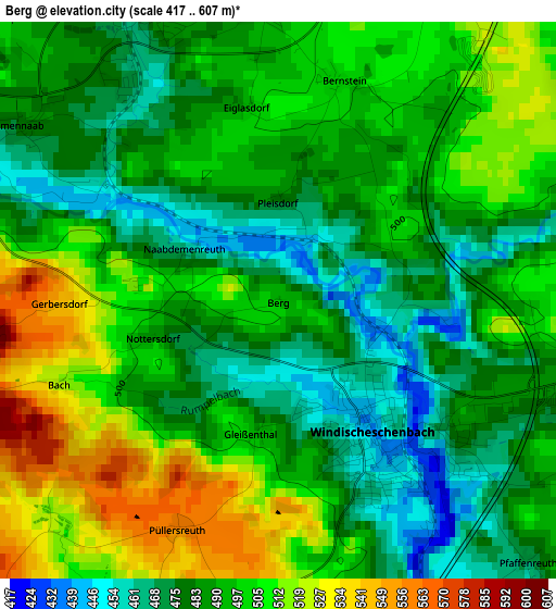
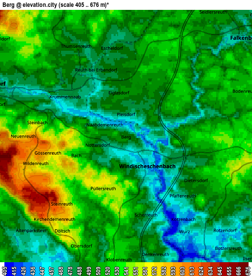
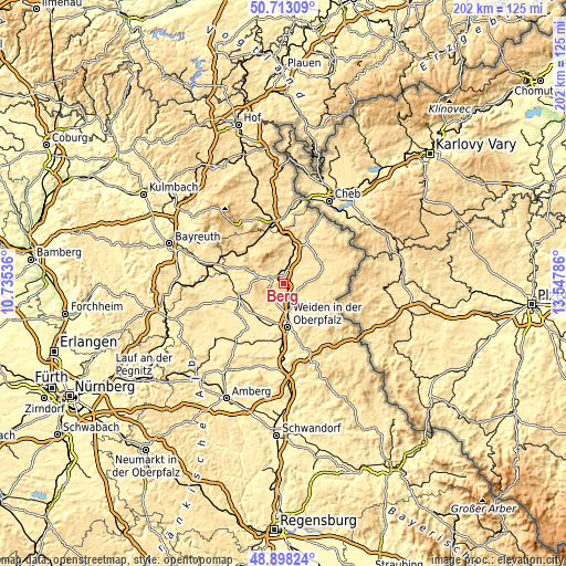
Below is the Elevation map of Berg, which displays elevation range with different colors. Scale of the first map is from 417 to 607 m (1368 to 1991 ft) with average elevation of 493.1 meters (=1618 ft) [note 1]
These maps also provides idea of topography and contour of this city, they are displayed at different zoom levels. More info about maps, scale and edge coordinates you can find below images.
| \ | Map #1 | Map #2 | Topo.Map |
| Scale [m] | 417..607 m | 405..676 m | × |
| Scale [ft] | 1368..1991 ft | 1329..2218 ft | × |
| Average | 493.1 m = 1618 ft | 507 m = 1663 ft | × |
| Width | 6.31 km = 3.9 mi | 12.61 km = 7.8 mi | 201.8 km = 125.4 mi |
| Height | 6.31 km = 3.9 mi | 12.61 km = 7.8 mi | 201.8 km = 125.4 mi |
| ↑Max Latitude | 49.842518° | 49.87085° | 50.71309° |
| Latitude at center | 49.81417° | 49.81417° | 49.81417° |
| ↓Min Latitude | 49.785805° | 49.757424° | 48.89824° |
| ← Min Longitude | 12.097665° | 12.053719° | 10.73536° |
| Longitude center | 12.14161° | 12.14161° | 12.14161° |
| →Max Longitude | 12.185555° | 12.229501° | 13.54786° |
Nearby cities:
Cities around Berg sort by population:
• Neustadt an der Waldnaab elevation 428 m
9.4 km,  163°
163°
• Windischeschenbach 450 m
1.8 km,  142°
142°
• Erbendorf 492 m
7.4 km,  292°
292°
• Wiesau 509 m
11 km,  17°
17°
• Floß 479 m
13.9 km, 136°
• Parkstein 511 m
10.8 km,  209°
209°
• Konradsreuth 520 m
13.7 km,  125°
125°
• Fuchsmühl 599 m
12.1 km,  1°
1°
• Krummennaab 484 m
3.7 km,  305°
305°
• Püchersreuth 494 m
9.7 km, 137°
• Störnstein 442 m
10.2 km,  153°
153°
• Friedenfels 523 m
8.1 km,  339°
339°
Multilingual:
 En español:
Berg elevación 493 m.
 En France:
Berg élévation 493 m.


Sources and notes:
- [note 1] Map square and city borders are not equal. Map elevation data is calculated only from area inside that square.
- [src 1] Elevation data from geonames database provided with same terms of usage.
- [src 2] The elevation map of Berg is generated using elevation data from NASA's 3 arcsec (90m) resolution SRTM data.
- [src 3] Base (background) map © OpenStreetMap contributors tiles are generated by Geofabrik and OpenTopoMap.
Copyright & License:
This Berg Elevation Map is licensed under CC BY-SA. You may reuse any part from this page, if you give a proper credit by linking to this URL:
 More info on terms of use page.