Berghülen elevation
Berghülen (Baden-Württemberg, Tübingen Region), Germany elevation is 693 meters and Berghülen elevation in feet is 2274 ft above sea level [src 1]. Berghülen is a seat of a fourth-order administrative division (feature code) with elevation that is 435 meters (1427 ft) bigger than average city elevation in Germany.
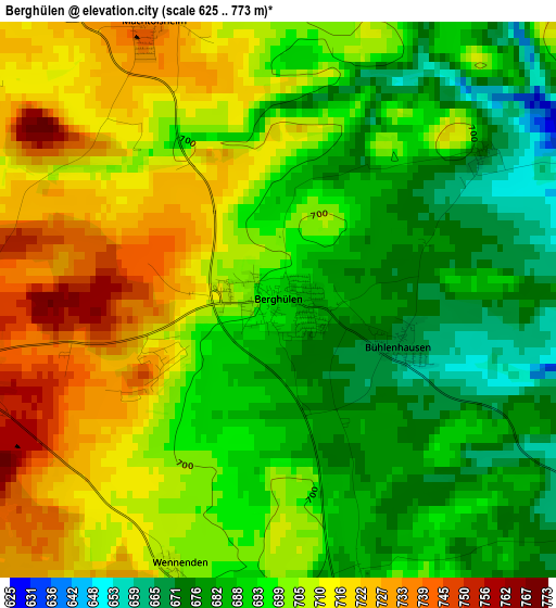
Below is the Elevation map of Berghülen, which displays elevation range with different colors. Scale of the first map is from 625 to 773 m (2051 to 2536 ft) with average elevation of 699 meters (=2293 ft) [note 1]
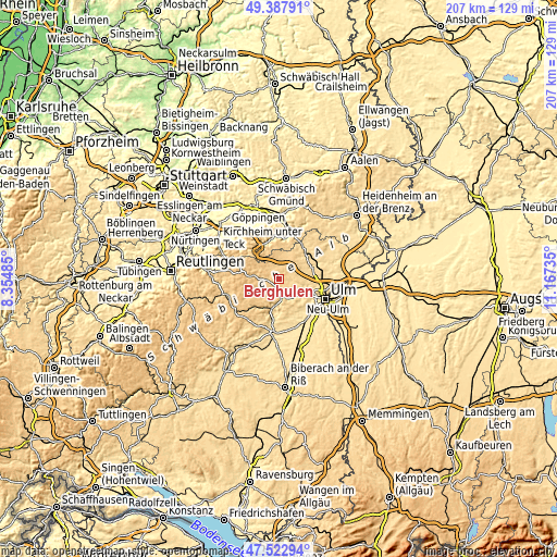
These maps also provides idea of topography and contour of this city, they are displayed at different zoom levels. More info about maps, scale and edge coordinates you can find below images.
| \ | Map #1 | Topo.Map |
| Scale [m] | 625..773 m | × |
| Scale [ft] | 2051..2536 ft | × |
| Average | 699 m = 2293 ft | × |
| Width | 6.48 km = 4 mi | 207.4 km = 128.9 mi |
| Height | 6.48 km = 4 mi | 207.4 km = 128.9 mi |
| ↑Max Latitude | 48.493121° | 49.38791° |
| Latitude at center | 48.46399° | 48.46399° |
| ↓Min Latitude | 48.434842° | 47.52294° |
| ← Min Longitude | 9.717155° | 8.35485° |
| Longitude center | 9.7611° | 9.7611° |
| →Max Longitude | 9.805045° | 11.16735° |
Nearby cities:
Cities around Berghülen sort by population:
• Klingenstein elevation 498 m
12 km,  115°
115°
• Blaubeuren 520 m
6 km,  163°
163°
• Laichingen 757 m
6.2 km,  297°
297°
• Dornstadt 594 m
13.5 km,  88°
88°
• Schelklingen 538 m
10 km,  192°
192°
• Lonsee 575 m
14.7 km,  52°
52°
• Bad Ditzenbach 504 m
14.4 km,  343°
343°
• Westerheim 816 m
11.6 km, 299°
• Wiesensteig 590 m
14.7 km,  317°
317°
• Nellingen 691 m
8.9 km,  14°
14°
• Merklingen 709 m
5.3 km,  355°
355°
• Mühlhausen 542 m
14.7 km,  328°
328°
Multilingual:
 En español:
Berghülen elevación 693 m.
 En France:
Berghülen élévation 693 m.
 Auf Deutsch:
Berghülen höhe über dem Meeresspiegel ist 693 m.

Sources and notes:
- [note 1] Map square and city borders are not equal. Map elevation data is calculated only from area inside that square.
- [src 1] Elevation data from geonames database provided with same terms of usage.
- [src 2] The elevation map of Berghülen is generated using elevation data from NASA's 3 arcsec (90m) resolution SRTM data.
- [src 3] Base (background) map © OpenStreetMap contributors tiles are generated by Geofabrik and OpenTopoMap.
Copyright & License:
This Berghülen Elevation Map is licensed under CC BY-SA. You may reuse any part from this page, if you give a proper credit by linking to this URL:
 More info on terms of use page.