Biebelried elevation
Biebelried (Bavaria, Regierungsbezirk Unterfranken), Germany elevation is 276 meters and Biebelried elevation in feet is 906 ft above sea level [src 1]. Biebelried is a seat of a fourth-order administrative division (feature code) with elevation that is 18 meters (59 ft) bigger than average city elevation in Germany.
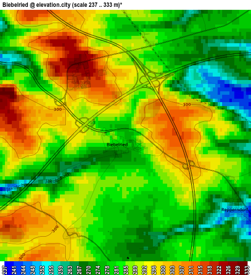
Below is the Elevation map of Biebelried, which displays elevation range with different colors. Scale of the first map is from 237 to 333 m (778 to 1093 ft) with average elevation of 286.1 meters (=939 ft) [note 1]
These maps also provides idea of topography and contour of this city, they are displayed at different zoom levels. More info about maps, scale and edge coordinates you can find below images.
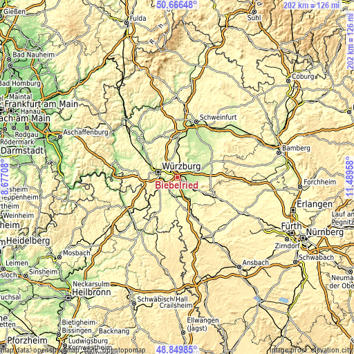
| \ | Map #1 | Topo.Map |
| Scale [m] | 237..333 m | × |
| Scale [ft] | 778..1093 ft | × |
| Average | 286.1 m = 939 ft | × |
| Width | 6.31 km = 3.9 mi | 202 km = 125.5 mi |
| Height | 6.31 km = 3.9 mi | 202 km = 125.5 mi |
| ↑Max Latitude | 49.795046° | 50.66648° |
| Latitude at center | 49.76667° | 49.76667° |
| ↓Min Latitude | 49.738277° | 48.84985° |
| ← Min Longitude | 10.039385° | 8.67708° |
| Longitude center | 10.08333° | 10.08333° |
| →Max Longitude | 10.127275° | 11.48958° |
Nearby cities:
Cities around Biebelried sort by population:
• Kitzingen elevation 201 m
5.7 km,  121°
121°
• Dettelbach 205 m
7.1 km,  55°
55°
• Gerbrunn 236 m
6.5 km,  278°
278°
• Rottendorf 251 m
5 km,  304°
304°
• Randersacker 182 m
7.3 km,  264°
264°
• Eibelstadt 183 m
7.7 km,  231°
231°
• Theilheim 233 m
4 km,  249°
249°
• Albertshofen 193 m
6 km,  90°
90°
• Mainstockheim 207 m
4.7 km,  83°
83°
• Sommerhausen 189 m
8.1 km,  210°
210°
• Sulzfeld am Main 187 m
7.5 km,  151°
151°
• Buchbrunn 247 m
3.9 km,  101°
101°
Multilingual:
 En español:
Biebelried elevación 276 m.
 En France:
Biebelried élévation 276 m.
 Auf Deutsch:
Biebelried höhe über dem Meeresspiegel ist 276 m.

Sources and notes:
- [note 1] Map square and city borders are not equal. Map elevation data is calculated only from area inside that square.
- [src 1] Elevation data from geonames database provided with same terms of usage.
- [src 2] The elevation map of Biebelried is generated using elevation data from NASA's 3 arcsec (90m) resolution SRTM data.
- [src 3] Base (background) map © OpenStreetMap contributors tiles are generated by Geofabrik and OpenTopoMap.
Copyright & License:
This Biebelried Elevation Map is licensed under CC BY-SA. You may reuse any part from this page, if you give a proper credit by linking to this URL:
 More info on terms of use page.