Bitz elevation
Bitz (Baden-Württemberg, Tübingen Region), Germany elevation is 883 meters and Bitz elevation in feet is 2897 ft above sea level [src 1]. Bitz is a seat of a fourth-order administrative division (feature code) with elevation that is 625 meters (2051 ft) bigger than average city elevation in Germany.
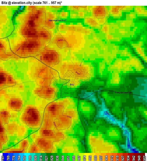
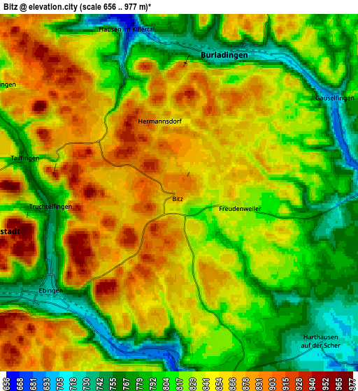
Below is the Elevation map of Bitz, which displays elevation range with different colors. Scale of the first map is from 761 to 957 m (2497 to 3140 ft) with average elevation of 870.5 meters (=2856 ft) [note 1]
These maps also provides idea of topography and contour of this city, they are displayed at different zoom levels. More info about maps, scale and edge coordinates you can find below images.
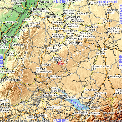
| \ | Map #1 | Map #2 | Topo.Map |
| Scale [m] | 761..957 m | 656..977 m | × |
| Scale [ft] | 2497..3140 ft | 2152..3205 ft | × |
| Average | 870.5 m = 2856 ft | 830.3 m = 2724 ft | × |
| Width | 6.51 km = 4 mi | 13.02 km = 8.1 mi | 208.3 km = 129.4 mi |
| Height | 6.51 km = 4 mi | 13.02 km = 8.1 mi | 208.2 km = 129.4 mi |
| ↑Max Latitude | 48.273257° | 48.302498° | 49.17194° |
| Latitude at center | 48.244° | 48.244° | 48.244° |
| ↓Min Latitude | 48.214726° | 48.185435° | 47.29891° |
| ← Min Longitude | 9.047495° | 9.003549° | 7.68519° |
| Longitude center | 9.09144° | 9.09144° | 9.09144° |
| →Max Longitude | 9.135385° | 9.179331° | 10.49769° |
Nearby cities:
Cities around Bitz sort by population:
• Albstadt elevation 733 m
5.7 km,  237°
237°
• Burladingen 738 m
5.5 km,  16°
16°
• Meßstetten 925 m
11.5 km,  234°
234°
• Bisingen 552 m
14.8 km,  299°
299°
• Gammertingen 704 m
9.8 km,  84°
84°
• Winterlingen 781 m
7 km,  164°
164°
• Trochtelfingen 695 m
13.4 km,  57°
57°
• Stetten am Kalten Markt 804 m
13.4 km,  184°
184°
• Straßberg 675 m
7.3 km, 180°
• Veringenstadt 651 m
11 km,  126°
126°
• Hettingen 649 m
10.8 km,  106°
106°
• Jungingen 590 m
10 km,  338°
338°
Multilingual:
 En español:
Bitz elevación 883 m.
 En France:
Bitz élévation 883 m.


Sources and notes:
- [note 1] Map square and city borders are not equal. Map elevation data is calculated only from area inside that square.
- [src 1] Elevation data from geonames database provided with same terms of usage.
- [src 2] The elevation map of Bitz is generated using elevation data from NASA's 3 arcsec (90m) resolution SRTM data.
- [src 3] Base (background) map © OpenStreetMap contributors tiles are generated by Geofabrik and OpenTopoMap.
Copyright & License:
This Bitz Elevation Map is licensed under CC BY-SA. You may reuse any part from this page, if you give a proper credit by linking to this URL:
 More info on terms of use page.