Hettingen elevation
Hettingen (Baden-Württemberg, Tübingen Region), Germany elevation is 649 meters and Hettingen elevation in feet is 2129 ft above sea level [src 1]. Hettingen is a populated place (feature code) with elevation that is 391 meters (1283 ft) bigger than average city elevation in Germany.
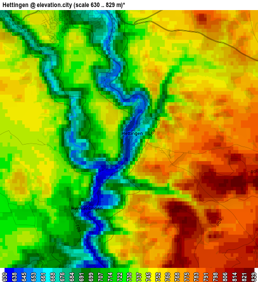
Below is the Elevation map of Hettingen, which displays elevation range with different colors. Scale of the first map is from 630 to 829 m (2067 to 2720 ft) with average elevation of 740.5 meters (=2429 ft) [note 1]
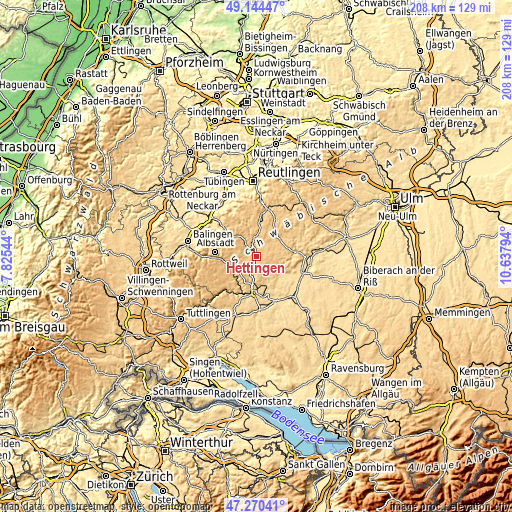
These maps also provides idea of topography and contour of this city, they are displayed at different zoom levels. More info about maps, scale and edge coordinates you can find below images.
| \ | Map #1 | Topo.Map |
| Scale [m] | 630..829 m | × |
| Scale [ft] | 2067..2720 ft | × |
| Average | 740.5 m = 2429 ft | × |
| Width | 6.51 km = 4 mi | 208.4 km = 129.5 mi |
| Height | 6.51 km = 4 mi | 208.4 km = 129.5 mi |
| ↑Max Latitude | 48.245283° | 49.14447° |
| Latitude at center | 48.21601° | 48.21601° |
| ↓Min Latitude | 48.18672° | 47.27041° |
| ← Min Longitude | 9.187745° | 7.82544° |
| Longitude center | 9.23169° | 9.23169° |
| →Max Longitude | 9.275635° | 10.63794° |
Nearby cities:
Cities around Hettingen sort by population:
• Albstadt elevation 733 m
15.2 km,  270°
270°
• Sigmaringen 592 m
14.2 km,  180°
180°
• Burladingen 738 m
12.1 km,  313°
313°
• Gammertingen 704 m
4.1 km,  351°
351°
• Winterlingen 781 m
9.3 km,  246°
246°
• Trochtelfingen 695 m
10.3 km,  5°
5°
• Bitz 883 m
10.8 km,  286°
286°
• Langenenslingen 573 m
13.2 km,  124°
124°
• Bingen 610 m
12 km,  165°
165°
• Straßberg 675 m
11.3 km, 248°
• Veringenstadt 651 m
3.8 km,  204°
204°
• Pfronstetten 754 m
11.6 km,  54°
54°
Multilingual:
 En español:
Hettingen elevación 649 m.
 En France:
Hettingen élévation 649 m.
 Auf Deutsch:
Hettingen höhe über dem Meeresspiegel ist 649 m.

Sources and notes:
- [note 1] Map square and city borders are not equal. Map elevation data is calculated only from area inside that square.
- [src 1] Elevation data from geonames database provided with same terms of usage.
- [src 2] The elevation map of Hettingen is generated using elevation data from NASA's 3 arcsec (90m) resolution SRTM data.
- [src 3] Base (background) map © OpenStreetMap contributors tiles are generated by Geofabrik and OpenTopoMap.
Copyright & License:
This Hettingen Elevation Map is licensed under CC BY-SA. You may reuse any part from this page, if you give a proper credit by linking to this URL:
 More info on terms of use page.