Blankenhain elevation
Blankenhain (Thuringia), Germany elevation is 356 meters and Blankenhain elevation in feet is 1168 ft above sea level [src 1]. Blankenhain is a populated place (feature code) with elevation that is 98 meters (322 ft) bigger than average city elevation in Germany.
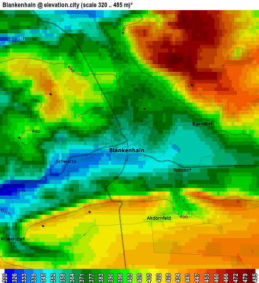
Below is the Elevation map of Blankenhain, which displays elevation range with different colors. Scale of the first map is from 320 to 485 m (1050 to 1591 ft) with average elevation of 399.9 meters (=1312 ft) [note 1]
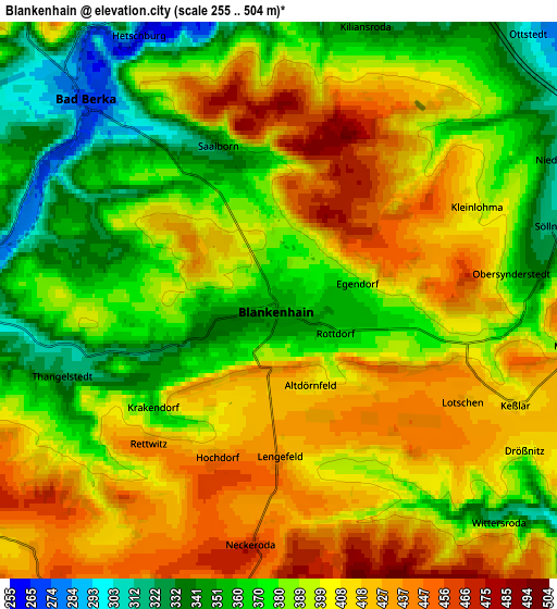
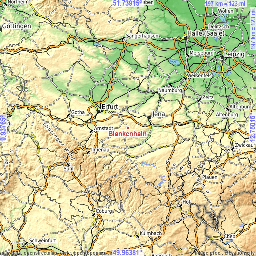
These maps also provides idea of topography and contour of this city, they are displayed at different zoom levels. More info about maps, scale and edge coordinates you can find below images.
| \ | Map #1 | Map #2 | Topo.Map |
| Scale [m] | 320..485 m | 255..504 m | × |
| Scale [ft] | 1050..1591 ft | 837..1654 ft | × |
| Average | 399.9 m = 1312 ft | 393.6 m = 1291 ft | × |
| Width | 6.17 km = 3.8 mi | 12.34 km = 7.7 mi | 197.4 km = 122.7 mi |
| Height | 6.17 km = 3.8 mi | 12.34 km = 7.7 mi | 197.4 km = 122.7 mi |
| ↑Max Latitude | 50.887661° | 50.915375° | 51.73915° |
| Latitude at center | 50.85993° | 50.85993° | 50.85993° |
| ↓Min Latitude | 50.832183° | 50.804419° | 49.96381° |
| ← Min Longitude | 11.299955° | 11.256009° | 9.93765° |
| Longitude center | 11.3439° | 11.3439° | 11.3439° |
| →Max Longitude | 11.387845° | 11.431791° | 12.75015° |
Nearby cities:
Cities around Blankenhain sort by population:
• Weimar elevation 220 m
13.4 km,  355°
355°
• Rudolstadt 197 m
15.5 km,  180°
180°
• Bad Berka 273 m
6.2 km,  315°
315°
• Kranichfeld 305 m
10.1 km,  266°
266°
• Barchfeld 314 m
12 km,  253°
253°
• Magdala 275 m
9 km,  54°
54°
• Nohra 318 m
12.7 km,  332°
332°
• Schwarza 334 m
1.5 km,  243°
243°
• Klettbach 392 m
15 km,  294°
294°
• Orlamünde 251 m
15.5 km,  127°
127°
• Mellingen 228 m
9.8 km,  22°
22°
• Bucha 361 m
12.4 km,  77°
77°
Multilingual:
 En español:
Blankenhain elevación 356 m.
 En France:
Blankenhain élévation 356 m.
 Auf Deutsch:
Blankenhain höhe über dem Meeresspiegel ist 356 m.

Sources and notes:
- [note 1] Map square and city borders are not equal. Map elevation data is calculated only from area inside that square.
- [src 1] Elevation data from geonames database provided with same terms of usage.
- [src 2] The elevation map of Blankenhain is generated using elevation data from NASA's 3 arcsec (90m) resolution SRTM data.
- [src 3] Base (background) map © OpenStreetMap contributors tiles are generated by Geofabrik and OpenTopoMap.
Copyright & License:
This Blankenhain Elevation Map is licensed under CC BY-SA. You may reuse any part from this page, if you give a proper credit by linking to this URL:
 More info on terms of use page.