Bornheim elevation
Bornheim (North Rhine-Westphalia, Regierungsbezirk Köln), Germany elevation is 62 meters and Bornheim elevation in feet is 203 ft above sea level [src 1]. Bornheim is a populated place (feature code) with elevation that is 196 meters (643 ft) smaller than average city elevation in Germany.
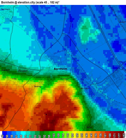
Below is the Elevation map of Bornheim, which displays elevation range with different colors. Scale of the first map is from 45 to 182 m (148 to 597 ft) with average elevation of 85.9 meters (=282 ft) [note 1]
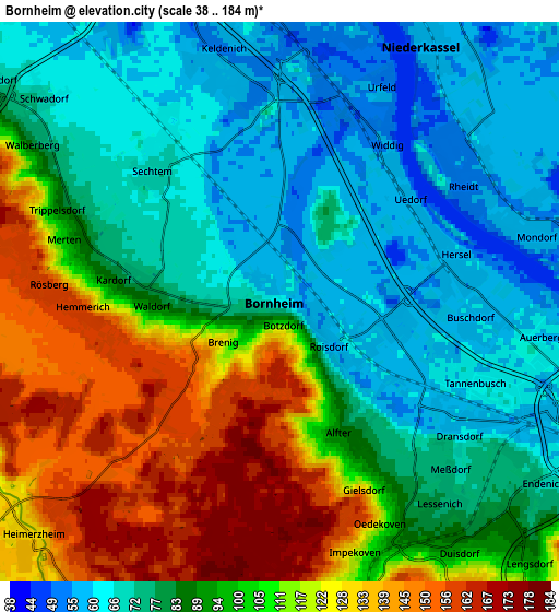
These maps also provides idea of topography and contour of this city, they are displayed at different zoom levels. More info about maps, scale and edge coordinates you can find below images.
| \ | Map #1 | Map #2 | Topo.Map |
| Scale [m] | 45..182 m | 38..184 m | × |
| Scale [ft] | 148..597 ft | 125..604 ft | × |
| Average | 85.9 m = 282 ft | 93.1 m = 305 ft | × |
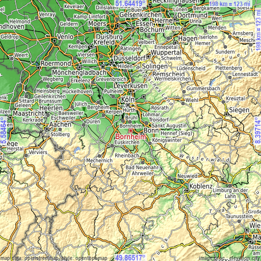
| Width | 6.18 km = 3.8 mi | 12.36 km = 7.7 mi | 197.8 km = 122.9 mi |
| Height | 6.18 km = 3.8 mi | 12.36 km = 7.7 mi | 197.8 km = 122.9 mi |
| ↑Max Latitude | 50.790918° | 50.81869° | 51.64419° |
| Latitude at center | 50.76313° | 50.76313° | 50.76313° |
| ↓Min Latitude | 50.735325° | 50.707504° | 49.86517° |
| ← Min Longitude | 6.946945° | 6.902999° | 5.58464° |
| Longitude center | 6.99089° | 6.99089° | 6.99089° |
| →Max Longitude | 7.034835° | 7.078781° | 8.39714° |
Nearby cities:
Cities around Bornheim sort by population:
• Bonn elevation 64 m
8 km,  113°
113°
• Troisdorf 55 m
12.3 km,  65°
65°
• Sankt Augustin 69 m
14.6 km,  84°
84°
• Hürth 91 m
14.8 km,  324°
324°
• Erftstadt 94 m
15 km,  292°
292°
• Brühl 68 m
9.5 km, 320°
• Niederkassel 59 m
6.6 km,  29°
29°
• Wesseling 50 m
7.2 km,  350°
350°
• Alfter 85 m
3.8 km,  151°
151°
• Weilerswist 120 m
10.3 km,  263°
263°
• Porz am Rhein 54 m
14.5 km,  19°
19°
• Wahn-Heide 59 m
13.4 km,  37°
37°
Multilingual:
 En español:
Bornheim elevación 62 m.
 En France:
Bornheim élévation 62 m.


Sources and notes:
- [note 1] Map square and city borders are not equal. Map elevation data is calculated only from area inside that square.
- [src 1] Elevation data from geonames database provided with same terms of usage.
- [src 2] The elevation map of Bornheim is generated using elevation data from NASA's 3 arcsec (90m) resolution SRTM data.
- [src 3] Base (background) map © OpenStreetMap contributors tiles are generated by Geofabrik and OpenTopoMap.
Copyright & License:
This Bornheim Elevation Map is licensed under CC BY-SA. You may reuse any part from this page, if you give a proper credit by linking to this URL:
 More info on terms of use page.