Brück elevation
Brück (Brandenburg), Germany elevation is 45 meters and Brück elevation in feet is 148 ft above sea level [src 1]. Brück is a populated place (feature code) with elevation that is 213 meters (699 ft) smaller than average city elevation in Germany.
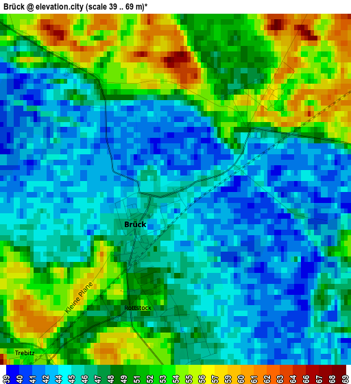
Below is the Elevation map of Brück, which displays elevation range with different colors. Scale of the first map is from 39 to 69 m (128 to 226 ft) with average elevation of 48.1 meters (=158 ft) [note 1]
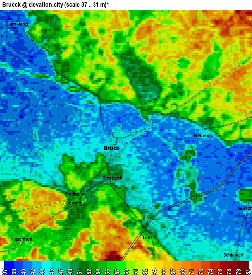
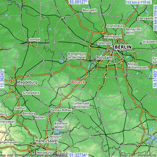
These maps also provides idea of topography and contour of this city, they are displayed at different zoom levels. More info about maps, scale and edge coordinates you can find below images.
| \ | Map #1 | Map #2 | Topo.Map |
| Scale [m] | 39..69 m | 37..81 m | × |
| Scale [ft] | 128..226 ft | 121..266 ft | × |
| Average | 48.1 m = 158 ft | 52.3 m = 172 ft | × |
| Width | 5.99 km = 3.7 mi | 11.98 km = 7.4 mi | 191.7 km = 119.1 mi |
| Height | 5.99 km = 3.7 mi | 11.98 km = 7.4 mi | 191.7 km = 119.1 mi |
| ↑Max Latitude | 52.224588° | 52.251499° | 53.05127° |
| Latitude at center | 52.19766° | 52.19766° | 52.19766° |
| ↓Min Latitude | 52.170716° | 52.143756° | 51.32734° |
| ← Min Longitude | 12.724735° | 12.680789° | 11.36243° |
| Longitude center | 12.76868° | 12.76868° | 12.76868° |
| →Max Longitude | 12.812625° | 12.856571° | 14.17493° |
Nearby cities:
Cities around Brück sort by population:
• Werder elevation 33 m
23.1 km,  29°
29°
• Beelitz 40 m
14.5 km,  71°
71°
• Bad Belzig 84 m
13.5 km,  242°
242°
• Michendorf 47 m
22 km,  54°
54°
• Kloster Lehnin 38 m
13.8 km,  352°
352°
• Treuenbrietzen 62 m
13.2 km,  147°
147°
• Groß Kreutz 32 m
22.8 km,  1°
1°
• Fichtenwalde 75 m
12.1 km,  40°
40°
• Niemegk 80 m
14.8 km,  201°
201°
• Borkheide 69 m
5.9 km, 69°
• Borkwalde 67 m
7.3 km, 37°
• Golzow 42 m
14.4 km,  307°
307°
Multilingual:
 En español:
Brück elevación 45 m.
 En France:
Brück élévation 45 m.


Sources and notes:
- [note 1] Map square and city borders are not equal. Map elevation data is calculated only from area inside that square.
- [src 1] Elevation data from geonames database provided with same terms of usage.
- [src 2] The elevation map of Brück is generated using elevation data from NASA's 3 arcsec (90m) resolution SRTM data.
- [src 3] Base (background) map © OpenStreetMap contributors tiles are generated by Geofabrik and OpenTopoMap.
Copyright & License:
This Brück Elevation Map is licensed under CC BY-SA. You may reuse any part from this page, if you give a proper credit by linking to this URL:
 More info on terms of use page.