Deggendorf elevation
Deggendorf (Bavaria, Lower Bavaria), Germany elevation is 320 meters and Deggendorf elevation in feet is 1050 ft above sea level [src 1]. Deggendorf is a seat of a third-order administrative division (feature code) with elevation that is 62 meters (203 ft) bigger than average city elevation in Germany.
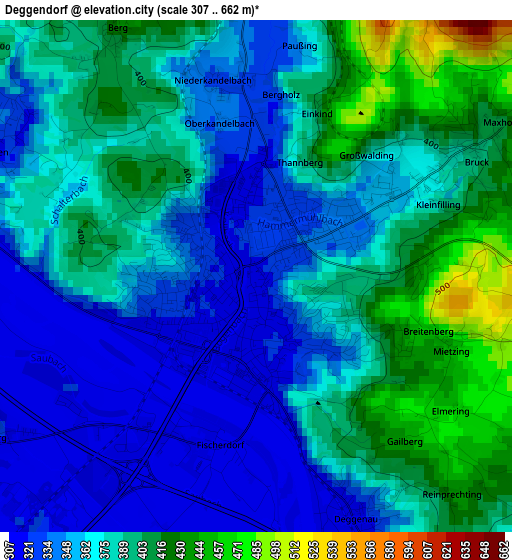
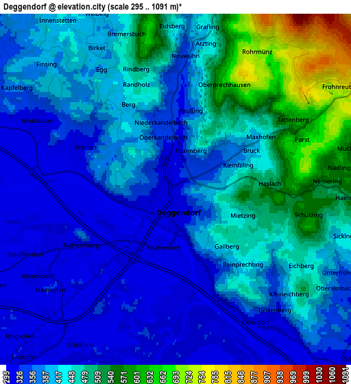
Below is the Elevation map of Deggendorf, which displays elevation range with different colors. Scale of the first map is from 307 to 662 m (1007 to 2172 ft) with average elevation of 374.2 meters (=1228 ft) [note 1]
These maps also provides idea of topography and contour of this city, they are displayed at different zoom levels. More info about maps, scale and edge coordinates you can find below images.
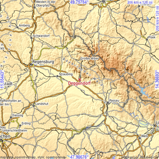
| \ | Map #1 | Map #2 | Topo.Map |
| Scale [m] | 307..662 m | 295..1091 m | × |
| Scale [ft] | 1007..2172 ft | 968..3579 ft | × |
| Average | 374.2 m = 1228 ft | 420.5 m = 1380 ft | × |
| Width | 6.43 km = 4 mi | 12.86 km = 8 mi | 205.8 km = 127.9 mi |
| Height | 6.43 km = 4 mi | 12.86 km = 8 mi | 205.8 km = 127.9 mi |
| ↑Max Latitude | 48.869764° | 48.898662° | 49.75784° |
| Latitude at center | 48.84085° | 48.84085° | 48.84085° |
| ↓Min Latitude | 48.811919° | 48.782971° | 47.90676° |
| ← Min Longitude | 12.916735° | 12.872789° | 11.55443° |
| Longitude center | 12.96068° | 12.96068° | 12.96068° |
| →Max Longitude | 13.004625° | 13.048571° | 14.36693° |
Nearby cities:
Cities around Deggendorf sort by population:
• Plattling elevation 319 m
9.3 km,  222°
222°
• Hengersberg 322 m
10.3 km,  137°
137°
• Bernried 382 m
10.2 km,  326°
326°
• Metten 317 m
3.7 km,  295°
295°
• Offenberg 316 m
7.5 km,  288°
288°
• Bischofsmais 680 m
12.3 km,  45°
45°
• Stephansposching 327 m
12.1 km,  257°
257°
• Auerbach 328 m
11 km,  112°
112°
• Niederalteich 311 m
9.6 km,  150°
150°
• Böbrach 464 m
11.7 km, 331°
• Schaufling 495 m
7.8 km,  82°
82°
• Mariaposching 312 m
11.8 km,  265°
265°
Multilingual:
 En español:
Deggendorf elevación 320 m.
 En France:
Deggendorf élévation 320 m.
 Auf Deutsch:
Deggendorf höhe über dem Meeresspiegel ist 320 m.

Sources and notes:
- [note 1] Map square and city borders are not equal. Map elevation data is calculated only from area inside that square.
- [src 1] Elevation data from geonames database provided with same terms of usage.
- [src 2] The elevation map of Deggendorf is generated using elevation data from NASA's 3 arcsec (90m) resolution SRTM data.
- [src 3] Base (background) map © OpenStreetMap contributors tiles are generated by Geofabrik and OpenTopoMap.
Copyright & License:
This Deggendorf Elevation Map is licensed under CC BY-SA. You may reuse any part from this page, if you give a proper credit by linking to this URL:
 More info on terms of use page.