Metten elevation
Metten (Bavaria, Lower Bavaria), Germany elevation is 317 meters and Metten elevation in feet is 1040 ft above sea level [src 1]. Metten is a populated place (feature code) with elevation that is 59 meters (194 ft) bigger than average city elevation in Germany.
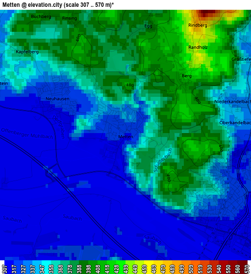
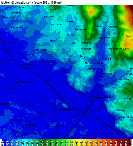
Below is the Elevation map of Metten, which displays elevation range with different colors. Scale of the first map is from 307 to 570 m (1007 to 1870 ft) with average elevation of 350.7 meters (=1151 ft) [note 1]
These maps also provides idea of topography and contour of this city, they are displayed at different zoom levels. More info about maps, scale and edge coordinates you can find below images.
| \ | Map #1 | Map #2 | Topo.Map |
| Scale [m] | 307..570 m | 295..1010 m | × |
| Scale [ft] | 1007..1870 ft | 968..3314 ft | × |
| Average | 350.7 m = 1151 ft | 378.6 m = 1242 ft | × |
| Width | 6.43 km = 4 mi | 12.86 km = 8 mi | 205.8 km = 127.9 mi |
| Height | 6.43 km = 4 mi | 12.86 km = 8 mi | 205.7 km = 127.8 mi |
| ↑Max Latitude | 48.884026° | 48.912916° | 49.77185° |
| Latitude at center | 48.85512° | 48.85512° | 48.85512° |
| ↓Min Latitude | 48.826197° | 48.797258° | 47.92129° |
| ← Min Longitude | 12.871595° | 12.827649° | 11.50929° |
| Longitude center | 12.91554° | 12.91554° | 12.91554° |
| →Max Longitude | 12.959485° | 13.003431° | 14.32179° |
Nearby cities:
Cities around Metten sort by population:
• Deggendorf elevation 320 m
3.7 km,  115°
115°
• Plattling 319 m
9 km,  199°
199°
• Bernried 382 m
7.2 km,  341°
341°
• Offenberg 316 m
3.9 km,  281°
281°
• Stephansposching 327 m
9.5 km,  243°
243°
• Schwarzach 366 m
10.2 km,  311°
311°
• Niederwinkling 319 m
9 km,  290°
290°
• Niederalteich 311 m
12.7 km,  141°
141°
• Böbrach 464 m
9 km, 344°
• Schaufling 495 m
11.1 km,  92°
92°
• Mariaposching 312 m
8.8 km,  254°
254°
• Irlbach 317 m
12.1 km,  262°
262°
Multilingual:
 En español:
Metten elevación 317 m.
 En France:
Metten élévation 317 m.


Sources and notes:
- [note 1] Map square and city borders are not equal. Map elevation data is calculated only from area inside that square.
- [src 1] Elevation data from geonames database provided with same terms of usage.
- [src 2] The elevation map of Metten is generated using elevation data from NASA's 3 arcsec (90m) resolution SRTM data.
- [src 3] Base (background) map © OpenStreetMap contributors tiles are generated by Geofabrik and OpenTopoMap.
Copyright & License:
This Metten Elevation Map is licensed under CC BY-SA. You may reuse any part from this page, if you give a proper credit by linking to this URL:
 More info on terms of use page.