Dinkelscherben elevation
Dinkelscherben (Bavaria, Swabia), Germany elevation is 465 meters and Dinkelscherben elevation in feet is 1526 ft above sea level [src 1]. Dinkelscherben is a populated place (feature code) with elevation that is 207 meters (679 ft) bigger than average city elevation in Germany.
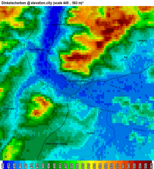
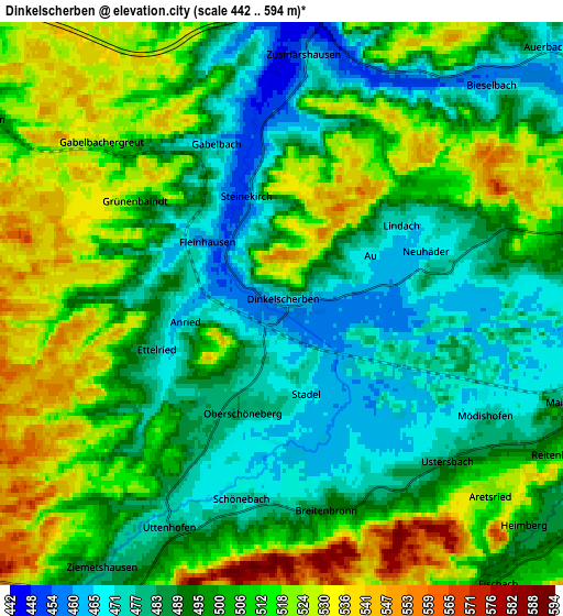
Below is the Elevation map of Dinkelscherben, which displays elevation range with different colors. Scale of the first map is from 449 to 563 m (1473 to 1847 ft) with average elevation of 481 meters (=1578 ft) [note 1]
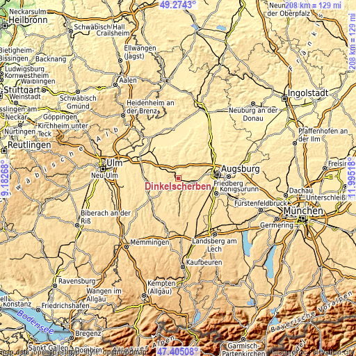
These maps also provides idea of topography and contour of this city, they are displayed at different zoom levels. More info about maps, scale and edge coordinates you can find below images.
| \ | Map #1 | Map #2 | Topo.Map |
| Scale [m] | 449..563 m | 442..594 m | × |
| Scale [ft] | 1473..1847 ft | 1450..1949 ft | × |
| Average | 481 m = 1578 ft | 499.8 m = 1640 ft | × |
| Width | 6.49 km = 4 mi | 12.99 km = 8.1 mi | 207.8 km = 129.1 mi |
| Height | 6.49 km = 4 mi | 12.99 km = 8.1 mi | 207.8 km = 129.1 mi |
| ↑Max Latitude | 48.377458° | 48.406639° | 49.2743° |
| Latitude at center | 48.34826° | 48.34826° | 48.34826° |
| ↓Min Latitude | 48.319046° | 48.289814° | 47.40508° |
| ← Min Longitude | 10.544985° | 10.501039° | 9.18268° |
| Longitude center | 10.58893° | 10.58893° | 10.58893° |
| →Max Longitude | 10.632875° | 10.676821° | 11.99518° |
Nearby cities:
Cities around Dinkelscherben sort by population:
• Jettingen-Scheppach elevation 472 m
12.1 km,  292°
292°
• Zusmarshausen 465 m
5.8 km,  7°
7°
• Thannhausen 504 m
11.4 km,  230°
230°
• Fischach 497 m
8.1 km,  142°
142°
• Gessertshausen 482 m
10.8 km,  101°
101°
• Burtenbach 512 m
10.1 km,  265°
265°
• Ziemetshausen 482 m
7.4 km,  212°
212°
• Kutzenhausen 482 m
7.8 km, 95°
• Horgau 466 m
8.7 km,  53°
53°
• Münsterhausen 493 m
10.8 km,  246°
246°
• Langenneufnach 540 m
9.1 km,  174°
174°
• Ustersbach 487 m
5.7 km,  127°
127°
Multilingual:
 En español:
Dinkelscherben elevación 465 m.
 En France:
Dinkelscherben élévation 465 m.
 Auf Deutsch:
Dinkelscherben höhe über dem Meeresspiegel ist 465 m.

Sources and notes:
- [note 1] Map square and city borders are not equal. Map elevation data is calculated only from area inside that square.
- [src 1] Elevation data from geonames database provided with same terms of usage.
- [src 2] The elevation map of Dinkelscherben is generated using elevation data from NASA's 3 arcsec (90m) resolution SRTM data.
- [src 3] Base (background) map © OpenStreetMap contributors tiles are generated by Geofabrik and OpenTopoMap.
Copyright & License:
This Dinkelscherben Elevation Map is licensed under CC BY-SA. You may reuse any part from this page, if you give a proper credit by linking to this URL:
 More info on terms of use page.