Fehrbellin elevation
Fehrbellin (Brandenburg), Germany elevation is 39 meters and Fehrbellin elevation in feet is 128 ft above sea level [src 1]. Fehrbellin is a seat of a fourth-order administrative division (feature code) with elevation that is 219 meters (719 ft) smaller than average city elevation in Germany.
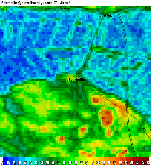
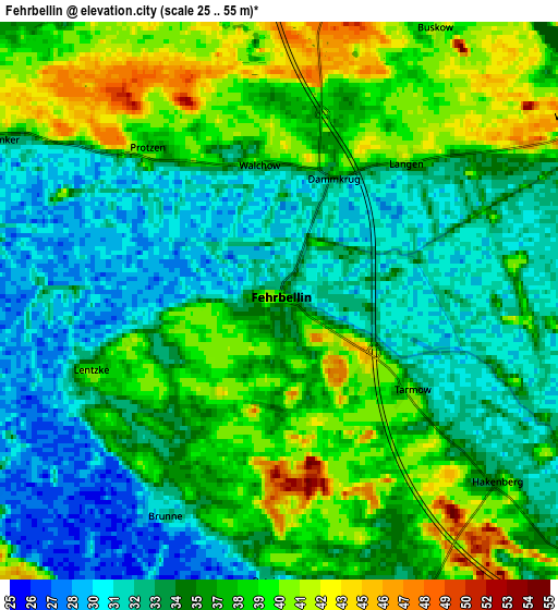
Below is the Elevation map of Fehrbellin, which displays elevation range with different colors. Scale of the first map is from 27 to 49 m (89 to 161 ft) with average elevation of 34.2 meters (=112 ft) [note 1]
These maps also provides idea of topography and contour of this city, they are displayed at different zoom levels. More info about maps, scale and edge coordinates you can find below images.
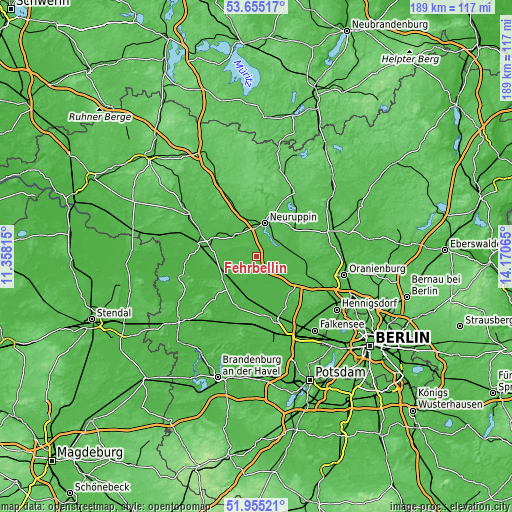
| \ | Map #1 | Map #2 | Topo.Map |
| Scale [m] | 27..49 m | 25..55 m | × |
| Scale [ft] | 89..161 ft | 82..180 ft | × |
| Average | 34.2 m = 112 ft | 35.5 m = 116 ft | × |
| Width | 5.91 km = 3.7 mi | 11.81 km = 7.3 mi | 189 km = 117.4 mi |
| Height | 5.91 km = 3.7 mi | 11.81 km = 7.3 mi | 189 km = 117.4 mi |
| ↑Max Latitude | 52.840053° | 52.86659° | 53.65517° |
| Latitude at center | 52.8135° | 52.8135° | 52.8135° |
| ↓Min Latitude | 52.786931° | 52.760345° | 51.95521° |
| ← Min Longitude | 12.720455° | 12.676509° | 11.35815° |
| Longitude center | 12.7644° | 12.7644° | 12.7644° |
| →Max Longitude | 12.808345° | 12.852291° | 14.17065° |
Nearby cities:
Cities around Fehrbellin sort by population:
• Neuruppin elevation 45 m
13 km,  11°
11°
• Nauen 37 m
24.1 km,  162°
162°
• Brieselang 30 m
30.1 km,  148°
148°
• Kyritz 45 m
28.5 km,  300°
300°
• Kremmen 38 m
18.4 km,  108°
108°
• Wusterhausen 36 m
22.2 km,  292°
292°
• Lindow 41 m
22.6 km,  40°
40°
• Friesack 34 m
15 km,  235°
235°
• Nennhausen 33 m
29.7 km,  216°
216°
• Rhinow 30 m
29.3 km,  256°
256°
• Paulinenaue 29 m
15.6 km,  193°
193°
• Dreetz 29 m
20.5 km,  266°
266°
Multilingual:
 En español:
Fehrbellin elevación 39 m.
 En France:
Fehrbellin élévation 39 m.
 Auf Deutsch:
Fehrbellin höhe über dem Meeresspiegel ist 39 m.

Sources and notes:
- [note 1] Map square and city borders are not equal. Map elevation data is calculated only from area inside that square.
- [src 1] Elevation data from geonames database provided with same terms of usage.
- [src 2] The elevation map of Fehrbellin is generated using elevation data from NASA's 3 arcsec (90m) resolution SRTM data.
- [src 3] Base (background) map © OpenStreetMap contributors tiles are generated by Geofabrik and OpenTopoMap.
Copyright & License:
This Fehrbellin Elevation Map is licensed under CC BY-SA. You may reuse any part from this page, if you give a proper credit by linking to this URL:
 More info on terms of use page.