Föhren elevation
Föhren (Rheinland-Pfalz), Germany elevation is 192 meters and Föhren elevation in feet is 630 ft above sea level [src 1]. Föhren is a seat of a fourth-order administrative division (feature code) with elevation that is 66 meters (217 ft) smaller than average city elevation in Germany.
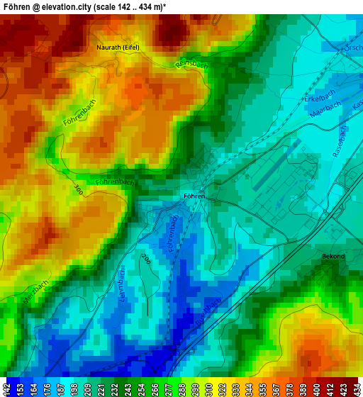
Below is the Elevation map of Föhren, which displays elevation range with different colors. Scale of the first map is from 142 to 434 m (466 to 1424 ft) with average elevation of 259.9 meters (=853 ft) [note 1]
These maps also provides idea of topography and contour of this city, they are displayed at different zoom levels. More info about maps, scale and edge coordinates you can find below images.
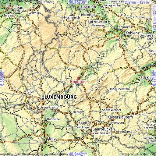
| \ | Map #1 | Topo.Map |
| Scale [m] | 142..434 m | × |
| Scale [ft] | 466..1424 ft | × |
| Average | 259.9 m = 853 ft | × |
| Width | 6.3 km = 3.9 mi | 201.6 km = 125.3 mi |
| Height | 6.3 km = 3.9 mi | 201.6 km = 125.3 mi |
| ↑Max Latitude | 49.887612° | 50.75736° |
| Latitude at center | 49.85929° | 49.85929° |
| ↓Min Latitude | 49.830952° | 48.94421° |
| ← Min Longitude | 6.720855° | 5.35855° |
| Longitude center | 6.7648° | 6.7648° |
| →Max Longitude | 6.808745° | 8.17105° |
Nearby cities:
Cities around Föhren sort by population:
• Schweich elevation 135 m
4.2 km,  191°
191°
• Zemmer 360 m
6.5 km,  314°
314°
• Kenn 171 m
7.4 km,  207°
207°
• Neumagen-Dhron 137 m
9.5 km,  92°
92°
• Mehring 154 m
8.2 km,  143°
143°
• Hetzerath 171 m
4.6 km,  54°
54°
• Leiwen 141 m
9.7 km,  119°
119°
• Klausen 276 m
9.6 km,  61°
61°
• Orenhofen 341 m
9.4 km,  298°
298°
• Longuich 133 m
5.7 km,  177°
177°
• Riol 134 m
7.6 km,  165°
165°
• Klüsserath 156 m
6.4 km,  104°
104°
Multilingual:
 En español:
Föhren elevación 192 m.
 En France:
Föhren élévation 192 m.


Sources and notes:
- [note 1] Map square and city borders are not equal. Map elevation data is calculated only from area inside that square.
- [src 1] Elevation data from geonames database provided with same terms of usage.
- [src 2] The elevation map of Föhren is generated using elevation data from NASA's 3 arcsec (90m) resolution SRTM data.
- [src 3] Base (background) map © OpenStreetMap contributors tiles are generated by Geofabrik and OpenTopoMap.
Copyright & License:
This Föhren Elevation Map is licensed under CC BY-SA. You may reuse any part from this page, if you give a proper credit by linking to this URL:
 More info on terms of use page.