Orenhofen elevation
Orenhofen (Rheinland-Pfalz), Germany elevation is 341 meters and Orenhofen elevation in feet is 1119 ft above sea level [src 1]. Orenhofen is a seat of a fourth-order administrative division (feature code) with elevation that is 83 meters (272 ft) bigger than average city elevation in Germany.
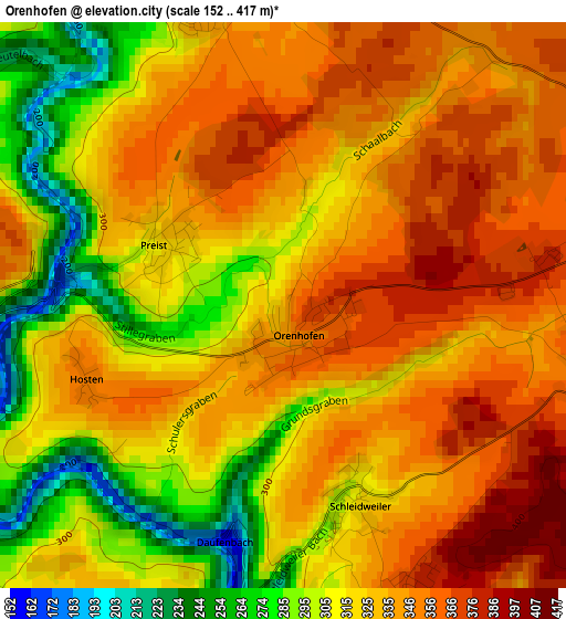
Below is the Elevation map of Orenhofen, which displays elevation range with different colors. Scale of the first map is from 152 to 417 m (499 to 1368 ft) with average elevation of 326.9 meters (=1073 ft) [note 1]
These maps also provides idea of topography and contour of this city, they are displayed at different zoom levels. More info about maps, scale and edge coordinates you can find below images.
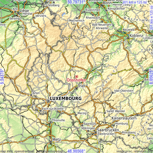
| \ | Map #1 | Topo.Map |
| Scale [m] | 152..417 m | × |
| Scale [ft] | 499..1368 ft | × |
| Average | 326.9 m = 1073 ft | × |
| Width | 6.29 km = 3.9 mi | 201.4 km = 125.1 mi |
| Height | 6.29 km = 3.9 mi | 201.4 km = 125.1 mi |
| ↑Max Latitude | 49.928298° | 50.79731° |
| Latitude at center | 49.9° | 49.9° |
| ↓Min Latitude | 49.871685° | 48.98568° |
| ← Min Longitude | 6.606055° | 5.24375° |
| Longitude center | 6.65° | 6.65° |
| →Max Longitude | 6.693945° | 8.05625° |
Nearby cities:
Cities around Orenhofen sort by population:
• Bitburg elevation 327 m
11.6 km,  310°
310°
• Schweich 135 m
11.4 km,  139°
139°
• Speicher 311 m
3.9 km,  342°
342°
• Zemmer 360 m
3.6 km,  90°
90°
• Newel 359 m
10.9 km,  206°
206°
• Föhren 192 m
9.4 km,  118°
118°
• Welschbillig 357 m
8.2 km,  227°
227°
• Kordel 248 m
7.5 km,  189°
189°
• Badem 355 m
11.4 km,  347°
347°
• Binsfeld 323 m
8.8 km,  32°
32°
• Dudeldorf 277 m
8.4 km, 353°
• Herforst 314 m
6.6 km, 32°
Multilingual:
 En español:
Orenhofen elevación 341 m.
 En France:
Orenhofen élévation 341 m.
 Auf Deutsch:
Orenhofen höhe über dem Meeresspiegel ist 341 m.

Sources and notes:
- [note 1] Map square and city borders are not equal. Map elevation data is calculated only from area inside that square.
- [src 1] Elevation data from geonames database provided with same terms of usage.
- [src 2] The elevation map of Orenhofen is generated using elevation data from NASA's 3 arcsec (90m) resolution SRTM data.
- [src 3] Base (background) map © OpenStreetMap contributors tiles are generated by Geofabrik and OpenTopoMap.
Copyright & License:
This Orenhofen Elevation Map is licensed under CC BY-SA. You may reuse any part from this page, if you give a proper credit by linking to this URL:
 More info on terms of use page.