Fränkisch-Crumbach elevation
Fränkisch-Crumbach (Hesse, Regierungsbezirk Darmstadt), Germany elevation is 192 meters and Fränkisch-Crumbach elevation in feet is 630 ft above sea level [src 1]. Fränkisch-Crumbach is a seat of a fourth-order administrative division (feature code) with elevation that is 66 meters (217 ft) smaller than average city elevation in Germany.
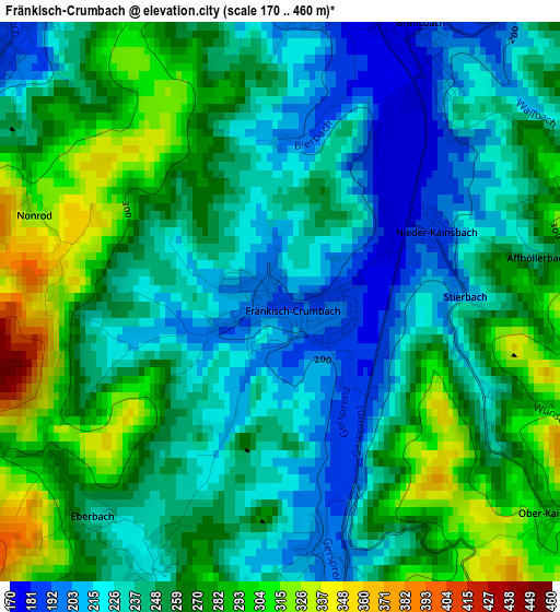
Below is the Elevation map of Fränkisch-Crumbach, which displays elevation range with different colors. Scale of the first map is from 170 to 460 m (558 to 1509 ft) with average elevation of 252.8 meters (=829 ft) [note 1]
These maps also provides idea of topography and contour of this city, they are displayed at different zoom levels. More info about maps, scale and edge coordinates you can find below images.
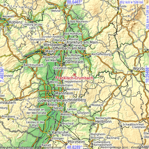
| \ | Map #1 | Topo.Map |
| Scale [m] | 170..460 m | × |
| Scale [ft] | 558..1509 ft | × |
| Average | 252.8 m = 829 ft | × |
| Width | 6.31 km = 3.9 mi | 202.1 km = 125.6 mi |
| Height | 6.31 km = 3.9 mi | 202.1 km = 125.6 mi |
| ↑Max Latitude | 49.774498° | 50.6463° |
| Latitude at center | 49.74611° | 49.74611° |
| ↓Min Latitude | 49.717705° | 48.8289° |
| ← Min Longitude | 8.814665° | 7.45236° |
| Longitude center | 8.85861° | 8.85861° |
| →Max Longitude | 8.902555° | 10.26486° |
Nearby cities:
Cities around Fränkisch-Crumbach sort by population:
• Reinheim elevation 169 m
9.4 km,  349°
349°
• Michelstadt 207 m
13 km,  126°
126°
• Ober-Ramstadt 214 m
12.3 km,  320°
320°
• Erbach 222 m
13.5 km, 134°
• Fürth 198 m
11.9 km,  206°
206°
• Höchst im Odenwald 156 m
11.7 km,  59°
59°
• Bad König 187 m
10.7 km,  91°
91°
• Reichelsheim 214 m
4 km,  200°
200°
• Lützelbach 400 m
6.6 km,  266°
266°
• Lindenfels 345 m
8.9 km,  218°
218°
• Brensbach 187 m
3.6 km,  30°
30°
• Groß-Bieberau 177 m
6.5 km,  337°
337°
Multilingual:
 En español:
Fränkisch-Crumbach elevación 192 m.
 En France:
Fränkisch-Crumbach élévation 192 m.
 Auf Deutsch:
Fränkisch-Crumbach höhe über dem Meeresspiegel ist 192 m.

Sources and notes:
- [note 1] Map square and city borders are not equal. Map elevation data is calculated only from area inside that square.
- [src 1] Elevation data from geonames database provided with same terms of usage.
- [src 2] The elevation map of Fränkisch-Crumbach is generated using elevation data from NASA's 3 arcsec (90m) resolution SRTM data.
- [src 3] Base (background) map © OpenStreetMap contributors tiles are generated by Geofabrik and OpenTopoMap.
Copyright & License:
This Fränkisch-Crumbach Elevation Map is licensed under CC BY-SA. You may reuse any part from this page, if you give a proper credit by linking to this URL:
 More info on terms of use page.