Freiberg am Neckar elevation
Freiberg am Neckar (Baden-Württemberg, Regierungsbezirk Stuttgart), Germany elevation is 256 meters and Freiberg am Neckar elevation in feet is 840 ft above sea level [src 1]. Freiberg am Neckar is a populated place (feature code) with elevation that is 2 meters (7 ft) smaller than average city elevation in Germany.
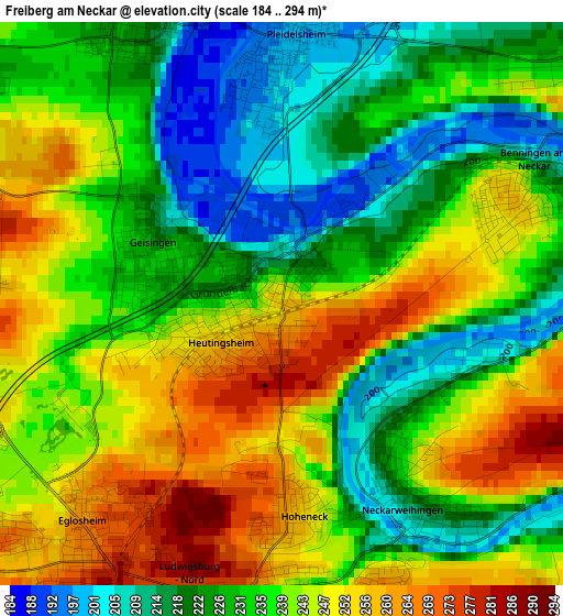
Below is the Elevation map of Freiberg am Neckar, which displays elevation range with different colors. Scale of the first map is from 184 to 294 m (604 to 965 ft) with average elevation of 236.2 meters (=775 ft) [note 1]
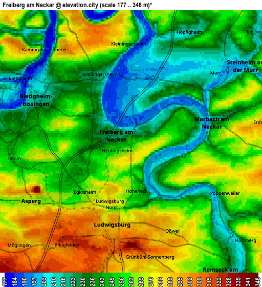
These maps also provides idea of topography and contour of this city, they are displayed at different zoom levels. More info about maps, scale and edge coordinates you can find below images.
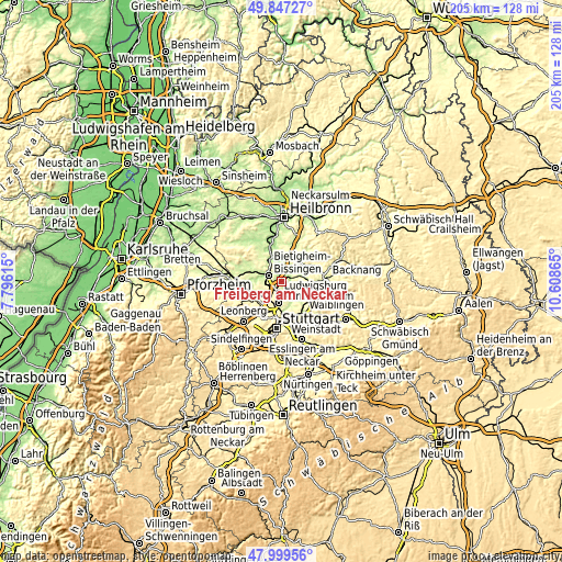
| \ | Map #1 | Map #2 | Topo.Map |
| Scale [m] | 184..294 m | 177..348 m | × |
| Scale [ft] | 604..965 ft | 581..1142 ft | × |
| Average | 236.2 m = 775 ft | 252.5 m = 828 ft | × |
| Width | 6.42 km = 4 mi | 12.84 km = 8 mi | 205.4 km = 127.6 mi |
| Height | 6.42 km = 4 mi | 12.84 km = 8 mi | 205.4 km = 127.6 mi |
| ↑Max Latitude | 48.960822° | 48.989667° | 49.84727° |
| Latitude at center | 48.93196° | 48.93196° | 48.93196° |
| ↓Min Latitude | 48.903082° | 48.874186° | 47.99956° |
| ← Min Longitude | 9.158455° | 9.114509° | 7.79615° |
| Longitude center | 9.2024° | 9.2024° | 9.2024° |
| →Max Longitude | 9.246345° | 9.290291° | 10.60865° |
Nearby cities:
Cities around Freiberg am Neckar sort by population:
• Ludwigsburg elevation 298 m
3.9 km,  191°
191°
• Bietigheim-Bissingen 226 m
6.3 km,  282°
282°
• Marbach am Neckar 242 m
4.3 km,  78°
78°
• Asperg 275 m
5.7 km,  238°
238°
• Tamm 256 m
6.5 km,  258°
258°
• Steinheim am der Murr 212 m
6.8 km,  53°
53°
• Möglingen 291 m
7.4 km,  228°
228°
• Pleidelsheim 199 m
3 km,  0°
0°
• Murr 207 m
5.3 km, 51°
• Benningen am Neckar 209 m
3.3 km,  60°
60°
• Erdmannhausen 278 m
6.9 km, 80°
• Hessigheim 204 m
7 km,  350°
350°
Multilingual:
 En español:
Freiberg am Neckar elevación 256 m.
 En France:
Freiberg am Neckar élévation 256 m.
 Auf Deutsch:
Freiberg am Neckar höhe über dem Meeresspiegel ist 256 m.
 На русском:
Фрайберг-ам-Неккар высота над уровнем моря 256 м
Sources and notes:
- [note 1] Map square and city borders are not equal. Map elevation data is calculated only from area inside that square.
- [src 1] Elevation data from geonames database provided with same terms of usage.
- [src 2] The elevation map of Freiberg am Neckar is generated using elevation data from NASA's 3 arcsec (90m) resolution SRTM data.
- [src 3] Base (background) map © OpenStreetMap contributors tiles are generated by Geofabrik and OpenTopoMap.
Copyright & License:
This Freiberg am Neckar Elevation Map is licensed under CC BY-SA. You may reuse any part from this page, if you give a proper credit by linking to this URL:
 More info on terms of use page.