Füssen elevation
Füssen (Bavaria, Swabia), Germany elevation is 800 meters and Füssen elevation in feet is 2625 ft above sea level [src 1]. Füssen is a populated place (feature code) with elevation that is 542 meters (1778 ft) bigger than average city elevation in Germany.
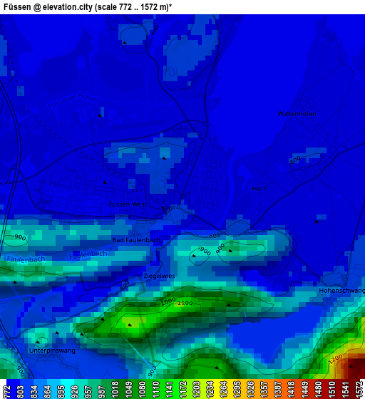
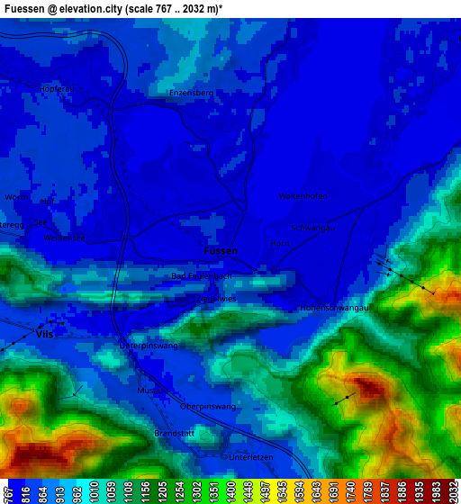
Below is the Elevation map of Füssen, which displays elevation range with different colors. Scale of the first map is from 772 to 1572 m (2533 to 5157 ft) with average elevation of 834.5 meters (=2738 ft) [note 1]
These maps also provides idea of topography and contour of this city, they are displayed at different zoom levels. More info about maps, scale and edge coordinates you can find below images.
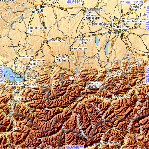
| \ | Map #1 | Map #2 | Topo.Map |
| Scale [m] | 772..1572 m | 767..2032 m | × |
| Scale [ft] | 2533..5157 ft | 2516..6667 ft | × |
| Average | 834.5 m = 2738 ft | 953.5 m = 3128 ft | × |
| Width | 6.59 km = 4.1 mi | 13.19 km = 8.2 mi | 211 km = 131.1 mi |
| Height | 6.59 km = 4.1 mi | 13.19 km = 8.2 mi | 211 km = 131.1 mi |
| ↑Max Latitude | 47.60107° | 47.630694° | 48.5116° |
| Latitude at center | 47.57143° | 47.57143° | 47.57143° |
| ↓Min Latitude | 47.541773° | 47.512099° | 46.61407° |
| ← Min Longitude | 10.657765° | 10.613819° | 9.29546° |
| Longitude center | 10.70171° | 10.70171° | 10.70171° |
| →Max Longitude | 10.745655° | 10.789601° | 12.10796° |
Nearby cities:
Cities around Füssen sort by population:
• Pfronten elevation 867 m
11.5 km,  275°
275°
• Halblech 810 m
11.1 km,  53°
53°
• Schwangau 800 m
2.5 km,  75°
75°
• Nesselwang 861 m
16 km,  291°
291°
• Seeg 868 m
11.6 km,  318°
318°
• Steingaden 805 m
18.9 km,  40°
40°
• Lechbruck 727 m
16.1 km,  25°
25°
• Bernbeuren 777 m
19.3 km,  17°
17°
• Stötten am Auerberg 734 m
18.6 km,  357°
357°
• Lengenwang 803 m
16.2 km,  331°
331°
• Görisried 803 m
20.8 km, 316°
• Hopferau 796 m
7.2 km,  314°
314°
Multilingual:
 En español:
Füssen elevación 800 m.
 En France:
Füssen élévation 800 m.


Sources and notes:
- [note 1] Map square and city borders are not equal. Map elevation data is calculated only from area inside that square.
- [src 1] Elevation data from geonames database provided with same terms of usage.
- [src 2] The elevation map of Füssen is generated using elevation data from NASA's 3 arcsec (90m) resolution SRTM data.
- [src 3] Base (background) map © OpenStreetMap contributors tiles are generated by Geofabrik and OpenTopoMap.
Copyright & License:
This Füssen Elevation Map is licensed under CC BY-SA. You may reuse any part from this page, if you give a proper credit by linking to this URL:
 More info on terms of use page.