Görisried elevation
Görisried (Bavaria, Swabia), Germany elevation is 803 meters and Görisried elevation in feet is 2635 ft above sea level [src 1]. Görisried is a seat of a fourth-order administrative division (feature code) with elevation that is 545 meters (1788 ft) bigger than average city elevation in Germany.
Below is the Elevation map of Görisried, which displays elevation range with different colors. Scale of the first map is from 764 to 947 m (2507 to 3107 ft) with average elevation of 838.3 meters (=2750 ft) [note 1]
These maps also provides idea of topography and contour of this city, they are displayed at different zoom levels. More info about maps, scale and edge coordinates you can find below images.
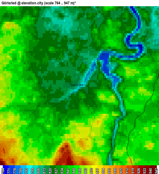
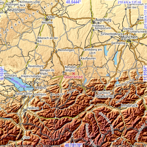
| \ | Map #1 | Topo.Map |
| Scale [m] | 764..947 m | × |
| Scale [ft] | 2507..3107 ft | × |
| Average | 838.3 m = 2750 ft | × |
| Width | 6.58 km = 4.1 mi | 210.4 km = 130.7 mi |
| Height | 6.58 km = 4.1 mi | 210.4 km = 130.7 mi |
| ↑Max Latitude | 47.736244° | 48.6444° |
| Latitude at center | 47.70668° | 47.70668° |
| ↓Min Latitude | 47.6771° | 46.75178° |
| ← Min Longitude | 10.466205° | 9.1039° |
| Longitude center | 10.51015° | 10.51015° |
| →Max Longitude | 10.554095° | 11.9164° |
Nearby cities:
Cities around Görisried sort by population:
• Marktoberdorf elevation 728 m
11.4 km,  44°
44°
• Durach 718 m
12.5 km,  263°
263°
• Sulzberg 714 m
13.1 km,  246°
246°
• Oy-Mittelberg 977 m
10 km,  215°
215°
• Nesselwang 861 m
9.3 km,  183°
183°
• Betzigau 737 m
9.9 km,  287°
287°
• Seeg 868 m
9.2 km,  133°
133°
• Unterthingau 773 m
7.2 km,  356°
356°
• Wildpoldsried 723 m
10.6 km,  309°
309°
• Aitrang 745 m
12.4 km,  8°
8°
• Ruderatshofen 742 m
13.4 km,  24°
24°
• Lengenwang 803 m
6.8 km,  96°
96°
Multilingual:
 En español:
Görisried elevación 803 m.
 En France:
Görisried élévation 803 m.
 Auf Deutsch:
Görisried höhe über dem Meeresspiegel ist 803 m.

Sources and notes:
- [note 1] Map square and city borders are not equal. Map elevation data is calculated only from area inside that square.
- [src 1] Elevation data from geonames database provided with same terms of usage.
- [src 2] The elevation map of Görisried is generated using elevation data from NASA's 3 arcsec (90m) resolution SRTM data.
- [src 3] Base (background) map © OpenStreetMap contributors tiles are generated by Geofabrik and OpenTopoMap.
Copyright & License:
This Görisried Elevation Map is licensed under CC BY-SA. You may reuse any part from this page, if you give a proper credit by linking to this URL:
 More info on terms of use page.